Historic Centre of Guimarães
This article needs additional citations for verification. (January 2018) |
This article may be expanded with text translated from the corresponding article in Portuguese. (January 2018) Click [show] for important translation instructions.
|
| UNESCO World Heritage Site | |
|---|---|
 | |
| Location | Guimarães, Portugal |
| Criteria | Cultural: (ii), (iii), (iv) |
| Reference | 1031 |
| Inscription | 2001 (25th Session) |
| Area | 19.45 ha (48.1 acres) |
| Buffer zone | 99.23 ha (245.2 acres) |
| Coordinates | 41°26′37.432″N 8°17′34.091″W / 41.44373111°N 8.29280306°WCoordinates: 41°26′37.432″N 8°17′34.091″W / 41.44373111°N 8.29280306°W |
 Location of Historic Centre of Guimarães in Portugal | |

Historic Centre of Guimarães is an urban space of the city of Guimarães, in Portugal, tracing back to medieval age covering an area of 16 hectares and retaining many buildings from the medieval age until 19th century. Since 2001, it is declared as a World Heritage Site of UNESCO.[1]
Guimarães is closely linked to the formation of national identity and of Portuguese language in 12th century. It is the native city of Afonso Henriques, the first king of Portugal, who in 1139, declared independence of the country.
Gallery[]

Old Palace Council, Oliveira Square, Historic Centre of Guimarães
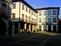
Old Town Hall and other buildings in Oliveira Square
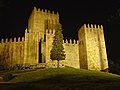
Night view of Castle of Guimarães

Oliveira Plaza and Arch of 14th Century.

Rua santa Maria.


See also[]
External links[]
| Wikimedia Commons has media related to Centro Histórico de Guimarães. |
| Wikivoyage has a travel guide for Guimarães. |
| Norte |
| |
|---|---|---|
| Centro | ||
| Lisboa |
| |
| Alentejo |
| |
| Azores |
| |
| Madeira |
| |
References[]
- ^ Centre, UNESCO World Heritage. "Historic Centre of Guimarães". whc.unesco.org. Retrieved 2017-05-17.
Categories:
- World Heritage Sites in Portugal
- Guimarães