Hiw (island)
Coordinates: 13°08′38″S 166°34′05″E / 13.144°S 166.568°E

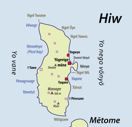 A detailed map of Hiw, showing modern villages (red) and ancient, now uninhabited villages (pink) | |
 | |
| Geography | |
|---|---|
| Location | Pacific Ocean |
| Archipelago | Vanuatu, Torres Islands |
| Area | 51 km2 (20 sq mi) |
| Highest elevation | 366 m (1201 ft) |
| Highest point | Mount Wonvara |
| Administration | |
Vanuatu | |
| Province | Torba Province |
| Demographics | |
| Population | 269 (2009) |
Hiw (sometimes spelled Hiu) is the northernmost island in Vanuatu, located in Torba Province.
Geography[]

Hiw is the largest island in the Torres Islands in Torba Province. It is situated east of the , south of Vanikoro in the Solomon Islands. It has an area of 51 square kilometres (20 square miles). The highest point is Mount Wonvara (366 metres (1,201 feet).
Hiu's climate is humid tropical. The average annual rainfall is about 4000 mm. The island is subject to frequent cyclones and earthquakes.
Vewoag Point (locally called Ngrë Twome), the northern cape of Hiw, is the northernmost point of land of Vanuatu. 1.6 kilometres (1.0 mile) of Hiw is a submerged coral reef, Ngwey Gakwe (formerly Recif Giraudeau), over which the waves break.
Population[]
Hiw has a population of about 270 inhabitants.[1]
They are distributed in three villages, all located on the east coast: Yogwye [ˈjɔɰwjə]; Yaqane [jaˈkʷanə]; and the main village Yögevigemëne [ˌjɵɣəˌβiɣəˈmenə], whose name is sometimes shortened to Yugemëne [ˌjʉɣəˈmenə].
The language spoken on the island is also called Hiw.
Transportation[]
The Torres islands are served by Torres Airport, which is located on the Linua island, south of Hiw.
References[]
- ^
"2009 National Census of Population and Housing: Summary Release" (PDF). Vanuatu National Statistics Office. 2009. Retrieved October 11, 2010. Cite journal requires
|journal=(help)

This Vanuatu location article is a stub. You can help Wikipedia by . |
- Hiw Island
- Islands of Vanuatu
- Torba Province
- Vanuatu geography stubs