Hoevelaken
Hoevelaken | |
|---|---|
Town | |
 Flag  Coat of arms | |
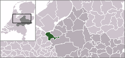 | |
 The town centre (dark green) and the statistical district (light green) of Hoevelaken in the municipality of Nijkerk. | |
| Coordinates: 52°10′N 5°28′E / 52.167°N 5.467°ECoordinates: 52°10′N 5°28′E / 52.167°N 5.467°E | |
| Country | Netherlands |
| Province | Gelderland |
| Municipality | Nijkerk |
| Population | |
| • Total | 9,040 |
| Time zone | UTC+1 (CET) |
| • Summer (DST) | UTC+2 (CEST) |

Hoevelaken is a town in the Dutch province of Gelderland. It is a part of the municipality of Nijkerk, and lies about 5 km east of Amersfoort.
Hoevelaken was a separate municipality until 2000, when it was merged with Nijkerk.[1]
In 2001, the town of Hoevelaken had 7990 inhabitants. The built-up area of the town was 2.2 km2 (0.85 sq mi), and contained 3044 residences.[2] The statistical area "Hoevelaken", which also can include the peripheral parts of the village, as well as the surrounding countryside, has a population of around 9040.[3]
Transport Links[]
In national context, the town is mostly known because of the homonymous motorway interchange between the E30, E231 and E232. This interchange is an important hub for north- and eastbound traffic in the Netherlands.
Hoevelaken railway station opened in 2012 to serve the town.
Notable residents[]
- Henry Timmer, football player
- Levi van Veluw, artist and photographer
- Conny Vandenbos, singer
References[]
- ^ Ad van der Meer and Onno Boonstra, Repertorium van Nederlandse gemeenten, KNAW, 2011.
- ^ Statistics Netherlands (CBS), Bevolkingskernen in Nederland 2001 Archived 2006-03-19 at the Wayback Machine. (Statistics are for the continuous built-up area).
- ^ Statistics Netherlands (CBS), Statline: Kerncijfers wijken en buurten 2003-2005. As of 1 January 2005.
External links[]
- J. Kuyper, Gemeente Atlas van Nederland, 1865-1870, "Hoevelaken". Map of the former municipality, around 1868.
| hide Authority control | |
|---|---|
| General |
|
| National libraries | |
This Gelderland location article is a stub. You can help Wikipedia by . |
- Populated places in Gelderland
- Former municipalities of Gelderland
- Nijkerk
- Gelderland geography stubs