Hohe Dock
| Hohe Dock | |
|---|---|
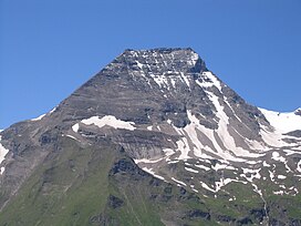 Hohe Dock from the Großglockner High Alpine Road | |
| Highest point | |
| Elevation | 3348 m AA |
| Isolation | 0.6 km (0.37 mi) |
| Coordinates | 47°07′51″N 12°44′27″E / 47.13083°N 12.74083°ECoordinates: 47°07′51″N 12°44′27″E / 47.13083°N 12.74083°E |
| Geography | |
 Hohe Dock Austria | |
| Location | Salzburg, Austria |
| Parent range | Glockner Group / High Tauern |
| Climbing | |
| First ascent | ca. 1842 - 1845 G. Mayer (Badhans) during a hunt[1] |

The Hohe Dock lies in the Austrian federal state of Salzburg and, at 3,348 metres, is one of the highest peaks in the Glockner Group. The mountain, with its striking trapezoidal shape, dominates the orographically left-hand side of the valley of the Fuscher Ache and the panorama above the northern ramp of the Großglockner High Alpine Road.
Its secondary peak, the southeastern summit, reaches a height of 3,268 m above sea level (AA).
Climbing route[]
The start point is the head of the valley at Fusch an der Großglocknerstraße (Ferleiten). The summit is ascended via the (2,267 m) along a signed, high alpine path.
References[]
External links[]
- Climbing the Hohe Dock - (Czech / English)
Gallery[]

The Hohe Dock from the northeast

Categories:
- Glockner Group
- Mountains of the Alps
- Mountains of Salzburg (state)
- Fusch an der Großglocknerstraße