Hohenleipisch
Hohenleipisch | |
|---|---|
 Coat of arms | |
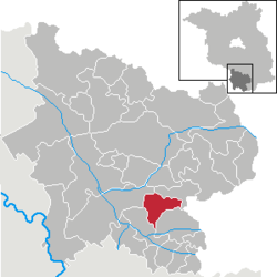
show Location of Hohenleipisch within Elbe-Elster district | |
 Hohenleipisch | |
| Coordinates: 51°30′00″N 13°33′00″E / 51.50000°N 13.55000°ECoordinates: 51°30′00″N 13°33′00″E / 51.50000°N 13.55000°E | |
| Country | Germany |
| State | Brandenburg |
| District | Elbe-Elster |
| Municipal assoc. | Plessa |
| Government | |
| • Mayor (2019–24) | Lutz Schumann[1] (SPD) |
| Area | |
| • Total | 34.81 km2 (13.44 sq mi) |
| Elevation | 135 m (443 ft) |
| Population (2020-12-31)[2] | |
| • Total | 1,949 |
| • Density | 56/km2 (150/sq mi) |
| Time zone | UTC+01:00 (CET) |
| • Summer (DST) | UTC+02:00 (CEST) |
| Postal codes | 04934 |
| Dialling codes | 03533 |
| Vehicle registration | EE, FI, LIB |


Hohenleipisch (Sorbian: Lubuš) is a municipality in the Elbe-Elster district, in Brandenburg, Germany.
History[]
Two kilometres west of Hohenleipisch is an old brown coal and quartz sand pit called Grube Gotthold.
Demography[]
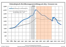
Development of Population since 1875 within the Current Boundaries (Blue Line: Population; Dotted Line: Comparison to Population Development of Brandenburg state; Grey Background: Time of Nazi rule; Red Background: Time of Communist rule)
|
|
|
|
References[]
- ^ Landkreis Elbe-Elster Wahl der Bürgermeisterin / des Bürgermeisters, accessed 1 July 2021.
- ^ "Bevölkerung im Land Brandenburg nach amtsfreien Gemeinden, Ämtern und Gemeinden 31. Dezember 2020". Amt für Statistik Berlin-Brandenburg (in German). June 2021.
- ^ Detailed data sources are to be found in the Wikimedia Commons.Population Projection Brandenburg at Wikimedia Commons
| show Towns and municipalities in Elbe-Elster |
|---|
| Authority control |
|---|
This Brandenburg location article is a stub. You can help Wikipedia by . |
Categories:
- Municipalities in Brandenburg
- Localities in Elbe-Elster
- Province of Saxony
- Bezirk Cottbus
- Brandenburg geography stubs