Hohenwestedt-Land
Hohenwestedt-Land | |
|---|---|
 Coat of arms | |
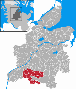
show Location of Hohenwestedt-Land within Rendsburg-Eckernförde district | |
 Hohenwestedt-Land | |
| Coordinates: 54°05′N 09°40′E / 54.083°N 9.667°ECoordinates: 54°05′N 09°40′E / 54.083°N 9.667°E | |
| Country | Germany |
| State | Schleswig-Holstein |
| District | Rendsburg-Eckernförde |
| Disbanded | 1 January 2012 |
| Subdivisions | 14 municipalities |
| Area | |
| • Total | 135.47 km2 (52.31 sq mi) |
| Population (2010-12-31) | |
| • Total | 6,188 |
| • Density | 46/km2 (120/sq mi) |
| Time zone | UTC+01:00 (CET) |
| • Summer (DST) | UTC+02:00 (CEST) |
| Vehicle registration | RD |
| Website | www.amthohenwestedt-land.de |


Hohenwestedt-Land is a former Amt ("collective municipality") in the district of Rendsburg-Eckernförde, in Schleswig-Holstein, Germany. It was situated around the town Hohenwestedt, which was the seat of the Amt, but not part of it. Since January 2007 Hohenwestedt-Land formed the Verwaltungsgemeinschaft Mittelholstein together with the Amt Aukrug, Amt Hanerau-Hademarschen and Hohenwestedt itself. Mittelholstein became an Amt on 1 January 2012, and the Amt Hohenwestedt-Land was disbanded.
Subdivision[]
The Amt Hohenwestedt-Land consisted of the following municipalities:
- Beringstedt
- Grauel
- Heinkenborstel
- Jahrsdorf
- Meezen
- Mörel
- Nienborstel
- Nindorf
- Osterstedt
- Rade bei Hohenwestedt
- Remmels
- Tappendorf
- Todenbüttel
- Wapelfeld
References[]
External links[]
- (in German) Hohenwestedt-Land official site
| Authority control |
|---|
Categories:
- Former Ämter in Schleswig-Holstein