Hohnstein
Hohnstein | |
|---|---|
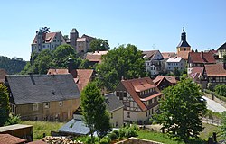 General view of the town | |
 Coat of arms | |
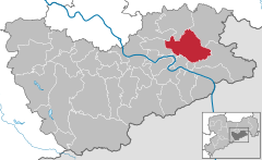
show Location of Hohnstein within Sächsische Schweiz-Osterzgebirge district | |
 Hohnstein | |
| Coordinates: 50°59′N 14°07′E / 50.983°N 14.117°ECoordinates: 50°59′N 14°07′E / 50.983°N 14.117°E | |
| Country | Germany |
| State | Saxony |
| District | Sächsische Schweiz-Osterzgebirge |
| Government | |
| • Mayor (2015–22) | Daniel Brade[1] |
| Area | |
| • Total | 64.61 km2 (24.95 sq mi) |
| Elevation | 330 m (1,080 ft) |
| Population (2020-12-31)[2] | |
| • Total | 3,262 |
| • Density | 50/km2 (130/sq mi) |
| Time zone | UTC+01:00 (CET) |
| • Summer (DST) | UTC+02:00 (CEST) |
| Postal codes | 01848 |
| Dialling codes | 035975 |
| Vehicle registration | PIR |
| Website | www.hohnstein.de |


Hohnstein (German pronunciation: [ˈhoːnˌʃtaɪ̯n] (![]() listen)) is a town located in the Sächsische Schweiz-Osterzgebirge district of the Free State of Saxony, Germany. As of 2010, its population numbered a total of 3,671.
listen)) is a town located in the Sächsische Schweiz-Osterzgebirge district of the Free State of Saxony, Germany. As of 2010, its population numbered a total of 3,671.
Geography[]
It is situated in Saxon Switzerland, 12 km east of Pirna, and 28 km southeast of Dresden (centre). It is dominated by its castle, standing on a sandstone rock.
Municipal territory includes the villages (Ortsteil) of Cunnersdorf, Ehrenberg, Goßdorf, Lohsdorf, Rathewalde, Ulbersdorf and Waitzdorf.
Gallery[]
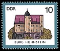
1985 stamp of the castle.

View of the town and the castle.
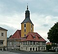
Town's church

Church in Rathewalde
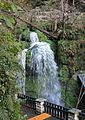
The Amsel Falls near Rathewalde


See also[]
- Hohnstein Castle (Saxon Switzerland)
- Schwarzbach Railway
- Goßdorf-Kohlmühle railway station
- Ulbersdorf railway station
References[]
- ^ Bürgermeisterwahlen 2015, Freistaat Sachsen, accessed 13 July 2021.
- ^ "Bevölkerung des Freistaates Sachsen nach Gemeinden am 31. Dezember 2020". Statistisches Landesamt des Freistaates Sachsen (in German). June 2021.
External links[]
![]() Media related to Hohnstein at Wikimedia Commons
Media related to Hohnstein at Wikimedia Commons
- Newsreel WK2 from a private archive: http://www.archiv-akh.de/filme#1549 (Material Nr 1966, Time 10:17:28)
| show Towns and municipalities in Sächsische Schweiz-Osterzgebirge district |
|---|
| show Authority control |
|---|
This Sächsische Schweiz-Osterzgebirge location article is a stub. You can help Wikipedia by . |
- Towns in Saxony
- Hohnstein
- Places in Saxon Switzerland
- Bezirk Dresden
- Sächsische Schweiz-Osterzgebirge district geography stubs