Holyhead Mountain
| Holyhead Mountain | |
|---|---|
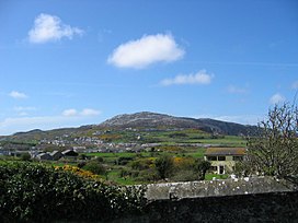 Holyhead Mountain from the town's New Park | |
| Highest point | |
| Elevation | 220 m (720 ft) |
| Prominence | 220 m (720 ft) |
| Parent peak | none - HP Holy Island |
| Listing | Marilyn, council top |
| Coordinates | 53°18′47″N 4°40′35″W / 53.31297°N 4.6763°WCoordinates: 53°18′47″N 4°40′35″W / 53.31297°N 4.6763°W |
| Geography | |
 Holyhead Mountain Anglesey, UK | |
| OS grid | SH218829 |
| Topo map | OS Landranger 114 |

Holyhead Mountain (Mynydd Twr in Welsh: from (pen)twr, meaning "tower") is the highest mountain on Holy Island, Anglesey, and the highest in the county of Anglesey, north Wales. It lies about two miles west of the town of Holyhead, and slopes steeply down to the Irish Sea on two sides. Ireland can be seen from here on a clear day and the mountain is an important site for seabirds.
The mountain[]
Holyhead Mountain is located on Holy Island, Anglesey, jutting out into the Irish Sea. At 722 feet (220 m), it is the highest mountain in the county of Anglesey, being higher than Bodafon Mountain (584 feet (178 m)) on the main island.[1] On the east side of the mountain is the site of a late Roman watchtower called Caer y Tŵr (Tower Fortress), from which Holyhead Mountain's Welsh name is derived. Holyhead Mountain also has the remains of a group of Iron Age huts near its foot. This shows evidence of being occupied in the middle part of the Stone Age, the Neolithic Age, the Bronze Age and the Iron Age. There are traces of field systems and the bases of dry-stone walls of twenty huts, and there are a number of standing stones in the vicinity.[2]
The summit of the mountain is rocky, quartzite, and the slopes clad in heather. The material for the breakwater at the port of Holyhead was quarried from the limestone areas of the northeastern side of the island, with seven million tons of limestone being removed from long established[3] quarries to form the longest breakwater in Britain, at nearly one and a half miles (2.4 km) long. On the mountain are also the remains of a brickworks, which closed in 1973. Specialist bricks produced here were also used in construction of the breakwater.[4]
Holyhead Mountain attracts many visitors, and it is also located close to South Stack lighthouse; many people come to see the variety of birds that nest along the cliff faces near South Stack. Views from the summit are extensive, especially to the west, where the Wicklow Mountains in Ireland can often be seen across the Irish Sea on clear days. Birds that nest here include Atlantic puffins, stonechats and Eurasian oystercatchers, and grey seals can be seen offshore during the summer.[4]
Gallery[]
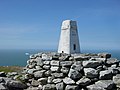
Trig point at the top of the mountain.
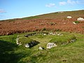
Prehistoric hut remains on the lower part of the mountain.

Holyhead Breakwater and harbour from the mountain.

North face of the mountain.

The mountain from the west coast of Anglesey.

Sunset over the mountain.

Main entrance to the Celtic fort.


References[]
- ^ 114 Anglesey (Map). 1:50000. Landranger. Ordnance Survey.
- ^ Breverton, Terry (2013). Wales' 1000 Best Heritage Sites. Amberley Publishing Limited. p. 86. ISBN 978-1-4456-2013-8.
- ^ Footsteps through tiime, the rocks and landscape of Anglesey Explained, Campbell, Wood and Windley, 2014
- ^ a b Plant, Steve (2014). A Wander Around the Coast of Wales. Fast-Print Publishing. pp. 68–70. ISBN 978-1-78035-761-4.
External links[]
- Marilyns of Wales
- Mountains and hills of Anglesey
- Highest points of Welsh counties
- Trearddur