Honmutabe Station
Honmutabe Station 本牟田部駅 | |
|---|---|
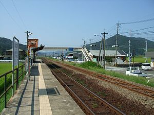 Honmutabe Station in 2008 | |
| Location | Japan |
| Coordinates | 33°22′20″N 129°59′48″E / 33.3721°N 129.9966°ECoordinates: 33°22′20″N 129°59′48″E / 33.3721°N 129.9966°E |
| Operated by | |
| Line(s) | ■ Karatsu Line |
| Distance | 30.1 km from Kubota |
| Platforms | 1 side platform |
| Tracks | 1 + 1 passing line |
| Construction | |
| Structure type | At grade |
| Bicycle facilities | Bike shed |
| Other information | |
| Status | Unstaffed |
| Website | Official website |
| History | |
| Opened | 1 February 1960 |
| Passengers | |
| FY2015 | 33 daily |
| Location | |
 Honmutabe Station Location within Japan | |

Honmutabe Station (本牟田部駅, Honmutabe-eki) is a railway station on the Karatsu Line operated by JR Kyushu located in Karatsu, Saga Prefecture, Japan.[1][2]
Lines[]
The station is served by the Karatsu Line and is located 30.1 km from the starting point of the line at Kubota.[3]
Station layout[]
The station, which is unstaffed, consists of a side platform serving a single track at grade. There is no station building, only a shelter on the platform for waiting passengers. The track serving the station and a passing line next to it run between the platform and the main road. The platform is accessed either by a level crossing or a footbridge. A bike shed is provided nearby.[2][3]
Adjacent stations[]
| ← | Service | → | ||
|---|---|---|---|---|
| Karatsu Line | ||||
| Ōchi | Local | Yamamoto | ||
History[]
Japanese National Railways (JNR) opened the station on 1 February 1960 as an additional station on the existing track of the Karatsu Line. With the privatization of JNR on 1 April 1987, control of the station passed to JR Kyushu.[4][5]
Passenger statistics[]
In fiscal 2015, there were a total of 12,014 boarding passengers, giving a daily average of 33 passengers.[6]
Surrounding area[]
- National Route 203
References[]
- ^ "JR Kyushu Route Map" (PDF). JR Kyushu. Retrieved 3 March 2018.
- ^ Jump up to: a b "本牟田部" [Honmutabe]. hacchi-no-he.net. Retrieved 10 March 2018.
- ^ Jump up to: a b Kawashima, Ryōzō (2013). 図説: 日本の鉄道 四国・九州ライン 全線・全駅・全配線・第5巻 長崎 佐賀 エリア [Japan Railways Illustrated. Shikoku and Kyushu. All lines, all stations, all track layouts. Volume 5 Nagasaki Saga area] (in Japanese). Kodansha. pp. 15, 81. ISBN 9784062951647.
- ^ Ishino, Tetsu; et al., eds. (1998). 停車場変遷大事典 国鉄・JR編 [Station Transition Directory - JNR/JR] (in Japanese). I. Tokyo: JTB Corporation. pp. 223–4. ISBN 4533029809.
- ^ Ishino, Tetsu; et al., eds. (1998). 停車場変遷大事典 国鉄・JR編 [Station Transition Directory - JNR/JR] (in Japanese). II. Tokyo: JTB Corporation. p. 720. ISBN 4533029809.
- ^ "佐賀県統計年鑑(平成28年版)" [Saga Prefecture Statistics Yearbook 2016 Edition]. Saga Prefectural Government website. Retrieved 23 March 2018. See table 12-7 at section under Transportation and Communications.
| Wikimedia Commons has media related to Hon-Mutabe Station. |
External links[]
- Honmutabe Station (JR Kyushu)(in Japanese)
This Saga Prefecture railroad station-related article is a stub. You can help Wikipedia by . |
- Railway stations in Saga Prefecture
- Stations of Kyushu Railway Company
- Karatsu Line
- Railway stations in Japan opened in 1935
- Railway stations in Japan opened in 1960
- Japanese railway station stubs
- Saga geography stubs