Hpa-an
Hpa-an
ဘားအံမြို့ ဖၣ်အၣ်ဝ့ၢ်ဖိ | |
|---|---|
City | |
 | |
 Hpa-an Location in Myanmar (Burma) | |
| Coordinates: 16°53′26″N 97°38′0″E / 16.89056°N 97.63333°ECoordinates: 16°53′26″N 97°38′0″E / 16.89056°N 97.63333°E | |
| Country | |
| Division | |
| District | Hpa-an District |
| Township | Hpa-an Township |
| Population (2014 census) | 421,525 |
| • Ethnicities | Karen (Majority) Pwo Mon Bamar Pa’O Karenni Kayan |
| • Religions | Theravada Buddhism and Christianity |
| Time zone | UTC+6.30 (MMT) |
| Area code(s) | 58[1] |
| Website | Myanmar |

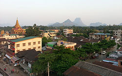
Hpa-an (Burmese: ဘားအံမြို့, [pʰə ʔàɰ̃ mjo̰]; Eastern Pwo: ဍုံထ်ုအင်; S'gaw Karen: ဖၣ်အၣ်ဝ့ၢ်ဖိ, also spelled Pa-an) is the capital and largest city of Kayin State (Karen State), Myanmar (Burma). The population of Hpa-an as of the 2014 census was 421,575. Most of the people in Hpa-an are of the Karen ethnic group.
Climate[]
Hpa-An has a tropical monsoon climate (Köppen climate classification Am). Temperatures are very warm throughout the year, although maximum temperatures are somewhat depressed in the monsoon season due to heavy cloud and rain. There is a winter dry season (November–April) and a summer wet season (May–October). Torrential rain falls from June to September, with over 1,100 millimetres (43 in) falling in July and August alone.
| hideClimate data for Hpa-An (1981–2010) | |||||||||||||
|---|---|---|---|---|---|---|---|---|---|---|---|---|---|
| Month | Jan | Feb | Mar | Apr | May | Jun | Jul | Aug | Sep | Oct | Nov | Dec | Year |
| Average high °C (°F) | 33.8 (92.8) |
35.7 (96.3) |
37.1 (98.8) |
37.7 (99.9) |
33.7 (92.7) |
29.8 (85.6) |
29.1 (84.4) |
28.8 (83.8) |
30.9 (87.6) |
33.6 (92.5) |
33.9 (93.0) |
33.0 (91.4) |
33.1 (91.6) |
| Average low °C (°F) | 17.9 (64.2) |
19.3 (66.7) |
22.0 (71.6) |
24.6 (76.3) |
24.5 (76.1) |
23.8 (74.8) |
23.5 (74.3) |
23.5 (74.3) |
23.8 (74.8) |
23.9 (75.0) |
22.0 (71.6) |
18.6 (65.5) |
22.3 (72.1) |
| Average rainfall mm (inches) | 1.2 (0.05) |
3.6 (0.14) |
12.6 (0.50) |
45.7 (1.80) |
376.9 (14.84) |
872.4 (34.35) |
1,047.2 (41.23) |
1,097.2 (43.20) |
577.0 (22.72) |
193.1 (7.60) |
40.7 (1.60) |
16.3 (0.64) |
4,283.9 (168.66) |
| Source: Norwegian Meteorological Institute[2] | |||||||||||||
Transport[]
Air
Hpa-An was linked to Yangon, Mawlamyine and by air but the airport ceased operations.
Buses
There are express buses from Hpa-An to Yangon, Mawlamyine, the border crossing at Myawaddy and other towns.
Population history[]
- 1953: 4,100
- 1983: 41,500
- 2014: 421,525
Education[]
Religion[]
The majority of residents are Theravada Buddhists, followed by Baptist, Anglican and Roman Catholic Christians.
Sights[]


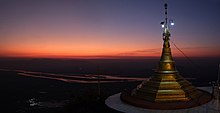
Kayin State Cultural Museum is located in Hpa-An. Zwegabin Hill is an attractive place for visitors, as well as Kyauk Ka Lat Pagoda in which the sacred hair relic of Buddha is enshrined. Hpa An is famous for many limestone caves, like (1) Bayin Nyi Naung Cave, (2) Yathae Byan Cave, (3) Kawtgon Cave (or Kawgoon Cave), (4) Kaw-ka-thaung Cave and (5) Saddan Cave. Such caves are well worth visiting because of their incredibly beautiful landscapes and ancient Buddha images and other cultural items in them which are once less known due to regional instability. Shwe Yin Hmyaw Pyi Taw Aye Pagoda is located at the heart of Pha An. Enjoying the beauty of Than Lwin River from the platform of the pagoda is an opportunity which should not be missed. Other interesting places are Kyone-Htaw waterfall which is 2 hours driving from Hpa-an, and the Saddan Cave (mentioned above) which is the biggest and longest cave in Kayin State.[3]
Health care[]
- Hpa-An General Hospital
- Taung Kalay Military Hospital
Sports[]
Football[]
Zwegabin United FC founded in 2010, is based in Hpa-An. The club is competing in Myanmar National League.
Trekking and hiking[]

Mount Zwegabin is around 8.5 km south of Hpa An. It is famous among tourists for its stunning view and beautiful green nature.[4]
At Bayint Nyi cave (literally: "King's Younger Brother cave"), a new climbing site has been developed primarily under the guidance of Andrew Riley & Katie Riley, as well as early support from The Technical Climbing Club of Myanmar (TCCM). This is an ongoing project having started in 2015 with support mostly coming from a growing number of expats in Yangon who belong to Myanmar Rock Community (MRC). The club is now beginning to attract interest from local people which is helping fuel a growing interest in the sport of rock climbing around Myanmar.[5] [6]
References[]
- ^ "Myanmar Area Codes". Archived from the original on 2009-12-01. Retrieved 2009-04-10.
- ^ "Myanmar Climate Report" (PDF). Norwegian Meteorological Institute. pp. 23–36. Archived from the original (PDF) on 8 October 2018. Retrieved 28 October 2018.
- ^ http://myanmarcaves.wikidot.com/saddan-hai-sin-caves-hpa-an
- ^ "The Ultimate Backpacking Experience". 2016-08-21. Retrieved 2018-05-30.
- ^ https://www.facebook.com/climbmyanmar/?ref=ts&fref=ts
- ^ https://www.mountainproject.com/v/hpa-an/110521642
External links[]
| hide | ||
|---|---|---|
Capital: Hpa-an | ||
| Hpa-an District |  | |
| Hpapun District | ||
| Kawkareik District | ||
| Myawaddy District | ||
| Cities and towns |
| |
| show Authority control |
|---|
- Township capitals of Myanmar
- Populated places in Kayin State