Huércal-Overa
Huércal-Overa, Spain | |
|---|---|
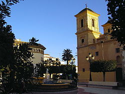 View of Huércal-Overa | |
 Flag  Coat of arms | |
| Coordinates: 37°23′N 1°56′W / 37.383°N 1.933°WCoordinates: 37°23′N 1°56′W / 37.383°N 1.933°W | |
| Country | Spain |
| Community | Andalusia |
| Municipality | Almería |
| Government | |
| • Mayor | Francisca Lourdes Fernández Ortega (PSOE) |
| Area | |
| • Total | 318 km2 (123 sq mi) |
| Elevation | 280 m (920 ft) |
| Population (2018)[1] | |
| • Total | 18,816 |
| • Density | 59/km2 (150/sq mi) |
| Time zone | UTC+1 (CET) |
| • Summer (DST) | UTC+2 (CEST) |

Huércal-Overa is a village and a municipality of Almería province, in the autonomous community of Andalusia, Spain, located near the border with the province of Murcia. The population of Huércal-Overa in 2014 was 18, 374. Huércal-Overa is situated in the Valley of Almanzora and its main economic sources have to do with agricultural activities. It is the main town of Levante Almeriense shire. It celebrates its yearly fair on the 3rd weekend of October.
In the last few years,[when?] this town has become a favourite target spot both for European and Latin American immigrants.[citation needed]
Demographics[]
| Year | Pop. | ±% |
|---|---|---|
| 1900 | 15,763 | — |
| 1999 | 13,870 | −12.0% |
| 2000 | 13,999 | +0.9% |
| 2001 | 14,293 | +2.1% |
| 2002 | 14,672 | +2.7% |
| 2003 | 15,059 | +2.6% |
| 2004 | 15,540 | +3.2% |
| 2005 | 16,156 | +4.0% |
| 2006 | 16,170 | +0.1% |
| 2007 | 16,360 | +1.2% |
| 2008 | 16,834 | +2.9% |
| 2009 | 17,645 | +4.8% |
| 2010 | 18,278 | +3.6% |
| 2011 | 18,580 | +1.7% |
| 2012 | 18,686 | +0.6% |
| 2013 | 18,925 | +1.3% |
| 2014 | 18,374 | −2.9% |
| Source: . Encyclopædia Britannica. 13 (11th ed.). 1911. p. 854. and INE (Spain) | ||
High schools[]
Nowadays, this town has two secondary schools: IES Cura Valera and IES Albujaira
References[]
- ^ Municipal Register of Spain 2018. National Statistics Institute.
External links[]
- (in Spanish) Huércal-Overa - Sistema de Información Multiterritorial de Andalucía
- (in Spanish) Huércal-Overa - Diputación Provincial de Almería
- (in Spanish) Villa de Huércal-Overa - Visita toda su gastronomía, fotos, foros deportes
| show Municipalities of the province of Almería |
|---|
| show Authority control |
|---|
This article about a location in the province of Almería, Spain, is a stub. You can help Wikipedia by . |
- Municipalities in the Province of Almería
- Province of Almería geography stubs