Huacramarca
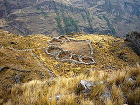
 View of Huacramarca. | |
 Shown within Peru | |
| Location | Ancash |
|---|---|
| Coordinates | 9°10′32″S 77°26′00″W / 9.1754411°S 77.4332291°WCoordinates: 9°10′32″S 77°26′00″W / 9.1754411°S 77.4332291°W |
Huacramarca[1][2] or Waqramarka[3] (possibly from Quechua waqra horn, marka village)[4] is an archaeological site on a mountain of the same name in Peru. Huacramarca lies southeast of Contrahierbas, near the village Huallin (located in the Ancash Region, Asunción Province, Chacas District).[1][3] The ruins are situated on top of the mountain Huacramarca at an elevation of 4,150 metres (13,615 ft).[1]
Images[]

Huacramarca with the Cordillera Blanca and the mountains Hualcán and Contrahierbas in the background
References[]
- ^ a b c Rafael Vega-Centeno, El Proyecto de Investigación Arqueológica Huacramarca. Resultados preliminares. investigaciones sociales Año XII N° 21, pp. 49-75 [unmsm / iihs, Lima, 2008] (in Spanish)
- ^ Ravines, Roger (1996). Atlas geográfico histórico del Perú (in Spanish). Editorial Brasa. p. 28. ISBN 9788483891735.
- ^ a b Herrera, Alexander; Orsini, Carolina; Lane, Kevin (2006). La complejidad social en la Sierra de Ancash: ensayos sobre paisaje, economía y continuidades culturales (in Spanish). Civiche Raccolte d'Arte Aplicada del Castello Sforzesco. p. 179.
- ^ Teofilo Laime Ajacopa, Diccionario Bilingüe Iskay simipi yuyayk'ancha, La Paz, 2007 (Quechua-Spanish dictionary): waqra - s. Cuerno. marka - s. Pueblo o aldea.
Categories:
- Archaeological sites in Peru
- Mountains of Peru
- Archaeological sites in Ancash Region
- Mountains of Ancash Region
- Ancash Region geography stubs

