Hukeng, Fujian
Hukeng
湖坑鎮 | |
|---|---|
Town | |
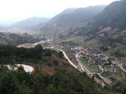 Nanjiang Village, a section of the "Great Wall of Tulou" in the Nanxi Valley | |
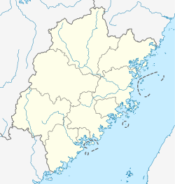 Hukeng Location in Fujian | |
| Coordinates: 24°39′00″N 116°57′00″E / 24.65000°N 116.95000°ECoordinates: 24°39′00″N 116°57′00″E / 24.65000°N 116.95000°E | |
| Country | People's Republic of China |
| Province | Fujian |
| Prefecture-level city | Longyan |
| County | Yongding |
| Area | |
| • Total | 95 km2 (37 sq mi) |
| Population (1997) | |
| • Total | 24,000 |
| http://www.xzqh.org/html/2008/1217/9544.html | |
| Time zone | UTC+8 (China Standard) |

Hukeng (Chinese: 湖坑) is a town (a township-level division) situated in Yongding County, Longyan, Fujian, China.[1]
A large number of Fujian Tulou are located with the territory administratively included within Hukeng, with a few within the actual Hukeng Town area. In particular, administratively, Hukeng includes the valley of the Nanxi (南溪, "South Creek"), where several villages (Yangduo, Xinnan, Nanzhong, Nanjiang, Shijia) consisting mostly of tulou form what some writers have dubbed the "Nanxi Great Wall of Tulou".
See also[]
References[]
| Wikimedia Commons has media related to Hukeng. |
- ^ "湖坑镇 (Hukeng Town)" (in Chinese). xzqh.org. Archived from the original on 2011-09-21. Retrieved 2012-05-24.
This Fujian location article is a stub. You can help Wikipedia by . |
Categories:
- Township-level divisions of Fujian
- Fujian geography stubs