Humacao barrio-pueblo
Humacao barrio-pueblo
Barrio Pueblo Humacao | |
|---|---|
Municipality Seat[1] | |
 Fountain at the main square in Humacao barrio-pueblo | |
 Location of Humacao barrio-pueblo within the municipality of Humacao shown in red | |
 Humacao barrio-pueblo Location of Puerto Rico | |
| Coordinates: 18°09′07″N 65°49′28″W / 18.152051°N 65.824325°WCoordinates: 18°09′07″N 65°49′28″W / 18.152051°N 65.824325°W[2] | |
| Commonwealth | |
| Municipality | |
| Area | |
| • Total | 0.64 sq mi (1.7 km2) |
| • Land | 0.64 sq mi (1.7 km2) |
| • Water | 0 sq mi (0 km2) |
| Elevation | 66 ft (20 m) |
| Population (2010) | |
| • Total | 3,862 |
| • Density | 6,034.4/sq mi (2,329.9/km2) |
| Source: 2010 Census | |
| Time zone | UTC−4 (AST) |
| ZIP Code | 00791 |

Humacao barrio-pueblo is a barrio and the administrative center (seat) of Humacao, a municipality of Puerto Rico. Its population in 2010 was 3,862.[1][4][5][6]
As was customary in Spain, in Puerto Rico, the municipality has a barrio called pueblo which contains a central plaza, the municipal buildings (city hall), and a Catholic church. Fiestas patronales (patron saint festivals) are held in the central plaza every year.[7][8]
| Historical population | |||
|---|---|---|---|
| Census | Pop. | %± | |
| 1980 | 6,275 | — | |
| 1990 | 5,551 | −11.5% | |
| 2000 | 4,787 | −13.8% | |
| 2010 | 3,862 | −19.3% | |
| U.S. Decennial Census[9] 1899 (shown as 1900)[10] 1910-1930[11] 1930-1950[12] 1980-2000[13] 2010[14] | |||
The central plaza history[]

The central plaza, or square, is a place for official and unofficial recreational events and a place where people can gather and socialize from dusk to dawn. The Laws of the Indies, Spanish law, which regulated life in Puerto Rico in the early 19th century, stated the plaza's purpose was for "the parties" (celebrations, festivities) (Spanish: a propósito para las fiestas), and that the square should be proportionally large enough for the number of neighbors (Spanish: grandeza proporcionada al número de vecinos). These Spanish regulations also stated that the streets nearby should be comfortable portals for passersby, protecting them from the elements: sun and rain.[7]
Gallery[]
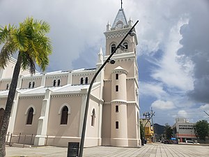
Dulce Nombre de Jesús Cathedral of Humacao in 2020.

Downtown Humacao skyline from the city hall, 2007.

Historic Casa Roig in downtown Humacao.

Teatro Victoria (Victoria Theater) on the western edge of the main plaza or square.
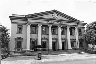
Old city hall of Humacao, now the district court.


See also[]
References[]
- ^ Jump up to: a b Puerto Rico:2010:population and housing unit counts.pdf (PDF). U.S. Dept. of Commerce, Economics and Statistics Administration, U.S. Census Bureau. 2010.
- ^ Jump up to: a b "US Gazetteer 2019". US Census. US Government.
- ^ U.S. Geological Survey Geographic Names Information System: Humacao barrio-pueblo
- ^ Picó, Rafael; Buitrago de Santiago, Zayda; Berrios, Hector H. Nueva geografía de Puerto Rico: física, económica, y social, por Rafael Picó. Con la colaboración de Zayda Buitrago de Santiago y Héctor H. Berrios. San Juan Editorial Universitaria, Universidad de Puerto Rico,1969.
- ^ Gwillim Law (20 May 2015). Administrative Subdivisions of Countries: A Comprehensive World Reference, 1900 through 1998. McFarland. p. 300. ISBN 978-1-4766-0447-3. Retrieved 25 December 2018.
- ^ "US Census Barrio-Pueblo definition". factfinder.com. US Census. Archived from the original on 13 May 2017. Retrieved 5 January 2019.
- ^ Jump up to: a b Santullano, Luis A. (10 March 2019). Mirada al Caribe. 54. Colegio de Mexico. pp. 75–78. doi:10.2307/j.ctvbcd2vs.12. JSTOR j.ctvbcd2vs.12.
- ^ Pariser, Harry S. (2003). Explore Puerto Rico, Fifth Edition. San Francisco: Manatee Press. pp. 52–55. Retrieved 10 February 2019.
- ^ "U.S. Decennial Census". United States Census Bureau. Archived from the original on February 13, 2020. Retrieved September 21, 2017.
- ^ "Report of the Census of Porto Rico 1899". War Department Office Director Census of Porto Rico. Archived from the original on July 16, 2017. Retrieved September 21, 2017.
- ^ "Table 3-Population of Municipalities: 1930 1920 and 1910" (PDF). United States Census Bureau. Archived (PDF) from the original on August 17, 2017. Retrieved September 21, 2017.
- ^ "Table 4-Area and Population of Municipalities Urban and Rural: 1930 to 1950" (PDF). United States Census Bureau. Archived (PDF) from the original on August 30, 2015. Retrieved September 21, 2014.
- ^ "Table 2 Population and Housing Units: 1960 to 2000" (PDF). United States Census Bureau. Archived (PDF) from the original on July 24, 2017. Retrieved September 21, 2017.
- ^ Puerto Rico:2010:population and housing unit counts.pdf (PDF). U.S. Dept. of Commerce Economics and Statistics Administration U.S. Census Bureau. 2010. Archived (PDF) from the original on 2017-02-20. Retrieved 2019-08-02.
External links[]
| hide Authority control | |
|---|---|
| General | |
| National libraries | |
This Humacao, Puerto Rico location article is a stub. You can help Wikipedia by . |
- Barrios of Humacao, Puerto Rico
- Puerto Rico Senatorial district VII geography stubs