Huntington, Massachusetts
Huntington | |
|---|---|
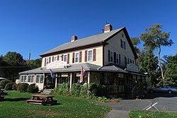 Huntington Country Store | |
 Seal | |
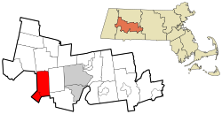 Location in Hampshire County in Massachusetts | |
| Coordinates: 42°14′10″N 72°52′35″W / 42.23611°N 72.87639°WCoordinates: 42°14′10″N 72°52′35″W / 42.23611°N 72.87639°W | |
| Country | United States |
| State | Massachusetts |
| County | Hampshire |
| Settled | 1769 |
| Incorporated (Norwich) | 1775 |
| Incorporated (Huntington) | March 5, 1855 |
| Government | |
| • Type | Open town meeting |
| Area | |
| • Total | 26.8 sq mi (69.4 km2) |
| • Land | 26.3 sq mi (68.2 km2) |
| • Water | 0.5 sq mi (1.2 km2) |
| Elevation | 382 ft (116 m) |
| Population (2010) | |
| • Total | 2,180 |
| • Density | 83/sq mi (32.0/km2) |
| Time zone | UTC-5 (Eastern) |
| • Summer (DST) | UTC-4 (Eastern) |
| ZIP Code | 01050 |
| Area code(s) | 413 |
| FIPS code | 25-31785 |
| GNIS feature ID | 0618203 |
| Website | www |

Huntington is a town in Hampshire County, Massachusetts, United States. The population was 2,180 at the 2010 census.[1] It is part of the Springfield, Massachusetts Metropolitan Statistical Area.
History[]
This section does not cite any sources. (August 2017) |

Originally Plantation Number 9 by the Court of Massachusetts Bay, Huntington has a colorful history, hinted at by the town's incorporation date of March 5, 1855, decades later than the towns around it. The town was assembled from pieces of surrounding towns, which were grafted onto the towns of Norwich, Murrayfield, and Knightville. The present village center sits on what was the meeting point of three towns and two counties. The location of the village created a tangle of jurisdictional confusion. With the coming of the railroad in the 1840s and the expansion of industry and population that came with it, the political difficulties that the boundaries presented became untenable.
The solution that resulted in the present town was crafted by a Northampton attorney named Charles Huntington. Once the new town was incorporated, Mr. Huntington presented it with a gift that was the foundation of the town's library. After some discussion, the newly formed town voted to adopt the name of "Huntington", in honor of its recent architect and benefactor.
Geography[]
Huntington is in southwestern Hampshire County, bordered to the south and west by towns in Hampden County. The Westfield River runs through the town, joined by its West Branch at the village of Huntington in the southern part of the town. U.S. Route 20 follows the lower Westfield River and its West Branch through the town, leading southeast 12 miles (19 km) to the city of Westfield and northwest 23 miles (37 km) to Lee.
According to the United States Census Bureau, the town of Huntington has a total area of 26.8 square miles (69.4 km2), of which 26.3 square miles (68.2 km2) are land and 0.46 square miles (1.2 km2), or 1.78%, are water.[1]
Demographics[]
As of the census[11] of 2000, there were 2,174 people, 809 households, and 597 families residing in the town. The population density was 81.6 people per square mile (31.5/km2). There were 935 housing units at an average density of 35.1 per square mile (13.6/km2). The racial makeup of the town was 97.56% White, 0.41% African American, 0.18% Native American, 0.41% Asian, 0.28% from other races, and 1.15% from two or more races. Hispanic or Latino of any race were 1.84% of the population.
There were 809 households, out of which 35.0% had children under the age of 18 living with them, 60.4% were married couples living together, 8.9% had a female householder with no husband present, and 26.2% were non-families. 19.2% of all households were made up of individuals, and 6.8% had someone living alone who was 65 years of age or older. The average household size was 2.69 and the average family size was 3.10.
In the town, the population was spread out, with 27.7% under the age of 18, 6.4% from 18 to 24, 30.0% from 25 to 44, 26.1% from 45 to 64, and 9.7% who were 65 years of age or older. The median age was 37 years. For every 100 females, there were 98.5 males. For every 100 females age 18 and over, there were 98.2 males.
The median income for a household in the town was $48,958, and the median income for a family was $52,308. Males had a median income of $36,893 versus $27,414 for females. The per capita income for the town was $19,385. About 4.4% of families and 5.8% of the population were below the poverty line, including 6.2% of those under age 18 and 10.7% of those age 65 or over.
See also[]
References[]
- ^ Jump up to: a b "Geographic Identifiers: 2010 Census Summary File 1 (G001): Huntington town, Hampshire County, Massachusetts". American Factfinder. U.S. Census Bureau. Archived from the original on February 13, 2020. Retrieved August 8, 2017.
- ^ "TOTAL POPULATION (P1), 2010 Census Summary File 1, All County Subdivisions within Massachusetts". United States Census Bureau. Archived from the original on February 12, 2020. Retrieved September 13, 2011.
- ^ "Massachusetts by Place and County Subdivision – GCT-T1. Population Estimates". United States Census Bureau. Archived from the original on November 3, 2011. Retrieved July 12, 2011.
- ^ "1990 Census of Population, General Population Characteristics: Massachusetts" (PDF). US Census Bureau. December 1990. Table 76: General Characteristics of Persons, Households, and Families: 1990. 1990 CP-1-23. Archived from the original (PDF) on December 7, 2013. Retrieved July 12, 2011.
- ^ "1980 Census of the Population, Number of Inhabitants: Massachusetts" (PDF). US Census Bureau. December 1981. Table 4. Populations of County Subdivisions: 1960 to 1980. PC80-1-A23. Retrieved July 12, 2011.
- ^ "1950 Census of Population" (PDF). 1: Number of Inhabitants. Bureau of the Census. 1952. Section 6, Pages 21-10 and 21-11, Massachusetts Table 6. Population of Counties by Minor Civil Divisions: 1930 to 1950. Retrieved July 12, 2011. Cite journal requires
|journal=(help) - ^ "1920 Census of Population" (PDF). Bureau of the Census. Number of Inhabitants, by Counties and Minor Civil Divisions. Pages 21-5 through 21-7. Massachusetts Table 2. Population of Counties by Minor Civil Divisions: 1920, 1910, and 1920. Retrieved July 12, 2011.
- ^ "1890 Census of the Population" (PDF). Department of the Interior, Census Office. Pages 179 through 182. Massachusetts Table 5. Population of States and Territories by Minor Civil Divisions: 1880 and 1890. Retrieved July 12, 2011.
- ^ "1870 Census of the Population" (PDF). Department of the Interior, Census Office. 1872. Pages 217 through 220. Table IX. Population of Minor Civil Divisions, &c. Massachusetts. Retrieved July 12, 2011.
- ^ "1860 Census" (PDF). Department of the Interior, Census Office. 1864. Pages 220 through 226. State of Massachusetts Table No. 3. Populations of Cities, Towns, &c. Retrieved July 12, 2011.
- ^ "U.S. Census website". United States Census Bureau. Retrieved 2008-01-31.
External links[]
| Wikimedia Commons has media related to Huntington, Massachusetts. |
- Town of Huntington official website
- Huntington Police Department
- Huntington Public Library
- Gateway Regional School District
- MHC Survey Reconnaissance Town Report: Huntington' Massachusetts Historical Commission, 1982.
- Huntington Vision: Huntington Community Development Plan Pioneer Valley Planning Commission, 2003.
| show Municipalities and communities of Hampshire County, Massachusetts, United States |
|---|

| Authority control |
|
|---|
- Towns in Hampshire County, Massachusetts
- Springfield metropolitan area, Massachusetts
- Towns in Massachusetts