Ignalina District Municipality
Ignalina District Municipality
Ignalinos rajono savivaldybė | |
|---|---|
Municipality | |
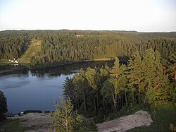 Žaliasis lake | |
 Coat of arms | |
 Location of Ignalina district municipality within Lithuania | |
| Coordinates: 55°20′52″N 26°14′27″E / 55.34778°N 26.24083°ECoordinates: 55°20′52″N 26°14′27″E / 55.34778°N 26.24083°E | |
| Country | |
| Ethnographic region | Aukštaitija |
| County | |
| Capital | Ignalina |
| Elderships | 12 |
| Area | |
| • Total | 1,447 km2 (559 sq mi) |
| Area rank | 18th |
| Population (2021) | |
| • Total | 14,125 |
| • Rank | 54th |
| • Density | 9.76/km2 (25.3/sq mi) |
| • Density rank | 59th |
| Time zone | UTC+2 (EET) |
| • Summer (DST) | UTC+3 (EEST) |
| Telephone code | 386 |
| Major settlements |
|
| Website | www |

Ignalina District Municipality is one of 60 municipalities in Lithuania.[1]
Structure[]
District structure:
- 2 cities – Dūkštas and Ignalina;
- 3 towns – Mielagėnai, Rimšė and Tverečius;
- 726 villages.
- Ignalina District Municipality consists of 12 smaller administration units - elderships.
Population of largest Ignalina District Municipality elderships (2014-07-01):
- Ignalina town – 5605
- Didžiasalis – 1691
- Vidiškės – 1278
- Dūkštas – 1756
- Kazitiškis – 1039
- – 1491
- Mielagėnai – 887
- Ceikiniai – 533
- Linkmenys – 970
- Rimšė – 999
- Tverečius – 590
In total - 18414 inhabitants.
Nature and geography[]
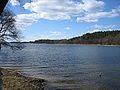

Rock of
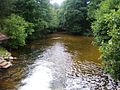
The river


See also[]
References[]
| Authority control |
|
|---|
This Lithuanian location article is a stub. You can help Wikipedia by . |
Categories:
- Ignalina District Municipality
- Municipalities of Utena County
- Municipalities of Lithuania
- Lithuania geography stubs