Ilhéu de Cima
 Ilhéu de Cima | |
 | |
 Ilhéu de Cima | |
| Geography | |
|---|---|
| Location | Atlantic Ocean |
| Coordinates | 14°58′16″N 24°38′17″W / 14.971°N 24.638°WCoordinates: 14°58′16″N 24°38′17″W / 14.971°N 24.638°W |
| Total islands | 3 |
| Area | 1.5 km2 (0.58 sq mi) |
| Length | 2.2 km (1.37 mi) |
| Width | 0.94 km (0.584 mi) |
| Highest elevation | 77 m (253 ft) |
| Administration | |
| Concelhos (Municipalities) | Brava |
| Demographics | |
| Population | 0 |


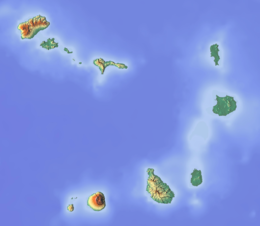
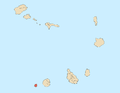
Ilhéu de Cima is an uninhabited island of Cape Verde. It is part of the Ilhéus do Rombo islet group, located 4 kilometres (2.5 mi) east of Ilhéu Grande, the other main islet of the group, and 8 kilometres (5.0 mi) northeast of the island Brava. They are administratively a part of the Brava municipality. Surrounding islets include Ilhéu Luiz Carneiro, Ilhéu Sapado, and Ilhéu do Rei. The island is part of the integral nature reserve Ilhéus do Rombo,[1] famous for its seabird colonies.[2]
The southern part of the islet is the highest, culminating at 77 metres (253 ft).[3] This is where the Ilhéu de Cima Lighthouse is situated,[4] the only building on the island. The islet was mentioned as "Ghuay" in the 1747 map by Jacques-Nicolas Bellin.[5]
Notable endemic fauna found on the island include the Iago sparrow. In the mid-1950s, W. R. P. Bourne observed females remaining in flocks while males began to take up locations on rocky slopes from which they could sing.[6] A species of sponge Esperiopsis cimensis was found in the deep waters surrounding the islet.[7]
See also[]
References[]
- ^ "Nature reserves of Cape Verde" (PDF).
- ^ birdlife.org
- ^ Sailing Directions (Enroute), Pub. 143: West Coast of Europe and Northwest Africa (PDF). Sailing Directions. United States National Geospatial-Intelligence Agency. 2017. p. 247.
- ^ List of Lights, Pub. 113: The West Coasts of Europe and Africa, the Mediterranean Sea, Black Sea and Azovskoye More (Sea of Azov) (PDF). List of Lights. United States National Geospatial-Intelligence Agency. 2018. p. 428.
- ^ Jacques-Nicolas Bellin (1747). "Carte des Isles du Cap Verd = Kaart van de Eilanden van Kabo Verde" (in French).
- ^ Bourne, W. R. P. (1955). "The Birds of the Cape Verde Islands". Ibis. 97 (3): 508–556. doi:10.1111/j.1474-919X.1955.tb04981.x.
- ^ van Soest, Rob W. M., Elly J. Beglinger & Nicole J. De Voogd, 2012: Sponges of the family Esperiopsidae (Demospongiae, Poecilosclerida) from northwest Africa. European journal of taxonomy, 18: 1–21.
- Islands of Cape Verde
- Uninhabited islands of Cape Verde
- Protected areas of Cape Verde
- Brava Municipality