Imber
| Imber | |
|---|---|
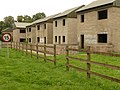
 Part of the Urban warfare training area at Imber; original dwellings in centre | |
 Imber Location within Wiltshire | |
| Population | 0 |
| OS grid reference | ST965485 |
| Civil parish | |
| Unitary authority | |
| Ceremonial county | |
| Region | |
| Country | England |
| Sovereign state | United Kingdom |
| Post town | DEVIZES |
| Postcode district | SN10 |
| Police | Wiltshire |
| Fire | Dorset and Wiltshire |
| Ambulance | South Western |
| UK Parliament | |

Imber is an uninhabited village in part of the British Army's training grounds on the Salisbury Plain, Wiltshire, England. It is situated in an isolated area of the Plain, about 2+1⁄2 miles (4 km) west of the A360 road between Tilshead and West Lavington. The entire civilian population was evicted in 1943 to provide an exercise area for American troops preparing for the invasion of Europe during the Second World War.
After the war, villagers were not allowed to return to their homes. The village, which is now part of the civil parish of Heytesbury, remains under the control of the Ministry of Defence despite several attempts by former residents to return. Non-military access is limited to several open days a year.[1]
History[]
Early history[]
Settlement in the area began before the period of Roman rule, in the British Iron Age or earlier. Several ancient trackways lead to and from the village. The first documentary evidence of Imber's existence comes from Saxon times, with a mention of the village in 967. Imber is also recorded in the Domesday Book, at which time it is believed to have had a population of around 50. The village's church of St Giles dates from the 13th century and has notable wall-paintings from the 15th. By the 14th century the population of the village had risen to around 250, where it is believed to have remained until the 19th century. Population peaked at 440 as recorded in the census of 1851, declining to around 150 by the time of Imber's abandonment.

Imber was always an isolated community, Salisbury Plain being relatively sparsely populated, and most of its residents were employed in agriculture or work that directly depended on it.[2] The village had the elongated form of a linear village, and its main street followed the course of a stream known as Imber Dock. The only building to survive in a reasonable condition is the church; the rest became derelict or were demolished by the Army. In 1943 there was also a Baptist chapel (built in 1839, demolished in late 1970s), a post office, and a pub called the Bell Inn, which still stands; as does the manor house, Imber Court and a farmhouse, farm cottages, schoolroom and four "council house" type blocks built in 1938.
Eviction and military use[]
In the late 19th century the War Office began buying land on Salisbury Plain, primarily to the east of Imber, and using it for manœuvres. Beginning in the late 1920s, farms around Imber were bought, as well as the land on which the village sat. The pressures of agricultural depression, combined with the good prices offered by the military, encouraged the sale of land, with few being put off by the new conditions of their tenancy. This allowed the War Office to assume control and evict the residents if necessary. By the time of the Second World War, almost all of the land in and around Imber, except the church, vicarage, chapel, schoolroom and Bell Inn, belonged to the War Office.
On 1 November 1943, with preparations for the Allied invasion of mainland Europe under way, the people of Imber were called to a meeting in the village schoolroom and given 47 days' notice to leave their homes; Imber was to be used by US forces to practise street fighting. Richard Madigan's evidence to the Defence Lands Committee (DLC) stated that street fighting practise never took place and that his, and others', duties were to keep the village in good repair for the villagers' eventual return. The reason for eviction was the village's proximity to shell impact areas.

Although upset about being forced to leave, most villagers put up no resistance, even leaving canned provisions in their kitchens and taking the view that it was their duty to contribute to the war effort in this way – making sacrifices on the Home Front for the greater good. Compensation for the move was limited, and the occupants of one farm had to be forcibly evicted by the Army. Albert Nash, who had been the village blacksmith for over 40 years, is said to have been found sobbing over his anvil and later became the first resident to die and be brought back to Imber for burial.[3] It was said that he died of a broken heart after being forced to leave the village.[4]
After the war, the village was used extensively for training, particularly preparing soldiers for service in the urban environments of Northern Ireland during The Troubles, and several empty house-like buildings were constructed during the 1970s to aid training. Since 1988, urban warfare training has been centred at a purpose-built complex at Copehill Down, about 3 miles to the southeast.
Restoration attempts[]
Many of the village's buildings suffered shell and explosion damage after the war when UK military operations began, and, additionally eroded by the weather, quickly fell into disrepair. Although the villagers had been told they could return in six months, this was never allowed. Documentary evidence of a return agreement was only discovered at the Defence Land Committee hearings.[clarification needed] At the end of the war, efforts were made to restore Imber to its pre-war condition – although there was very little damage – but the decision was taken not to relinquish control.
A rally in the village was organised in 1961 to demand that the villagers be allowed to move back, and over 2,000 people attended, including many former residents. A public inquiry was held, and found in favour of Imber's continued military use.[5]
The matter was also raised in the House of Lords, and it was decided that the church would be maintained, and would be open for worship on the Saturday closest to St Giles' Day each year, a practice that continues.
A further attempt to restore Imber took place in the early 1970s when the Defence Lands Committee (DLC) was given the task of looking into the need for the retention of Ministry of Defence lands. The Imber case was represented before the DLC by David J. Johnson, an Imber researcher; Richard Madigan, a former soldier who helped to evacuate the village – and testified to the promise of return after the war – and Rex Mutters, a wartime fighter pilot.[6] They were assisted by Austin Underwood, who had led the campaign in the early 1960s and backed-up with written evidence from former villagers. In spite of all the additional evidence, including the first re-appearance since 1943 of the original eviction letter (which indicated return),[7] the DLC recommended that the village be retained for military use.[8]
Present day[]
The annual church service, on the Saturday nearest to 1 September (St Giles' Day), has been attended by former residents including Ken Mitchell (grandson of Albert Nash); the son of the last schoolmistress, John Williams; soldiers who have used the village for training, and the general public. The village is open to visitors on other occasions: generally, these are certain bank holidays and around Christmas. Since 2009 there has been a carol service on the Saturday before Christmas.
Since 2009, the annual summer opening of the village has been served by preserved and new double-decker buses, many originally from London. These operate to a scheduled public timetable, not as excursions, and the village appears as a destination on the bus stop at Warminster railway station.[9]
St Giles' Parish Church[]

Unlike the rest of the parish, St Giles' church and its graveyard remained in the hands of the Diocese of Salisbury, although access was and is controlled by the Ministry of Defence. The Bell Inn was sold to the MoD in the mid-1950s and the Baptist Chapel in the late 1970s. The civil parish of Imber was eventually incorporated into neighbouring Heytesbury, to the south, while for Church of England purposes the ecclesiastical parish of Imber was incorporated into the parish of Edington, to the north. This combined ecclesiastical parish of Edington with Imber was responsible for another ancient listed church, Edington Priory, as well as St Giles'.
The church was recorded as Grade I listed in 1987.[10]
By 2001 it had become clear, according to a Church of England press release, that St Giles's "was in need of extensive repairs". Since it was "not possible for the parochial church council to accept liability for the maintenance of a building to which they only had effective access for worship once a year", the Edington with Imber PCC requested that Imber church be declared redundant, a process which ended in 2005 with the vesting of the church in the Churches Conservation Trust. In the meantime, the church tower had been struck by lightning in 2003, weakening the structure, but restoration work began in 2008 and the annual service resumed in September 2009 on completion of the works.
Census[]
Imber is still included in the census records for England. The population reached its peak of 440 in 1851 which had declined to 152 by 1931 when the last occupied census was taken. The next census after 1931 was in 1951 when the number of residents was listed as "0", a situation which continues to be shown on census results.[11]
Governance[]
The civil parish of Imber has been incorporated into the adjoining parish of Heytesbury. A parish council known as "Heytesbury, Imber and Knook" covers this parish and the neighbouring parish of Knook.[12] Although it has no electors, Imber is represented in parliament by the member for South West Wiltshire, Andrew Murrison; and on Wiltshire Council by Christopher Newbury.
With the exception of St Giles' church, the whole of the former parish is owned by the Ministry of Defence and is administered as part of its Salisbury Plain Training Area.
Popular culture[]
Imber features in the 1965 movie Catch Us If You Can, the debut feature film of director John Boorman and a starring vehicle for the British pop group The Dave Clark Five.
In Victor Canning's 1972 novel for teenagers The Runaways, the cheetah that has escaped from Longleat Safari Park makes a den on the firing range close to Imber and her cubs are found there by the young hero Smiler.[13]
A photograph taken in Imber is featured on the cover of These Four Walls, the 2009 debut album from Scottish indie rock band We Were Promised Jetpacks.
The 2013 novel The Sea Change by Joanna Rossiter centres on the evacuation of Imber, and the subsequent experiences of fictional characters from the village in the war and post-war years.[14]
Neil Spring's 2017 novel The Lost Village, a ghost story featuring ghost hunter Harry Price, is set in Imber.[15]
Imber features in the fourth episode of Michael Portillo's Channel 5 series Portillo's Hidden History of Britain broadcast 11 May 2018.[16]
Musical references[]
Mount Vernon Arts Lab recorded the instrumental piece Imber by Drew Mulholland and this was released on Earworm Subscription Series in 1998 (WORMSS2).
by the Georgian composer Giya Kancheli is a piece for small ensemble, voice, children's and men's choirs. It was performed in the church at Imber in 2003 and the recording released on ECM Records in 2008 (ECM 1812).
The Norwegian electronic duo Kook recorded an album called Imber, Wiltshire of seven wordless compositions all with titles taken from the village and its inhabitants. This was released on Va Fongool Records (VAFCD011).
The Wiltshire folk group The Yirdbards recorded their song The Ghosts of Old Imber at St Giles' Church in the village in October 2013 and released it on CD in 2014 to raise funds for the church.
Gallery[]


The former Seagrams Farm
Houses used for training purposes

This building was a pub known as The Bell

Imber Court building


Monument to victim of highwaymen, Imber Range


See also[]
- Imber friendly fire incident (1942)
- Tyneham – another village taken over for military purposes
- Langford, Norfolk
References[]
- ^ "The lost village of Imber". BBC. 10 September 2010.
- ^ "Imber". Abandonedcommunities.co.uk. Retrieved 20 August 2016.
- ^ Geoghegan, Tom (18 November 2010). "The secrets of Britain's abandoned villages". BBC News. Retrieved 20 August 2016.
- ^ Portillo's Hidden History of Britain, Channel Five, 11 May 2018
- ^ Sawyer 2001, pp. 145–152
- ^ Sawyer 2001, pp. 158–159
- ^ Sawyer 2001, pp. 158
- ^ Sawyer 2001, pp. 159
- ^ "Imberbus". Imberbus. Retrieved 17 August 2019.
- ^ Historic England. "Church of St Giles, Heytesbury (1036472)". National Heritage List for England. Retrieved 16 February 2015.
- ^ "Imber Census Information". Wiltshire Council. Retrieved 13 May 2013.
- ^ "Heytesbury Imber and Knook Parish Council". Wiltshire Council. Retrieved 11 March 2017.
- ^ Victor Canning (1972). The Runaways. Heinemann Educational. ISBN 978-0-435-12180-8.
- ^ Joanna Rossiter (2013). The Sea Change. Penguin Books Limited. ISBN 978-0-241-96416-3.
- ^ Neil Spring (19 October 2017). The Lost Village: The Ghost Hunters (2). Quercus. ISBN 978-1-78429-861-6.
- ^ "Portillo's Hidden History of Britain". Channel 5. Retrieved 13 May 2018.
Further reading[]
- Bodington, E.J. (1919). "The Church Survey in Wiltshire 1649–50". Wiltshire Archaeological and Natural History Magazine. 41: 23–5.
- Glanfield, Edgar (1922). "The Dew Pond Makers of Imber". Wiltshire Archaeological and Natural History Magazine. 42: 73–5.
- Kite, Edward (1920). "Imber and Imber Court". Wiltshire Archaeological and Natural History Magazine. 41: 212.
- Ponting, C.E. (1889). "Church of St. Giles, Imber". Wiltshire Archaeological and Natural History Magazine. 25: 13–15.
- Powell, J.U. (1918). "The Derivation of Imber". Wiltshire Archaeological and Natural History Magazine. 40: 362.
- Revels, G.S. (c. 1972) A Thousand years of History: a short guide to St Giles Church and the Parish of Imber.
- Rex L. Sawyer (2010) [2001]. Little Imber on the Down: Salisbury Plain's Ghost Village (reprint ed.). Hobnob Press. ISBN 978-1-906978-24-2.
External links[]
| Wikimedia Commons has media related to Imber. |
- Parish of Heytesbury, Imber, Knook and Tytherington
- St Giles Church
- Information about access to Imber from public-interest.co.uk
- Gallery of photos of Imber from ThincTanc
- Maps and photos of the church
- Etymology of the name
- 2003 arts event at Imber
- Review of the 2003 arts event at Imber in The Times
- Imber: An English Ghost Town — slideshow by Life magazine
- Audio slideshow: The lost village of Imber — audio slideshow by the BBC.
- Google Earth view
- Wiltshire County Council. "Wiltshire Community History: Imber". Retrieved 26 May 2005.
- BBC Wiltshire Villages. "The plight of the church at Imber". Retrieved 26 May 2005.
- World War II sites in England
- Villages in Wiltshire
- Military history of Wiltshire
- Installations of the British Army
- Former populated places in Wiltshire
- Ghost towns in England
- Former civil parishes in Wiltshire
- Forcibly depopulated communities in the United Kingdom during World War II