Inaccessible Island (Dellbridge Islands)
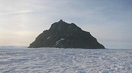 Inaccessible Island from the southeast. | |
 Location in Antarctica | |
| Geography | |
|---|---|
| Location | Antarctica |
| Coordinates | 77°40′S 166°22′E / 77.667°S 166.367°ECoordinates: 77°40′S 166°22′E / 77.667°S 166.367°E |
| Archipelago | Dellbridge Islands |
| Highest elevation | 95 m (312 ft) |
| Administration | |
| Administered under the Antarctic Treaty System | |
| Demographics | |
| Population | Uninhabited |

Inaccessible Island is a small rocky island, the northernmost of the Dellbridge Islands, lying 2 kilometres (1 nmi) southwest of Cape Evans, Ross Island, Antarctica. It is the most imposing of the group as it is nearly always bare of snow and rises to 95 meters (310 ft). The island was discovered by the British National Antarctic Expedition (1901–04) under Robert Falcon Scott and so named because of the difficulty in reaching it.[1][2]
See also[]
- Composite Antarctic Gazetteer
- List of Antarctic islands south of 60° S
- Scientific Committee on Antarctic Research
- Territorial claims in Antarctica
References[]
Citations[]
- ^ "Inaccessible Island". Geographic Names Information System. United States Geological Survey. Retrieved 2012-07-06.
- ^ Fletcher, Lazarus; Bell, Francis Jeffrey (1907). Natural history; Volume 1 of Natural History: Voyage of the S.S. Discovery Under Capt. R.F. Scott. University of California: British Museum (Natural History). p. 16.
Sources[]
 This article incorporates public domain material from the United States Geological Survey document: "Inaccessible Island". (content from the Geographic Names Information System)
This Ross Dependency location article is a stub. You can help Wikipedia by . |
Categories:
- Ross Archipelago
- Ross Dependency geography stubs