Incomappleux River
| Incomappleux River | |
|---|---|
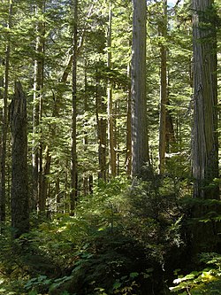 The inland temperate rainforest of the Incomappleux River Valley | |
 Location in British Columbia | |
| Location | |
| Country | Canada |
| Province | British Columbia |
| District | Kootenay Land District |
| Physical characteristics | |
| Source | Illecillewaet Neve |
| • location | Selkirk Mountains |
| Mouth | Columbia River |
• location | Upper Arrow Lake |
• coordinates | 50°45′N 117°43′W / 50.750°N 117.717°WCoordinates: 50°45′N 117°43′W / 50.750°N 117.717°W[1] |
| Basin size | 1,020 km2 (390 sq mi)[2] |
| Discharge | |
| • location | near Beaton[2] |
| • average | 55.8 m3/s (1,970 cu ft/s)[2] |
| • minimum | 4.76 m3/s (168 cu ft/s) |
| • maximum | 570 m3/s (20,000 cu ft/s) |
| Basin features | |
| Progression | Incomappleux Valley |

The Incomappleux River is a major tributary of the Columbia River in British Columbia, Canada, entering that river via the Beaton Arm of Upper Arrow Lake. The upper reaches of the river valley are home to a portion of the only inland temperate rainforest in the world.
First Nations[]
The name "Incomappleux" is derived from the Okanagan word nk'mapeleqs, meaning "point at end (of lake)". This refers to the northeastern tip of Upper Arrow Lake into which the Incomappleux River empties. The names of the creek and adjacent mountain are also derived from this word. A Sinixt village by this name formerly existed somewhere in the confluence area.[3]
European settlement[]
Early explorers referred to the valley and river as various English spellings of the word, but Fish River was also used.[3] The pioneer towns of Arrowhead, Beaton, Camborne, Circle City, and Comaplix were in the Beaton Arm area. The mines Eva, Oyster, Meridian, Silver Dollar and others were rich in silver lead ore.
Course[]
The river's course is nearly due south from its origin in the Selkirk Mountains at the southwest toe of the on Mount Bonney, which is on the south side of the Rogers Pass and is also the source of the Illecillewaet River. This wild outfall is amid large cedars, hemlock, devil's club and bears. owned the timber lease, and wanted to cut the prime cedar, there being a grove of spectacular thousand year old cedar in the area. P and T have since gone bankrupt and the road through the canyon by river has washed out.[citation needed]
See also[]
References[]
- ^ "Incomappleux River". BC Geographical Names.
- ^ Jump up to: a b c "Archived Hydrometric Data Search". Water Survey of Canada. Archived from the original on February 21, 2009. Retrieved October 19, 2008. Search for Station 08NE001 Incomappleux River near Beaton
- ^ Jump up to: a b "Nelson Star, 1 Dec 2013". www.nelsonstar.com.
External links[]
 Media related to Incomappleux River at Wikimedia Commons
- Tributaries of the Columbia River
- Arrow Lakes
- Columbia Country
- Rivers of British Columbia
- Kootenay Land District
- British Columbia Interior river stubs