Inkpen and Walbury Hills
| Site of Special Scientific Interest | |
 Walbury Hill | |
| Location | Berkshire |
|---|---|
| Grid reference | SU 363 621[1] |
| Interest | Biological |
| Area | 86.8 hectares (214 acres)[1] |
| Notification | 1983[1] |
| Location map | Magic Map |

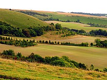
Inkpen and Walbury Hills is an 86.8-hectare (214-acre) biological Site of Special Scientific Interest south of Kintbury in Berkshire.[1][2] A Bronze Age cemetery of three bowl barrows on Inkpen Hill is designated a Scheduled Monument.[3]
These hills have the largest area of unimproved chalk downland in the county and much of it is managed by sheep grazing. North facing slopes have many mosses and herbs, such as hoary plantain and germander speedwell. There are also woods and hedgerows which provide a habitat for many species of breeding birds.[4]
See also[]
References[]
- ^ a b c d "Designated Sites View: Inkpen and Walbury Hills". Sites of Special Scientific Interest. Natural England. Retrieved 17 October 2019.
- ^ "Map of Inkpen and Walbury Hills". Sites of Special Scientific Interest. Natural England. Retrieved 17 October 2019.
- ^ "Round barrow cemetery on Inkpen Hill". Historic England. Retrieved 17 October 2019.
- ^ "Inkpen and Walbury Hills citation" (PDF). Sites of Special Scientific Interest. Natural England. Retrieved 17 October 2019.
| Wikimedia Commons has media related to Inkpen and Walbury Hills. |
Coordinates: 51°21′25″N 1°28′48″W / 51.357°N 1.480°W
Categories:
- Sites of Special Scientific Interest in Berkshire