Inner Distribution Road
| Inner Distribution Road | |
|---|---|
 Map of Reading Town Centre showing the Inner Distribution Road | |
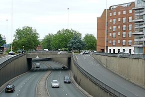 Junction with Chatham Street and Friar Street | |
| Route information | |
| Length | 2.4 mi (3.9 km) |
| Existed | 1969–present |
| Major junctions | |
| Orbital around Reading, Berkshire | |
| Road network | |
The Inner Distribution Road or IDR is a mostly dual carriageway ring road that encircles the town centre of Reading, Berkshire, England. It forms part of the A329 that runs from Wentworth in Surrey to Thame in Oxfordshire.
History[]
The Inner Distribution Road was proposed as a radical solution to the regular build up of traffic in the town centre, and the air and noise pollution that accompanied it. It opened in 1969, after much controversy because the route necessitated the destruction of several central Reading neighbourhoods. Due to unforeseen financial problems it remained incomplete until 1989.[1][2]
Future[]
Reading Borough Council drew up plans in 2006 for the Inner Distribution Road to become an anti-clockwise one-way traffic route to help the traffic keep moving.[3] In 2006 local radio station Reading 107 conducted a survey asking if the road should become a one-way system, over 90% of people thought that there should be a public enquiry before any proposed changes go ahead.[4] Plans have since been put on hold in 2010.[5]
Development plans created in 2003 to build a deck over the Inner Distribution Road to enable the expansion of were partially completed in 2009.[6] Speaking at an event to mark the completion of the Chatham Place redevelopment in February 2016, Tony Page, Deputy Leader of the Council, said "Part of our vision for this area is to one day cover over the IDR to shield off all of the noise; it is an aspiration that we intend to work on in the future."[7]
References[]
- ^ Phillips, Daphne (1980). The Story of Reading. Countryside Books. p. 168. ISBN 0-905392-07-8.
- ^ "Roads". Reading History Trail. Archived from the original on 2 February 2009. Retrieved 16 January 2015.
- ^ "One-way IDR map unveiled". Berkshire Live. In Your Area. 22 February 2006. Retrieved 5 September 2019.
{{cite web}}: CS1 maint: url-status (link) - ^ "107FM Reading Inner Distribution Road Survey". Business in Reading. Archived from the original on 21 July 2011. Retrieved 5 September 2019.
- ^ "Reading town centre revamp could be downsized". BBC News. 27 September 2010. Retrieved 19 April 2011.
- ^ "IDR decking plan to be shelved". Reading Post. Archived from the original on 24 September 2010. Retrieved 16 January 2014.
- ^ Perryman, Francesca (19 February 2016). "Cannon event marks the completion of Chatham Place Redevelopment". getreading. Retrieved 15 March 2016.
| Wikimedia Commons has media related to Inner Distribution Road. |
Coordinates: 51°27′16.25″N 0°58′44.04″W / 51.4545139°N 0.9789000°W

This England road or road transport-related article is a stub. You can help Wikipedia by . |
This Berkshire location article is a stub. You can help Wikipedia by . |
- Roads in Berkshire
- Geography of Reading, Berkshire
- Transport in Reading, Berkshire
- England road stubs
- Berkshire geography stubs