Interstate 5 in Oregon
 | ||||
|---|---|---|---|---|
| National Purple Heart Trail Korean War Veterans Memorial Highway | ||||
 Map of Western Oregon with I-5 highlighted in red | ||||
| Route information | ||||
| Maintained by ODOT | ||||
| Length | 308.14 mi[1] (495.90 km) | |||
| Existed | August 14, 1957[2][3]–present | |||
| History | Completed in 1966 | |||
| Major junctions | ||||
| South end | ||||
| North end | ||||
| Location | ||||
| Counties | Jackson, Josephine, Douglas, Lane, Linn, Marion, Clackamas, Washington, Multnomah | |||
| Highway system | ||||
| ||||
| ||||
Interstate 5 (I-5) in the U.S. state of Oregon is a major Interstate Highway that traverses the state from north to south. It travels to the west of the Cascade Mountains, connecting Portland to Salem, Eugene, Medford, and other major cities in the Willamette Valley and across the northern Siskiyou Mountains. The highway runs 308 miles (496 km) from the California state line near Ashland to the Washington state line in northern Portland, forming the central part of Interstate 5's route between Mexico and Canada.
I-5 was designated in 1957 and replaced U.S. Route 99 (US 99) for most of its length, itself preceded by the Pacific Highway and various wagon roads. The freeway incorporated early bypasses and expressways built for US 99 in the 1950s, including the Baldock Freeway from Portland to Salem, and additional bypasses were built using federal funds. The last segment of I-5, on the Marquam Bridge in Portland, was opened in October 1966 and the whole highway was dedicated later that month. The freeway remains parallel or concurrent to Oregon Route 99 (OR 99) and its spur routes, running along former segments of US 99 that were bypassed by I-5, from Ashland to Portland.
Under Oregon's named route system, all of I-5 is designated as Pacific Highway No. 1. The freeway also has three signed auxiliary routes that function as spurs and bypasses of major cities: I-105 in Eugene, I-205 in eastern Portland, I-405 in downtown Portland. Two additional auxiliary routes were planned in the early years of the Interstate system, but were shelved after local opposition.
Route description[]
Interstate 5 is the second-longest freeway in Oregon, at 308 miles (496 km), and is the only Interstate to traverse the state from north to south.[4] The highway connects several of the state's largest metropolitan areas, which lie in the Rogue and Willamette valleys,[5] and passes through counties with approximately 81 percent of Oregon's population.[6] As a component of the Interstate Highway System, I-5 is also designated as an important highway under the National Highway System.[7][8] It is officially designated under Oregon's named route system as the Pacific Highway No. 1, a name shared with Oregon Route 99 (OR 99) and its split routes north of Junction City.[9] OR 99 runs concurrent to I-5 through most of southern Oregon, splitting from the freeway to serve city centers and use other alternate routes, while OR 99W and OR 99E serve corridors on opposite sides of the Willamette River.[5] The state legislature also designated I-5 as the Purple Heart Trail and Korean War Veterans Memorial Highway in 2015.[10][11]
I-5 is maintained by the Oregon Department of Transportation (ODOT), who conduct an annual survey of traffic volume that is expressed in terms of average annual daily traffic (AADT), a measure of traffic volume for any average day of the year. The highway's busiest section is near Durham between junctions with I-205 and OR 217, carrying 164,000 vehicles in 2017. The least-traveled section of I-5 is located near Ashland and carries only 16,600 vehicles.[9]
California to Eugene[]

I-5 enters Oregon at the California state line in southern Jackson County. The highway travels northeast along a ridge in the Siskiyou Mountains, with a maximum grade of 6 percent, to Siskiyou Summit;[12] at 4,310 feet (1,310 m), it is the highest point on all of I-5 and one of the highest points on the Interstate system.[13] The mountainous, 11-mile (18 km) section of the freeway runs along Siskiyou Pass and includes several runaway truck ramps and chain-up areas due to its heavy use by trucks and its foggy and snowy conditions in winter.[13][14] North of the summit, the freeway intersects the Old Siskiyou Highway (OR 273) and the Pacific Crest Trail before it travels out of the Rogue River–Siskiyou National Forest.[15][16]
The highway descends from the mountains into the Rogue Valley and intersects the south end of OR 99 west of Emigrant Lake, adjacent to a railroad underpass. I-5 follows OR 99 and passes a rest area and welcome center before entering the city of Ashland.[17] The freeway crosses OR 66 west of the city's municipal airport and follows Bear Creek around the north side of downtown Ashland. I-5 and OR 99 run parallel each other on opposite sides of Bear Creek through Talent and Phoenix to Medford, at the center of the Rogue Valley and its winery region.[18][19] The freeway runs through downtown Medford on a 3,229-foot (984 m) elevated viaduct with no exits to the city center.[20][21] It then intersects OR 62 at the Rogue Valley Mall, providing access to Crater Lake and Mount McLoughlin northeast of the valley. The freeway continues northwest, passing Rogue Valley International–Medford Airport and the suburb of Central Point before turning west to follow the Rogue River.[5][15]
I-5 follows the Rogue River downstream through a narrow valley, where OR 99 and a railroad cross over and under the freeway several times, and passes Valley of the Rogue State Park. It also passes the Oregon Vortex, a popular roadside attraction near Gold Hill.[19] At the west end of the valley in Josephine County, the freeway reaches Grants Pass and intersects U.S. Route 199 (US 199), which connects to Crescent City, California, on the Pacific Coast.[5][22] The freeway continues along the northeast edge of Grants Pass and becomes concurrent with OR 99 at an interchange north of the city. I-5 splits from the Rogue River and continues north along a zig-zag course across several passes and valleys in the Southern Oregon Coast Range. At Wolf Creek, it passes a historic inn and tavern that is listed on the National Register of Historic Places.[19] The freeway crosses into Douglas County near Stage Road Pass east of Glendale and turns northeast to follow the Cow Creek valley before resuming its northern course through the mountains. After descending from Canyon Creek Pass and following Canyon Creek, I-5 reaches Canyonville and passes the Seven Feathers Casino Resort.[19] The freeway follows the South Umpqua River through Myrtle Creek and the , with OR 99 splitting to serve Winston. I-5 intersects OR 42 east of Winston in Green and continues north into the outskirts of Roseburg.[5][15]
Within Roseburg, the freeway runs along the west bank of the South Umpqua River opposite from the city's downtown and passes through several residential neighborhoods near the regional airport. At Harvard Avenue, I-5 begins a concurrency with OR 138 that continues for 12 miles (19 km) to Sutherlin, running parallel to OR 99 as the highways cross the North Umpqua River. OR 99 rejoins I-5 between Oakland and Yoncalla in the Cabin Creek canyon, but splits off again to serve the Pass Creek valley while I-5 remains in the Pleasant Valley. The two highways are rejoined at Anlauf and continue northeast along Pass Creek towards Cottage Grove in Lane County. The freeway runs through the eastern outskirts of Cottage Grove and continues north along the Coast Fork Willamette River into the Willamette Valley, trading the mountainous terrain of southern Oregon for rolling hills and farms. At Goshen, I-5 intersects OR 58 and passes the Lane Community College campus before entering Eugene.[5][15]
Eugene to Wilsonville[]

I-5 continues north into Eugene, running along the city's eastern border with Springfield, and intersects OR 225 at Coryell Pass. OR 99 then splits from the freeway travels west along OR 126 Business into downtown Eugene, serving the University of Oregon campus, and continues north to Junction City, where it splits into OR 99W and OR 99E.[5] The freeway then travels over the Whilamut Passage Bridge, a pair of concrete arch bridges that span 1,985 feet (605 m) across the Willamette River west of downtown Springfield.[23] On the north side of the river near the Gateway Mall, it intersects I-105, providing freeway access to downtown Eugene, and OR 126. At the north end of Eugene, intersects Beltline Road in a partial cloverleaf interchange with direct ramps to the western freeway, which carries OR 569 around Eugene.[5][15]
The freeway leaves Eugene after crossing the McKenzie River at south of Coburg. I-5 continues north along OR 99E through rural Linn County, intersecting OR 228 near Brownsville and OR 34 west of Lebanon, before the two highways reach Albany. The freeway skirts the east side of the city, where it intersects US 20, and begins a concurrency with OR 99E. I-5 and OR 99E then intersect the south and north ends of OR 164 near Millersburg and the Ankeny National Wildlife Refuge.[5] The freeway continues northeast and passes the Enchanted Forest amusement park and several wineries before reaching the southern outskirts of Salem.[15][19]
The freeway travels around McNary Field and intersects OR 22 at Mission Street, near the Corban University campus southeast of downtown Salem. I-5 and OR 99E continue north through suburban Salem, passing the Oregon State Penitentiary and Oregon State Hospital campus, which is located two miles (3.2 km) east of the Oregon State Capitol and Willamette University. Between the Willamette Town Center shopping mall and the Oregon State Fairgrounds, the freeway intersects the south end of OR 213, a local highway that parallels I-5 to the east towards the Portland area.[5] OR 99E splits from I-5 at an interchange with Portland Road, located west of the Chemeketa Community College campus in Hayesville. The freeway continues northwest into Keizer and intersects Salem Parkway, a divided highway carrying OR 99E Business, at an interchange that straddles the 45th parallel (marked with a sign in the median).[15][24]
I-5 continues northeast from the interchange, passing the Keizer Station complex and the minor-league Volcanoes Stadium before leaving the suburban fringes of Keizer. The freeway continues north along OR 99E and the former Oregon Electric Railway, passing the Powerland Heritage Park and Oregon Electric Railway Museum near Brooks. At the Woodburn Premium Outlets mall west of Woodburn, I-5 intersects the dual termini of OR 214 and OR 219, which provide access to Silverton and Newberg, respectively.[5][19] It reaches a junction with OR 551 north of Aurora State Airport and adjacent to the French Prairie rest area, which includes a seven-acre (2.8 ha) solar power array with 7,000 panels.[25][26] North of the interchange, I-5 crosses the Willamette River on the Boone Bridge and enters the city of Wilsonville, at the edge of the Portland metropolitan area.[15]
Portland area[]
The highway bisects downtown Wilsonville and its adjacent suburban neighborhoods, continuing north along the WES Commuter Rail line into Tualatin. On the south side of the city, I-5 intersects the south end of I-205, a bypass of Portland serving Oregon City and eastern Portland. The freeway crosses over the Tualatin River into Durham, where it passes the Bridgeport Village shopping center, before entering Tigard and an intersection with OR 217, a major freeway that connects to Beaverton. I-5 then enters Multnomah County and the city of Portland, where it travels around Mount Sylvania and through a meandering course along Barbur Boulevard (part of OR 99W) across several hilltops.[15] In the South Burlingame neighborhood, the freeway begins a fishhook-shaped turn through the "Terwilliger curves", a notoriously dangerous section of I-5 that changes directions five times in one mile (1.6 km). The area averaged about 100 collisions and crashes per year between 1995 and 2005.[27]
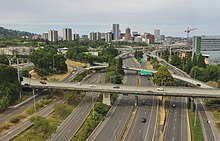
I-5 continues north from the Terwilliger curves through South Portland, running uphill from OR 43 on the western bank of the Willamette River and downhill from Barbur Boulevard (now carrying OR 10 and OR 99W). The freeway dives northeasterly towards the South Waterfront district to avoid Marquam Hill, home of the Oregon Health & Science University campus. The lanes of OR 43 are split between Hood and Macadam avenues on west and east sides of I-5 as it crosses under the Portland Aerial Tram and Gibbs Street Pedestrian Bridge.[28] The freeway passes under the Ross Island Bridge (part of US 26) and reaches the southern terminus of I-405, which it intersects in a large Y interchange situated over the light rail tracks of the MAX Orange Line and the Portland Streetcar.[15][29]

From the interchange, I-405 passes through the western part of Downtown Portland and Harbor Drive continues into downtown along the Willamette River waterfront.[5] I-5 continues northeast over the Willamette River on the double-decked Marquam Bridge, with its northbound lanes on the upper deck and southbound lanes carried on the lower deck. The bridge is the busiest crossing in Oregon, with over 140,000 daily vehicles traveling across it,[30] and runs parallel to the Tilikum Crossing transit bridge and Ross Island Bridge. The east end of the bridge, adjacent to the Oregon Museum of Science and Industry, has a southbound stub ramp that was built to serve the cancelled Mount Hood Freeway.[31][32] I-5 descends from the bridge and runs north along the Willamette River, following the eastern bank of the river and the Eastbank Esplanade bicycle and pedestrian trail a few blocks west of OR 99E. The freeway crosses over the east end of the Hawthorne Bridge and under the Morrison Bridge, intersecting the latter to provide direct access to Downtown Portland.[15]
After passing under the Burnside Bridge, I-5 intersects the western terminus of I-84, Oregon's lone east–west freeway and the main route through the Columbia River Gorge.[4][5] After the interchange, US 30 joins I-5 in a short concurrency while the freeway travels around major landmarks in the Rose Quarter, including the Oregon Convention Center, the Moda Center, and the Veterans Memorial Coliseum. At Northeast Holladay Street, the highway passes directly over the MAX Light Rail platforms of the Rose Quarter Transit Center just east of the Steel Bridge, which carries four MAX lines and OR 99W into Downtown Portland.[29][33] I-5 veers northwest and briefly into a sunken section near the Broadway Bridge, which carries the Portland Streetcar's loop lines.[29] Between the Boise and Eliot neighborhoods, the freeway intersects the terminating I-405 a short distance from the Fremont Bridge, which carries US 30 west into the Pearl District after it splits from I-5.[15] The interchange, located between the Legacy Emanuel Medical Center and Albina railyard,[34] has a set of three stub ramps that were built for the cancelled Rose City Freeway and were re-purposed to serve the hospital.[31]
Through most of North Portland, I-5 runs in a trench that is crossed by several local streets and pedestrian overpasses, connecting Interstate Avenue to the west and Albina Avenue to the east. Interstate Avenue, a part of OR 99W, also carries the MAX Yellow Line through the Overlook, Arbor Lodge, and Kenton neighborhoods.[35] At an interchange with Going Street, the freeway's northbound lanes gain the city's lone high-occupancy vehicle (HOV) lane, which runs for 3.5 miles (5.6 km) to the north end of Delta Park.[36] I-5 continues north and passes Peninsula Park and the Cascade campus of the Portland Community College in the Piedmont neighborhood before reaching an interchange with Lombard Street, which carries the US 30 Bypass. From the Lombard Street interchange, the freeway turns northwest and crosses over the Columbia Slough, reaching Delta Park on the site of the former city of Vanport.[37] The area also includes the Portland International Raceway and Portland Meadows horse racing track, along with several sports fields. At the north end of Delta Park, I-5 intersects the north end of OR 99E and the east end of OR 120, a short local route connecting to the Portland Expo Center (where the MAX Yellow Line terminates) and St. Johns.[5][35] The freeway continues north onto Hayden Island, where a single exit serves the entire island, and crosses over the Columbia River on the Interstate Bridge into Vancouver, Washington.[15] The Interstate Bridge carries a daily average of 132,000 vehicles and consists of two bridges that lift vertically for river traffic.[38]
History[]
I-5 roughly follows the Siskiyou Trail, an early trading route used by indigenous Oregonians and early trappers between the Willamette Valley and California.[39][40] The trail was re-purposed as a settler's route in 1846, following the creation of the Applegate Trail by the territorial government.[41] It was later incorporated into the early roads of the Willamette Valley, but remained secondary to waterborne transportation along the river and railroads built in the late 19th century.[42] The rising popularity of automobiles at the turn of the century spurred the construction of new highways and the formation of automobile clubs and good roads associations.[43]
The Pacific Highway Association was formed in 1910 to bolster an ongoing campaign to build a highway along the West Coast, from Tijuana to Vancouver, British Columbia.[44][45] The highway was incorporated into a state highway plan adopted by the Oregon State Highway Commission in 1914, a year after the state legislature had established the commission and a state highway department.[46] The first sections of the 345-mile (555 km) Pacific Highway were initially built by counties through bond issues and other revenue streams.[47] Jackson County was the first to begin construction on its section of the highway, breaking ground on a link between Siskiyou Summit and Medford on November 28, 1913.[48][49] These early sections were built using compacted dirt, which turned into mud in inclement weather and rendered them impassible. The state government enacted its own revenue sources for highway construction at the end of the decade, including the first state gas tax to be levied in the United States.[46] The Pacific Highway was completed in 1922 and was the first highway to be completely paved from border to border within a state west of the Mississippi River.[46]
The Oregon state legislature authorized the construction of controlled-access "throughways" (now called freeways) in 1947 and the Pacific Highway was designated as a future corridor the following year.[50][51] A six-cent gas tax increase was approved by the legislature in 1949 and would be used to improve sections of US 99 to freeway standards.[52] It would later be augmented by federal funding under the Interstate Highways program.[53]
Although not generally referred as such, the portion of I-5 south of Portland near Tigard to Salem was named the Robert Hugh Baldock Freeway after a former Oregon highway engineer.[54][55] Early proposals by engineers put the southern section of I-5 further east through Klamath Falls and the flatter Klamath Basin, but the Siskiyou Pass route was favored by local politicians.[56] Most of the highway in the Pacific Northwest was incorporated into U.S. Route 99 (US 99), created as part of a national highway system in 1926.[57] The Oregon section was divided between Junction City and Portland into US 99W and US 99E, with the latter taking the original route of the Pacific Highway.[58] It was completed on December 1, 1961, with direct connections to Harbor Drive in Downtown Portland.[59]
The first section of the East Bank Freeway in Portland, running 2.5 miles (4.0 km) from the Morrison Bridge to Shaver and Failing streets, opened to traffic on January 7, 1964.[60][61] The final section of Interstate 5 was dedicated on October 22, 1966, shortly after the completion of the Marquam Bridge.[62][63]
Exit list[]
| County | Location[64] | mi[64] | km | Exit | Destinations | Notes |
|---|---|---|---|---|---|---|
| Jackson | | 0.00 | 0.00 | — | Continuation into California | |
| | 0.74 | 1.19 | 1 | Siskiyou Summit | Northbound exit and southbound entrance; unsigned OR 273 | |
| | 4.30 | 6.92 | Siskiyou Summit, elevation 4,310 feet (1,310 m) | |||
| | 5.36 | 8.63 | 6 | Mount Ashland | Unsigned OR 273 | |
| | 11.62 | 18.70 | 11 | Northbound exit and southbound entrance | ||
| Ashland | 14.20 | 22.85 | 14 | |||
| | 19.14 | 30.80 | 19 | Valley View Road – Ashland | Valley View Road only appears on northbound signage | |
| Talent | 21.22 | 34.15 | 21 | Talent | ||
| Phoenix | 24.42 | 39.30 | 24 | Phoenix | ||
| Medford | 27.24 | 43.84 | 27 | |||
| 30.32 | 48.80 | 30 | Northbound exit and entrance | |||
| Southbound exit and entrance | ||||||
| Central Point | 32.78 | 52.75 | 33 | Central Point, Eagle Point | ||
| | 35.51 | 57.15 | 35 | |||
| | 40.86 | 65.76 | 40 | Northbound exit and entrance | ||
| Gold Hill | Southbound exit and entrance | |||||
| | 43.80 | 70.49 | 43 | OR 234, Gold Hill, and Crater Lake only appear on southbound signage | ||
| | 45.48 | 73.19 | 45A | |||
| | 45.75– 46.08 | 73.63– 74.16 | 45B | Valley of the Rogue State Park | ||
| Rogue River | 48.85 | 78.62 | 48 | City of Rogue River | ||
| Josephine | Grants Pass | 55.81 | 89.82 | 55 | ||
| 57.96– 58.34 | 93.28– 93.89 | 58 | South end of OR 99 concurrency | |||
| | 61.47 | 98.93 | 61 | Merlin | ||
| | 66.31 | 106.72 | 66 | Hugo | ||
| | 69.11 | 111.22 | Sexton Mountain Pass summit, elevation 1,960 feet (600 m) | |||
| | 71.42 | 114.94 | 71 | Sunny Valley | ||
| | 73.84 | 118.83 | Smith Hill summit, elevation 1,730 feet (530 m) | |||
| Wolf Creek | 75.82– 76.78 | 122.02– 123.57 | 76 | Wolf Creek | ||
| | 78.46 | 126.27 | 78 | Speaker Road | Southbound exit and northbound entrance | |
| | 79.81 | 128.44 | Stage Road Pass summit, elevation 1,830 feet (560 m) | |||
| Douglas | | 80.79 | 130.02 | 80 | Glendale | |
| | 83.28 | 134.03 | 83 | Barton Road | Northbound exit and southbound entrance | |
| 86.13 | 138.61 | 86 | Quines Creek Road / Barton Road | Barton Road only appears on southbound signage | ||
| | 88.12 | 141.82 | 88 | Azalea, Galesville Reservoir | ||
| | 90.19 | 145.15 | Canyon Creek Pass summit, elevation 2,020 feet (620 m) | |||
| | 95.81 | 154.19 | 95 | Canyon Creek | ||
| Canyonville | 98.27 | 158.15 | 98 | Canyonville, Days Creek | ||
| | 99.51 | 160.15 | 99 | North Canyonville, Stanton Park (northbound), Crater Lake (southbound) | ||
| | 101.05– 101.39 | 162.62– 163.17 | 101 | Riddle, Stanton Park | Stanton Park only appears on southbound signage | |
| | 101.89 | 163.98 | 102 | Gazley Road | ||
| Tri-City | 103.94 | 167.28 | 103 | Tri-City, Riddle | ||
| Myrtle Creek | 106.70 | 171.72 | 106 | Tri-City, Myrtle Creek | Northbound signage | |
| Weaver Road | Southbound signage | |||||
| 107.98– 108.47 | 173.78– 174.57 | 108 | Myrtle Creek | |||
| | 110.35 | 177.59 | 110 | Boomer Hill Road | ||
| | 112.12– 112.48 | 180.44– 181.02 | 112 | OR 99 and OR 42 only appear on northbound signage; Winston only appears on southbound signage; northern end of concurrency with OR 99 | ||
| | 113.43 | 182.55 | 113 | Clarks Branch Road – Round Prairie | ||
| | 116.42 | 187.36 | Roberts Mountain summit, elevation 956 feet (291 m) | |||
| Green | 119.50 | 192.32 | 119 | |||
| | 120.48 | 193.89 | 120 | Northbound exit only | ||
| Green District, Roseburg | Southbound exit and entrance | |||||
| | 121.68 | 195.82 | 121 | McLain Avenue | ||
| | 123.00 | 197.95 | 123 | Douglas County Fairgrounds, Umpqua Park | ||
| Roseburg | 124.13 | 199.77 | 124 | Southern end of concurrency with OR 138 | ||
| 125.07 | 201.28 | 125 | Garden Valley Boulevard – Roseburg | |||
| 126.51 | 203.60 | 127 | Edenbower Boulevard – North Roseburg | |||
| | 129.45 | 208.33 | 129 | Winchester | Northbound signage | |
| Wilbur | Southbound signage | |||||
| Sutherlin | 135.13 | 217.47 | 135 | Sutherlin, Wilbur | ||
| 136.51 | 219.69 | 136 | Northern end of concurrency with OR 138 | |||
| | 138.29 | 222.56 | 138 | Oakland | Northbound exit and southbound entrance | |
| | 140.53 | 226.16 | 140 | Southern end of concurrency with OR 99; southbound exit and northbound entrance | ||
| | 142.17 | 228.80 | 142 | |||
| | 142.31 | 229.03 | Rice Hill summit, elevation 723 feet (220 m) | |||
| | 146.24 | 235.35 | 146 | Rice Valley | ||
| Rice Hill | 148.40– 149.59 | 238.83– 240.74 | 148 | Rice Hill | ||
| | 150.32 | 241.92 | 150 | North end of OR 99 concurrenmcy | ||
| | 154.36– 154.95 | 248.42– 249.37 | 154 | , Elkhead | ||
| | 159.27 | 256.32 | 159 | Cox Road – Elk Creek | ||
| | 160.13 | 257.70 | 160 | Salt Springs Road | ||
| | 161.70 | 260.23 | 161 | Anlauf, Lorane | Northbound exit only | |
| | 162.35 | 261.28 | 162 | Southern end of concurrency with OR 99 | ||
| | 163.43 | 263.02 | 163 | Curtin, Lorane | ||
| Lane | | 168.36 | 270.95 | 170 | Northern end of concurrency with OR 99; northbound exit and southbound entrance | |
| | 172.23 | 277.18 | 172 | Sixth Street – Cottage Grove Lake | Southbound exit and northbound entrance | |
| Cottage Grove | 174.73 | 281.20 | 174 | Cottage Grove, Dorena Lake | ||
| | 176.75 | 284.45 | 176 | Saginaw | ||
| Creswell | 182.82 | 294.22 | 182 | OR 222 – Creswell | ||
| | 186.42 | 300.01 | 186 | Dillard Road – Goshen | Northbound exit only | |
| | 188.33 | 303.09 | 188A | Signed as Exit 188 southbound; OR 99 only appears on northbound signage; Klamath Falls only appears on southbound signage; southern end of concurrency with OR 99 | ||
| | 188.65 | 303.60 | 188B | |||
| | 189.64– 190.73 | 305.20– 306.95 | 189 | OR 225 / 30th Avenue – South Eugene | ||
| Springfield–Eugene line | 191.97 | 308.95 | 191 | OR 126 Bus. only appears on northbound signage | ||
| 192.26 | 309.41 | 192 | Northern end of concurrency with OR 99; northbound exit and southbound entrance | |||
| 192.74 | 310.18 | Whilamut Passage Bridge over the Willamette River | ||||
| 193.71– 194.18 | 311.75– 312.50 | 194A | ||||
| 194B | Exit 4 on I-105 | |||||
| 195.43– 195.70 | 314.51– 314.95 | 195A | Beltline Road east – Springfield, Gateway Mall | Signed as Exit 195 southbound; Beltline Road east only appears on northbound signage; Springfield and Eugene only appears on southbound signage | ||
| 195B | ||||||
| Coburg | 199.14 | 320.48 | 199 | Coburg National Historic District | ||
| Linn | | 209.05 | 336.43 | 209 | Harrisburg, Junction City | |
| | 216.56 | 348.52 | 216 | |||
| | 228.08 | 367.06 | 228 | |||
| Albany | 233.21 | 375.32 | 233 | Albany only appears on northbound signage; Sweet Home only appears on southbound signage | ||
| 233.85– 234.39 | 376.35– 377.21 | 234A | Knox Butte Road – /Expo Center | Signed as exit 234 northbound; no southbound entrance; southbound access via exit 233 | ||
| Albany–Millersburg line | 234B | Southern end of concurrency with OR 99E; southbound exit and northbound entrance | ||||
| Millersburg | 235.66 | 379.26 | 235 | Viewcrest | Northbound signage | |
| Millersburg | Southbound signage | |||||
| 237.66 | 382.48 | 237 | Viewcrest | No northbound exit | ||
| | 238.23 | 383.39 | 238 | OR 164 north – South Jefferson, Scio, Millersburg | South Jefferson only appears on northbound signage; Millersburg only appears on southbound signage | |
| | 239.66 | 385.70 | 239 | Dever–Conner | ||
| Linn–Marion county line | | 240.65 | 387.29 | Santiam River | ||
| Marion | | 242.12 | 389.65 | 242 | Talbot Road | |
| | 243.52 | 391.91 | 243 | Ankeny Hill | ||
| | 244.67 | 393.76 | 244 | OR 164 south – North Jefferson, Jefferson | North Jefferson only appears on northbound signage; Jefferson only appears on southbound signage | |
| | 248.40 | 399.76 | 248 | Delaney Road – , Turner | Sunnyside only appears on northbound signage; Delaney Road only appears on southbound signage | |
| Salem | 248.57 | 400.03 | 249 | Commercial Street | Northbound exit and southbound entrance | |
| 251.52 | 404.78 | 252 | Kuebler Boulevard | |||
| 253.86 | 408.55 | 253 | ||||
| 256.27 | 412.43 | 256 | Silverton only appears on northbound signage; Lancaster Mall only appears on southbound signage | |||
| 258.62 | 416.21 | 258 | Northbound signage; northern end of concurrency with OR 99E | |||
| North Salem, Oregon State Fairgrounds, L. B. Day Comcast Amphitheatre | Southbound signage | |||||
| 259.96 | 418.37 | 260A | Southbound exit and northbound entrance | |||
| 260.21 | 418.77 | 260B | Chemawa Road – Keizer | Signed as Exit 260 northbound; Chemawa Road only appears on northbound signage | ||
| | 263.48 | 424.03 | 263 | Brooks, Gervais | ||
| Woodburn | 271.85 | 437.50 | 271 | Molalla only appears on northbound signage; Silverton only appears on southbound signage | ||
| | 278.66 | 448.46 | 278 | Ehlen Road – Donald, Aurora National Historic District | Donald only appears on northbound signage; Ehlen Road only appears on southbound signage | |
| Clackamas | | 282.24 | 454.22 | 282A | Southbound exit and northbound entrance | |
| | 282.59 | 454.78 | 282 | Canby | Northbound signage | |
| 282B | Charbonneau District | Southbound signage | ||||
| Wilsonville | 283.10 | 455.61 | Boone Bridge over the Willamette River | |||
| 283.87 | 456.84 | 283 | Wilsonville Road | |||
| Washington | 286.17 | 460.55 | 286 | OR 141 north (Boones Ferry Road) / Elligsen Road | ||
| Tualatin | 288.20– 288.97 | 463.81– 465.05 | 288 | West Linn only appears on southbound signage | ||
| 289.49 | 465.89 | 289 | Nyberg Street / Tualatin-Sherwood Road - Tualatin | |||
| 290.47 | 467.47 | 290 | Lower Boones Ferry Road | |||
| Washington–Clackamas county line | Tigard | 291.29 | 468.79 | 291 | Carman Drive | |
| Tigard–Lake Oswego line | 292.19 | 470.23 | 292 | Signed as Exit 292 southbound; 72nd Avenue, Tigard, and Beaverton only appear on northbound signage; Lake Oswego only appears on southbound signage | ||
| 292 | Kruse Way, 72nd Avenue – Lake Oswego | |||||
| Washington | Tigard | 292.90– 293.28 | 471.38– 471.99 | 293 | Haines Street | |
| Multnomah | Portland | 293.79 | 472.81 | 294 | Barbur Boulevard | Northbound signage |
| Southbound signage | ||||||
| 295.03 | 474.80 | 295 | Capitol Highway | No northbound exit | ||
| 295.52 | 475.59 | 295 | Taylors Ferry Road | Northbound exit only | ||
| 296.30 | 476.85 | 296A | Barbur Boulevard | Southbound exit and northbound entrance | ||
| 296.68 | 477.46 | 296B | Multnomah Boulevard | Southbound exit and northbound entrance | ||
| 297.16 | 478.23 | 297 | Terwilliger Boulevard | No southbound entrance | ||
| 298.74 | 480.78 | 298 | Corbett Avenue | Northbound exit only | ||
| 299.16– 299.83 | 481.45– 482.53 | 299A | US 26 and Ross Island Bridge only appear on northbound signage; Lake Oswego only appears on southbound signage | |||
| 299.51– 300.27 | 482.01– 483.24 | 299B | No exit number southbound; City Center only appears northbound; Beaverton only appears southbound | |||
| 300.35– 300.45 | 483.37– 483.53 | Marquam Bridge over the Willamette River | ||||
| 300.65– 301.91 | 483.85– 485.88 | 300 | Northbound signage; access to OMSI and | |||
| 300B | Southbound signage; southbound exit and northbound entrance | |||||
| 301 | Southbound signage; southern end of concurrency with US 30 | |||||
| 302.08– 302.60 | 486.15– 486.99 | 302A | Broadway / Weidler Street – Moda Center | |||
| 302.73– 303.47 | 487.20– 488.39 | 302B | Beaverton only appears on southbound signage; northern end of concurrency with US 30 | |||
| 303.15 | 487.87 | 302C | Greeley Avenue – Swan Island | Northbound exit and southbound entrance | ||
| 303.75– 304.47 | 488.84– 490.00 | 303 | Killingsworth Street – Swan Island | Northbound signage | ||
| Alberta Street – Swan Island | Southbound signage | |||||
| 304.92 | 490.72 | 304 | Rosa Parks Way | |||
| 305.43 | 491.54 | 305 | Northbound exit and southbound entrance; signed as Exits 305A (east) and 305B (west) | |||
| 305.91 | 492.31 | 306A | Columbia Boulevard | Northbound exit and southbound entrance | ||
| 306.44 | 493.17 | 306B | Victory Boulevard – Expo Center | No southbound exit | ||
| 306.97 | 494.02 | 306 | Southbound exit and northbound entrance; former OR 99W south | |||
| 307.33 | 494.60 | 307 | Delta Park only appears on northbound signage | |||
| North Portland Harbor | 307.45– 307.70 | 494.79– 495.20 | ||||
| Hayden Island | 307.77– 307.99 | 495.31– 495.66 | 308 | Hayden Island, ODOT Permits | ||
| Columbia River | 308.17– 308.37 | 495.95– 496.27 | Interstate Bridge | |||
| Continuation into Washington | ||||||
1.000 mi = 1.609 km; 1.000 km = 0.621 mi
| ||||||
References[]
- ^ "Table 1: Main Routes of the Dwight D. Eisenhower National System Of Interstate and Defense Highways as of December 31, 2017". Federal Highway Administration. December 31, 2017. Retrieved June 22, 2018.
- ^ Official Route Numbering for the National System of Interstate and Defense Highways (Map). American Association of State Highway Officials, Public Roads Administration. August 14, 1957. Retrieved April 14, 2013.
- ^ Weingroff, Richard F. (Summer 1996). "Federal-Aid Highway Act of 1956, Creating the Interstate System". Public Roads. Washington, D.C.: Federal Highway Administration. 60 (1). ISSN 0033-3735. Retrieved April 14, 2013.
- ^ a b Kramer, George (May 2004). The Interstate Highway System in Oregon: A Historic Overview (PDF) (Report). Oregon Department of Transportation. p. 1. Retrieved June 24, 2018 – via Oregon State Library.
- ^ a b c d e f g h i j k l m n Oregon 2017–2019 Official State Map (PDF) (Map). Oregon Department of Transportation. March 2017. Retrieved June 24, 2018, with inset maps.
- ^ Transportation Development Division (April 2001). Study of Eastern Oregon Freeway Alternatives, Pursuant to House Bill 3090 (PDF) (Report). Oregon Department of Transportation. p. 12. Retrieved September 4, 2018.
- ^ "Functional Classification". Oregon Department of Transportation. Retrieved June 24, 2018.
- ^ National Highway System: Oregon (PDF) (Map). Federal Highway Administration. March 25, 2015. Retrieved June 24, 2018.
- ^ a b ODOT Transportation Data Section and Transportation Systems Monitoring Unit (November 2018). "2017 Transportation Volume Tables" (PDF). Oregon Department of Transportation. pp. 17–21, 31–33. Retrieved December 3, 2018.
- ^ Bengel, Erick (January 11, 2016). "Highway becomes a memorial to veterans of recent wars". Daily Astorian. Retrieved September 9, 2018.
- ^ Miller, Mark (January 13, 2016). "Purple Heart Trail signage placed along Interstate 5 in Tualatin". Beaverton Valley Times. Pamplin Media Group. Retrieved October 1, 2018.
- ^ "Respect the Siskiyou Pass" (PDF). Oregon Department of Transportation. September 2005. Retrieved June 22, 2018.
- ^ a b Fattig, Paul (October 30, 2012). "ODOT plans to use rock salt for I-5 ice melt". Mail Tribune. Medford, Oregon. Archived from the original on August 10, 2020. Retrieved June 22, 2018.
- ^ Rose, Joseph (March 22, 2013). "How a wrong-way big rig delivered frozen freeways in Portland". The Oregonian. Retrieved June 22, 2018.
- ^ a b c d e f g h i j k l m Google (June 22, 2018). "Interstate 5, Oregon" (Map). Google Maps. Google. Retrieved June 22, 2018.
- ^ Richard, Terry (August 30, 2015). "The softer, gentler approach to Pacific Crest Trail". The Oregonian. p. R4. Retrieved June 22, 2018.
- ^ Nguyen, Tran (March 1, 2018). "Rest for the weary". Mail Tribune. Medford, Oregon. Archived from the original on July 10, 2018. Retrieved July 9, 2018.
- ^ Kramer, George. "Medford". The Oregon Encyclopedia. Retrieved June 23, 2018.
- ^ a b c d e f Hale, Jamie; Eastman, Janet (June 24, 2018). "The best I-5 pit stops in Oregon". The Oregonian. Retrieved September 9, 2018.
- ^ "50th Anniversary of the Interstate Highway System: Interstate 5 (Pacific Highway)". Oregon Department of Transportation. Archived from the original on December 4, 2006. Retrieved June 23, 2018.
- ^ Mann, Damian (January 29, 2016). "Could the I-5 viaduct be replaced?". Mail Tribune. Medford, Oregon. Archived from the original on June 24, 2018. Retrieved June 23, 2018.
- ^ Gottberg Anderson, John (February 6, 2011). "Giant redwoods date back thousands of years". Bend Bulletin. Retrieved September 9, 2018.
- ^ "4 NW projects win AGC 'Oscars'". Seattle Daily Journal of Commerce. March 27, 2015. Retrieved July 9, 2018.
- ^ Heinz, Spencer (September 13, 1992). "A parallel to live by". The Oregonian. p. C2.
- ^ Kulla, Josh (September 18, 2013). "Letting history remain in the past". Wilsonville Spokesman. Pamplin Media Group. Retrieved July 9, 2018.
- ^ Williams, Christina (August 23, 2012). "Oregon's solar highway project open to visitors". Portland Business Journal. Retrieved July 9, 2018.
- ^ Grace Lednicer, Lisa (February 20, 2005). "The kink in Portland's bottleneck". The Oregonian. p. A1.
- ^ Koffman, Rebecca (July 12, 2012). "New pedestrian and bicycle bridge across Interstate 5 opens Saturday in Southwest Portland". The Oregonian. Retrieved July 10, 2018.
- ^ a b c Portland City Center (PDF) (Map). TriMet. Retrieved July 10, 2018.
- ^ Boddie, Ken (January 16, 2018). "Where We Live: How the Marquam Bridge got its name". KOIN. Retrieved July 10, 2018.
- ^ a b Anderson, Jennifer (April 19, 2007). "Stumptown Stumper". Portland Tribune. Pamplin Media Group. Retrieved July 9, 2018.
- ^ Mayer, James (July 3, 1989). "Running ramp-ant: Final chapter to lose on 'stubs' at east end of Marquam Bridge". The Oregonian. p. B3.
- ^ Kelsey, Doug (January 29, 2016). "Here's How We Plan to Improve MAX Reliability". TriMet. Retrieved July 10, 2018.
- ^ Marum, Anna (January 23, 2018). "N. Portland oil spill reaches Willamette". The Oregonian. Retrieved July 9, 2018.
- ^ a b "MAX Yellow Line Fact Sheet" (PDF). TriMet. July 2016. Retrieved July 10, 2018.
- ^ Rose, Joseph (September 5, 2012). "Commuting: More thoughts on Portland's lone HOV lane ('spineless' and otherwise)". The Oregonian. Retrieved July 9, 2018.
- ^ Hewitt, Scott (September 16, 2016). "The city that submerged". The Columbian. Retrieved July 10, 2018.
- ^ Solomon, Molly (March 22, 2017). "Rising Columbia River Means More Bridge Lifts For Commuters". Oregon Public Broadcasting. Retrieved July 10, 2018.
- ^ Fiorini, Gail (December 27, 2017). "As It Was: Modern highway follows the historic Siskiyou Trail". Ashland Daily Tidings. p. A4. Retrieved June 23, 2018.
- ^ Bjornstad, Randi (January 4, 2015). "It's been a long road". The Register-Guard. Eugene, Oregon. Retrieved June 23, 2018.
- ^ LaLande, Jeff. "Applegate Trail". The Oregon Encyclopedia. Retrieved July 13, 2018.
- ^ McCarthy, Linda (April 1, 1999). "Exhibit retraces highway of yesteryear". The Oregonian. p. 10.
- ^ Hoyt, Jr., Hugh Myron (June 1966). The Good Roads Movement in Oregon: 1900–1920 (PhD). University of Oregon. p. 70. CiteSeerX 10.1.1.876.5064.
- ^ "Pacific Highway Campaign Plans Now Completed". Oregon Daily Journal. April 30, 1911. p. 26. Retrieved August 11, 2018 – via Newspapers.com.

- ^ "Great Highway is Planned From North to South". The Eugene Guard. November 16, 1910. p. 6. Retrieved August 11, 2018 – via Newspapers.com.
- ^ a b c "The First 75 Years". Oregon Department of Transportation. 1988. pp. A4, A6. Retrieved August 11, 2018 – via Oregon State Library.
- ^ Livingston, Jill (2003). That Ribbon of Highway III: Highway 99 Through the Pacific Northwest. Klamath River, California: Living Gold Press. pp. 4–8. ISBN 0-9651377-6-7. OCLC 51855448.
- ^ "Sam Hill Starts Road". Morning Register. Eugene, Oregon. November 29, 1913. p. 1. Retrieved August 11, 2018 – via Newspapers.com.
- ^ Aldous, Vickie (April 16, 2015). "Tales of Highway 99". Medford Mail Tribune. Retrieved August 11, 2018.
- ^ Harvey Jr., Paul W. (March 22, 1947). "Throughways Bill Now Law". Capital Journal. p. 1. Retrieved September 9, 2018 – via Newspapers.com.
- ^ "'Throughways' Status is Given Most Highways". The News-Review. Roseburg, Oregon. Associated Press. November 5, 1948. p. 9. Retrieved September 9, 2018 – via Newspapers.com.
- ^ Harvey Jr., Paul W. (April 5, 1949). "Gasoline Taxes, Motor License Fees Increased". Capital Journal. p. 1. Retrieved September 9, 2018 – via Newspapers.com.
- ^ Kramer, George. "Interstate 5 in Oregon". The Oregon Encyclopedia. Retrieved June 22, 2018.
- ^ Oregon_Interstate_Highway_Overview_2004.pdf
- ^ "RHSamBaldock.pdf" (PDF). oregon.gov.
- ^ Liedtke, Kurt (March 5, 2017). "150 years beside the river: Sesquicentennial celebration to recount Linkville's past". Herald and News. Klamath Falls, Oregon. p. A1. Retrieved June 23, 2018.
- ^ Bureau of Public Roads; American Association of State Highway Officials (November 11, 1926). United States System of Highways Adopted for Uniform Marking by the American Association of State Highway Officials (Map). 1:7,000,000. Washington, DC: U.S. Geological Survey. OCLC 32889555. Retrieved August 11, 2018 – via Wikimedia Commons.
- ^ "Highway Signs To Be Reality". Corvallis Gazette-Times. May 23, 1930. p. 1. Retrieved August 11, 2018 – via Newspapers.com.
- ^ Edwards, Herman (October 20, 1963). "Section Of East Bank Freeway To Open Within Weeks". The Oregonian. p. 36.
- ^ Edwards, Herman (January 8, 1964). "Traffic Speeds Over First Section Of East Bank Freeway". The Oregonian. p. 11.
- ^ "East bank Freeway To Require Changes In Driving Habits". The Oregonian. December 25, 1963. p. 37.
- ^ Harvey, Paul W. (October 22, 1966). "Hatfield Keeps Promise; Dedicates Completed Freeway". Corvallis Gazette-Times. p. 5. Retrieved June 22, 2018 – via Newspapers.com.
- ^ "I-5 now completed throughout Oregon". The Oregon Motorist. . 46 (2). February 1967. Retrieved April 14, 2013.
- ^ a b Road Inventory and Classification Services Unit. "Straightline Charts". Transportation Development Division, Oregon Department of Transportation. Retrieved September 24, 2016.
- Pacific Highway No. 1 (October 2013)
External links[]
Route map:
| ( • help)
|
 Media related to Interstate 5 in Oregon at Wikimedia Commons
- Interstate Highways in Oregon
- Interstate 5
- U.S. Route 99
- Willamette Valley
- Transportation in Washington County, Oregon
- Transportation in Marion County, Oregon
- Transportation in Josephine County, Oregon
- Transportation in Clackamas County, Oregon
- Transportation in Lane County, Oregon
- Transportation in Jackson County, Oregon
- Transportation in Multnomah County, Oregon
- Transportation in Linn County, Oregon
- Transportation in Douglas County, Oregon