Interstate 678
 | ||||
|---|---|---|---|---|
 Map of the New York City area with I-678 highlighted in red | ||||
| Route information | ||||
| Auxiliary route of I-78 | ||||
| Maintained by NYSDOT, MTAB&T, and PANYNJ | ||||
| Length | 14.33 mi[1] (23.06 km) | |||
| Existed | c. 1965[2][3]–present | |||
| Major junctions | ||||
| South end | ||||
| North end | ||||
| Location | ||||
| Counties | Queens, Bronx | |||
| Highway system | ||||
| ||||
Interstate 678 (I-678) is a north–south auxiliary Interstate Highway that extends for 14 miles (23 km) through two boroughs of New York City. The route begins at John F. Kennedy International Airport on Jamaica Bay and travels north through Queens and across the East River to the Bruckner Interchange in the Bronx, where I-678 ends and the Hutchinson River Parkway begins.
I-678 connects to I-495 (the Long Island Expressway) in Flushing Meadows–Corona Park. The highway is known as the Van Wyck Expressway (/væn ˈwɪk/ van WIK or /væn ˈwaɪk/ van WYKE)[4] from JFK Airport to Northern Boulevard (New York State Route 25A or NY 25A), the Whitestone Expressway from NY 25A north to the Bronx–Whitestone Bridge, and the Hutchinson River Expressway from the bridge to the Bruckner Interchange. North of the interchange, I-678 ends and the roadway continues as the Hutchinson River Parkway.
The portion of I-678 north of NY 25A follows the path of the Whitestone Parkway and a short section of the Hutchinson River Parkway's Bronx extension. The Whitestone Parkway and Hutchinson River Parkway was first opened in 1939, while the Van Wyck Expressway opened in pieces between 1950 and 1953. Both highways were connected to each other and upgraded to meet Interstate Highway standards in the early 1960s. The Hutchinson River and Whitestone Expressways were collectively designated as I-678 c. 1965. The designation was extended southward in 1970 to follow the Van Wyck Expressway to its end at JFK Airport.[5]
Route description[]
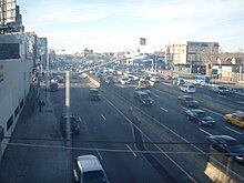
I-678 begins at John F. Kennedy International Airport in the borough of Queens and proceeds along the stretch of highway known as the Van Wyck Expressway. I-678 progresses westward through the airport, crossing under airport taxiways as a six-lane freeway. Just after the taxiways, the expressway connects with North Service Road, which services the airport's western services. From there, the expressway begins to turn northward and crosses the United Airlines hangar. I-678 continues its northwestern path, curving to the northeast at the interchange with Federal Circle. From there, the highway continues northward, becoming a divided highway and meeting NY 878 (the Nassau Expressway) at exit 1E. I-678 continues northward, crossing under the Nassau Expressway and over NY 27 east (South Conduit Avenue) and the Belt Parkway. A short distance later, the highway intersects NY 27 west (North Conduit Avenue) at exit 1B.[6][7]
North of North Conduit Avenue, AirTrain JFK's elevated people mover structure begins to run above the expressway's median, and the Van Wyck descends to an open-cut structure.[8] At this point, I-678 gains service roads on either side, connecting to local streets. I-678 continues northward along the Van Wyck Expressway through Queens, interchanging with Rockaway Boulevard, Linden Boulevard, Liberty Avenue, and Atlantic Avenue at exits 2 through 5, respectively. Just south of Atlantic Avenue, the AirTrain structure diverges to the east.[8] After entering Jamaica, the Van Wyck crosses under a complex, two-level Long Island Rail Road structure with thirteen tracks.[6][7]
Continuing northward, the expressway passes the Jamaica Hospital and intersects Jamaica Avenue at exit 6. I-678 expands to eight lanes as it crosses under Hillside Avenue (NY 25B), which is serviced by exit 7 in the southbound direction. A short distance later, the highway approaches a large interchange with NY 25 (Queens Boulevard) and Main Street at exits 8–9. After crossing under Hoover Avenue, I-678 enters the Kew Gardens Interchange, a complex interchange with traffic from five directions. I-678 crosses on overpasses over Union Turnpike, the Grand Central Parkway, the Jackie Robinson Parkway, and different interchange ramps before returning at-grade in Flushing. There, the highway turns northwestward once again, interchanging with Jewel Avenue via Park Drive East at exit 11. Crossing through Flushing Meadows Corona Park, I-678 continues northward until exit 12, where there are ramps to College Point Boulevard and the westbound Long Island Expressway (I-495). After the interchange with the Long Island Expressway, the Van Wyck continues northeastward. A short distance later, the expressway crosses under Roosevelt Avenue and the IRT Flushing Line (7 and <7> trains) of New York City Subway. After crossing Roosevelt Avenue, I-678 passes Citi Field to the west, then intersects NY 25A (Northern Boulevard) via exit 13. At this point, I-678 transitions onto Whitestone Expressway.[6][7]
The Whitestone Expressway continues northward into College Point, where the service roads resume. I-678 passes over Linden Place, served by exit 14, and continues northeastward past the distribution center of The New York Times to the west. Shortly afterward, I-678's service roads intersect with 20th Avenue in Whitestone, and there are ramps to and from the service roads at exit 15. I-678 passes under 14th Avenue a short distance to the north. Just after 14th Avenue, the left-hand lanes of both directions diverge to exit 16, which continues onto Cross Island Parkway via a left exit. The service roads end at this point.[6][7]
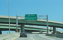
After the interchange with Cross Island Parkway, the Whitestone Expressway turns to the northwest as a six-lane expressway that passes through Whitestone. After Exit 17, which serves Third Avenue, the expressway passes over Francis Lewis Park and begins its approach onto the Bronx–Whitestone Bridge over the East River. The highway leaves Queens and enters the Bronx along the bridge.[6][7] The bridge descends to ground level and I-678 passes through an open-road toll gantry,[7] which is located at the former site of a tollbooth.[9] Afterwards, the expressway intersects Lafayette Avenue. North of Lafayette Avenue is the Bruckner Interchange, where I-678's designation ends and the highway continues northward as the Hutchinson River Parkway.[6][7]
History[]
Whitestone Expressway[]
In 1936, Governor Herbert H. Lehman signed a bill that authorized the construction of the Bronx–Whitestone Bridge, which would connect Queens and the Bronx.[10] At its north end, the Bronx–Whitestone Bridge would connect to Eastern Boulevard (later known as Bruckner Boulevard) via the Hutchinson River Parkway.[11] At its south end, the bridge would connect to a new Whitestone Parkway, which led southwest off the bridge to Northern Boulevard.[11][12] Plans for the bridge were completed by February 1937, at which time the state started issuing bonds to fund bridge construction.[13] The right-of-way for the Whitestone Bridge and Parkway was legally designated in July 1937.[14]
The Whitestone Bridge and Parkway both opened on April 29, 1939.[15] Construction on the bridge and parkway had been accelerated in preparation for the 1939 New York World's Fair,[15] which opened one day after the Whitestone Bridge and Parkway. The new highway was intended as a major thoroughfare to the World's Fair, which was hosted in Flushing Meadows–Corona Park, near the Whitestone Parkway's southern end.[16]

In December 1957, the state approved a $9.5 million project to widen a 2.1-mile (3.4 km) segment of Whitestone Parkway from Northern Boulevard to the Bronx-Whitestone Bridge, build a new bridge over the Flushing River, and improve the parkway to Interstate Highway standards using funds from the Federal-Aid Highway Act of 1952, in which the federal government would pay 90% of the proposed highway's cost. At the time, the parkway hosted two lanes in each direction, and the design process for such an upgrade was nearing completion.[17] The head of the Triborough Bridge and Tunnel Authority, Robert Moses, stated that the upgrade could start in 1960. At the time of the announcement, the junction with Northern Boulevard was heavily congested because motorists used local streets to connect to the Grand Central Parkway, located opposite Flushing Meadows Park from the Whitestone Parkway.[18] Flushing Meadows Park was subsequently selected to host the 1964 New York World's Fair. In early 1960, the state announced that work on the project would start that year.[19] The project would be one of three highway upgrades for the World's Fair.[20] The city approved the $10 million upgrade project in May 1960,[21] and contracts for the upgrade were awarded in September 1962.[22] The portion of the Hutchinson River Parkway south of Bruckner Boulevard and all of the Whitestone Parkway were converted to interstate standards. The Whitestone Parkway was subsequently renamed the Whitestone Expressway, and the aforementioned segment of the Hutchinson River Parkway was renamed the Hutchinson River Expressway.[23][24]
Van Wyck Expressway[]
In the 1940s, Moses proposed the construction of a system of highways that would traverse the New York City area.[25] The plan was to cost $800 million, and in 1945, the city agreed to pay $60 million of that cost.[26] Among them was the Van Wyck Expressway, which would stretch from New York (now John F. Kennedy) International Airport in the south to Queens Boulevard in the north.[25] The six-lane expressway was to be built along the path of what was then Van Wyck Boulevard.[27] The original street and the freeway were both named after former New York City Mayor Robert Anderson Van Wyck, but the pronunciation of "Wyck" was heavily disputed: depending on the person, "Wyck" could rhyme with either "lick" or "like".[4]
In 1946, the city started evicting or relocating people who lived in the proposed expressway's right-of-way.[28] Ultimately, 263 households had to be relocated.[29] One 4-story apartment building, which housed 35 families, was placed on metal rollers and relocated away from the expressway's path. Normally, new houses would have been built for these families, but in this case, there was not enough land area to build individual homes for these families.[30]
The section of Van Wyck Expressway between Queens Boulevard and the airport opened in October 1950.[31] A northern extension to Grand Central Parkway was opened in 1953. This section of the expressway originally functioned as a connector between Grand Central and the airport.[32] In mid-1961, it was revealed that the Van Wyck Expressway would be extended northward to meet the Whitestone Expressway at NY 25A for the 1964 World's Fair.[20] Work on the Van Wyck Expressway Extension, as it was originally known, began in December 1961[33] and was completed by 1963.[24] The I-678 designation was extended southward over the Van Wyck Expressway to JFK Airport on January 1, 1970.[5]
Combined highway[]
The Whitestone and Hutchinson River Expressways were designated as I-678 c. 1965.[2][3] While designated as a three-digit auxiliary Interstate Highway, I-678 never intersects with its ostensible "parent" interstate, I-78. Originally, I-78 would have continued eastward through New York City from its current terminus at the Holland Tunnel along the proposed Lower Manhattan Expressway and over the Williamsburg Bridge to Queens, where it would have followed the Bushwick Expressway past the southern end of the Van Wyck Expressway to Laurelton. From here, I-78 would have continued northward onto an extended Clearview Expressway and to the Bronx.[34][35] Early plans for I-678 had the highway following the Astoria Expressway, a proposed freeway that would run along the NY 25A corridor from I-278 to the Grand Central Parkway.[34] These plans were mostly canceled by the late 1960s,[36] leading to the truncation of I-78 to the Brooklyn–Queens Expressway (I-278) on January 1, 1970.[5] In March 1971, Governor Nelson Rockefeller revealed a plan for improving New York City highways. The plan denied funding to several proposed New York City Interstate Highways, including the Astoria Expressway. Rockefeller said that these highways did not qualify for a funding agreement from the Federal-Aid Highway Act of 1952. The New York Times quoted a state official who said that this move had the effect of canceling these projects.[37] I-78 currently ends at the east portal of the Holland Tunnel.[38][39]
In early 1988, both directions of the Whitestone Expressway near Northern Boulevard were temporarily closed because several girders in the southbound viaduct had corroded to the point that a structural failure was imminent.[40] This part of the Whitestone Expressway, as well as the Van Wyck Expressway from Fowler Avenue south to the Long Island Expressway, were renovated in the mid-1990s.[41] Starting in 2003, the northbound lanes of the Whitestone Expressway near Northern Boulevard were renovated. The project involved replacing a bascule bridge that had been at the location since the original parkway had opened in 1939; creating two U-turn ramps; and creating a new exit ramp from eastbound Northern Boulevard to Linden Place. Previously, traffic from Northern Boulevard had to cross over three lanes of northbound traffic from the Van Wyck Expressway.[42][43]

The Jamaica Branch of the AirTrain JFK people mover system was built within the median of the Van Wyck from Atlantic Avenue to the Belt Parkway. Construction started in May 1998.[44][45]: 22 The fact that the Jamaica branch had to be built in the middle of the Van Wyck Expressway, combined with the varying length and curves of the track spans, caused complications during construction. One lane in each direction was closed during the off-peak hours, causing congestion on the Van Wyck.[45]: 22 The AirTrain's guideways above the Van Wyck were completed in August 2001.[46] The system opened in December 2003.[47]
Further to the north, a $286 million renovation of the Bronx-Whitestone Bridge started in August 2001.[48][49] The project replaced the bridge's span, among other things.[50] The Queens and Bronx approaches were replaced in a project that started in 2008[51] and ended in 2015.[52]
In early 2017, Governor Andrew Cuomo announced that as part of his plan to improve JFK Airport, two traffic bottlenecks along I-678 near the airport would be removed. At the Kew Gardens Interchange, the two-lane ramps between the Grand Central Parkway and the Van Wyck Expressway would be upgraded to three lanes in each direction. South of the interchange, the expressway will be expanded from three lanes to four lanes in each direction, with the new lanes being used as either HOV lanes or bus lanes. These projects, combined, would cost $1.5–2 billion.[53][54] In October 2018, Cuomo released details of his $13 billion plan to rebuild passenger facilities and approaches to JFK Airport. The plan included widened ramps in Kew Gardens and a fourth vehicle lane on the Van Wyck Expressway south of Kew Gardens.[55][56] In addition, northbound exit 5 at Atlantic Avenue and southbound exit 4 at Liberty Avenue would be permanently closed, as these junctions are near each other.[57] If the proposal is approved, construction is expected to begin in spring 2020[58][59] and would be completed three years later.[57]
Exit list[]
| Borough | Location | mi[60] | km | Exit | Destinations | Notes |
|---|---|---|---|---|---|---|
| Queens | JFK Airport | 0.00 | 0.00 | – | Southern terminus | |
| 0.30 | 0.48 | A | ||||
| 1.10 | 1.77 | B | Southbound exit only | |||
| 1.40 | 2.25 | C | ||||
| South Ozone Park | 1.70– 2.50 | 2.74– 4.02 | 1 | Exit 1 on NY 878 | ||
| Signed as exits 1E (east) and 1W (west); exit 19 on Belt Parkway | ||||||
| 2.66 | 4.28 | 2 | Rockaway Boulevard | Signed with exit 1 northbound | ||
| 3.20 | 5.15 | 3 | Linden Boulevard | |||
| 3.90 | 6.28 | 4 | Liberty Avenue | |||
| Richmond Hill | 4.37 | 7.03 | 5 | Atlantic Avenue | No southbound exit | |
| 4.76 | 7.66 | 6 | Jamaica Avenue / Hillside Avenue | |||
| Kew Gardens | 5.00 | 8.05 | 8 | Main Street / Union Turnpike | No southbound exit to eastbound Union Turnpike; signed as exit 7B southbound | |
| 5.34 | 8.59 | 9 | No northbound entrance; signed as exit 7C southbound | |||
| 5.87 | 9.45 | 10 | Northbound exit and southbound entrance; exit 13S on G. C. Parkway; no commercial vehicles | |||
| 5.90 | 9.50 | 7A | Southbound exit and northbound entrance; exit 7 on J. Robinson Parkway; no commercial vehicles | |||
| Flushing Meadows–Corona Park | 6.20– 6.90 | 9.98– 11.10 | 11 | 69th Road / Jewel Avenue – Flushing Meadows–Corona Park | ||
| 7.20– 8.30 | 11.59– 13.36 | 12 | Signed as exits 12A (east) and 12B (west); exits 22C–D on I-495 eastbound only; exit 22B on I-495 westbound only | |||
| Willets Point | 8.90– 9.43 | 14.32– 15.18 | 13 | Signed southbound as exit 13A (Astoria Boulevard), 13B (Parkway east), 13C (Parkway west), and 13D (NY 25A west); no southbound access to NY 25A east | ||
| Flushing Creek | Bridge (northern terminus of Van Wyck Expressway, southern terminus of Whitestone Expressway) | |||||
| Flushing | 9.90 | 15.93 | 14 | Linden Place | ||
| 10.80 | 17.38 | 15 | 14th Avenue / 20th Avenue | |||
| Whitestone | 11.30 | 18.19 | 16 | Northern terminus and exit 36 on Cross Island Parkway; no commercial vehicles | ||
| 11.60 | 18.67 | 17 | 3rd Avenue | No southbound exit | ||
| East River | 11.90– 12.50 | 19.15– 20.12 | Bronx–Whitestone Bridge (toll) | |||
| The Bronx | Throggs Neck | 13.60 | 21.89 | 18 | Lafayette Avenue – Ferry Point Park | |
| 13.90– 14.33 | 22.37– 23.06 | 19N | Northbound exit and southbound entrance; exit 6A on I-95 | |||
| 19S-W | Northbound exit and southbound entrance; other movements via Hutchinson Parkway exit 1; eastern terminus of I-278 | |||||
| – | Continuation beyond Bruckner Interchange; no commercial vehicles | |||||
1.000 mi = 1.609 km; 1.000 km = 0.621 mi
| ||||||
See also[]
References[]
- ^ New York State Department of Transportation (June 16, 2009). 2008 Traffic Volume Report for New York State (PDF) (Report). Albany: New York State Department of Transportation. pp. 242–243. Archived from the original (PDF) on September 27, 2012. Retrieved July 13, 2010.
- ^ a b Sinclair Oil Corporation; Rand McNally and Company (1964). New York and Metropolitan New York (Map). 1:757,000. Chicago: Sinclair Oil Corporation. Lower New York and Long Island inset.
- ^ a b Gulf Oil Corporation; Rand McNally and Company (1965). Metropolitan New York City Area, Tourgide [sic] map (Map). 1:364,152. Pittsburgh, PA: Gulf Oil Corporation. Metropolitan New York City area, including Westchester County, N.Y., and northeastern New Jersey inset. OCLC 246639605.
- ^ a b Bilefsky, Dan (May 26, 2011). "Stuck on the Van Wyck Expressway? Just Try to Pronounce It". The New York Times. p. A28. Retrieved June 20, 2012.
- ^ a b c State of New York Department of Transportation (January 1, 1970). Official Description of Touring Routes in New York State (PDF). Albany: State of New York Department of Transportation. Retrieved July 14, 2010.
- ^ a b c d e f Microsoft; Nokia (July 14, 2010). "Overview Map of Interstate 678" (Map). Bing Maps. Microsoft. Retrieved July 14, 2010.
- ^ a b c d e f g Google (January 6, 2017). "Overview Map of I-678" (Map). Google Maps. Google. Retrieved January 6, 2017.
- ^ a b Federal Aviation Administration; New York State Department of Transportation (1997). JFK International Airport Light Rail System: Environmental Impact Statement. Vol. 1. Washington, DC: Federal Aviation Administration. p. 1.12. Retrieved August 26, 2017 – via Google Books.
|volume=has extra text (help) - ^ Castillo, Alfonso A. (October 2, 2017). "Cashless Tolling Arrives at All MTA Bridges". Newsday. Retrieved February 16, 2018.
- ^ "Lehman Signs Bill for Relief Bonds" (PDF). The New York Times. May 21, 1936. ISSN 0362-4331. Retrieved December 19, 2017.
- ^ a b Esso; General Drafting (1940). New York (Map). 1:687,000. New York: Esso. New York City inset.
- ^ Esso; General Drafting (1942). New York with Pictorial Guide (Map). 1:687,000. New York: Esso. New York City inset.
- ^ "Whitestone Bridge at Financing Stage: Authority Scans Two Plans for a Bond Issue to Build Bronx-Queens Span" (PDF). The New York Times. February 15, 1937. ISSN 0362-4331. Retrieved December 19, 2017.
- ^ "City Gets Queens Land: 2 1/2-Mile Strip Being Taken for Link to Whitestone Bridge" (PDF). The New York Times. July 22, 1937. ISSN 0362-4331. Retrieved December 19, 2017.
- ^ a b "Whitestone Span to Open Saturday". The New York Times. April 27, 1939. p. 23. Retrieved April 4, 2010.
- ^ "1,000,000 to See Fair Opening" (PDF). The New York Times. April 30, 1939. ISSN 0362-4331. Retrieved December 19, 2017.
- ^ "9.5 Million Project to Aid Boro Traffic" (PDF). Long Island Star-Journal. December 16, 1957. p. 1 – via Fultonhistory.com.
- ^ "Parkway Link to End Northern Blvd. Jams" (PDF). Long Island Star-Journal. January 9, 1958. p. 1 – via Fultonhistory.com.
- ^ "State Road Work Rises 360 Million" (PDF). The New York Times. April 8, 1960. Retrieved January 14, 2018.
- ^ a b "Highway Work Set on 3 New Projects" (PDF). Long Island Star-Journal. December 7, 1961. p. 2 – via Fultonhistory.com.
- ^ "25 Million in Roads Approved for City" (PDF). The New York Times. May 19, 1960. Retrieved January 14, 2018.
- ^ "Whitestone X-Way, New Flushing Span OK" (PDF). Long Island Star-Journal. September 28, 1962. p. 3 – via Fultonhistory.com.
- ^ Rand McNally and Company (1962). Long Island and New York City (Map). 1:82,902. Chicago: Rand McNally and Company. Long Island (Western Section) inset. OCLC 55707497.
- ^ a b Esso; General Drafting (1963). New York Happy Motoring Guide (Map) (1963 ed.). 1:687,000. Convent Station, NJ: Esso. Northern approaches to New York City inset. OCLC 26606599.
- ^ a b Moscow, Warren (March 13, 1944). "Highway Network Proposed for City Hits Albany Snag" (PDF). The New York Times. ISSN 0362-4331. Retrieved December 19, 2017.
- ^ "Road Plan Allots 60 Million to City" (PDF). The New York Times. February 20, 1945. ISSN 0362-4331. Retrieved December 19, 2017.
- ^ "Dozen Major Airlines Seek Space At Idlewild, Openning [sic] About Oct 1" (PDF). The New York Times. May 21, 1945. ISSN 0362-4331. Retrieved December 19, 2017.
- ^ "Veterans Will Get 2,000 Houses Here" (PDF). The New York Times. May 18, 1946. ISSN 0362-4331. Retrieved December 19, 2017.
- ^ "Van Wyck Expressway" (PDF). The New York Times. October 1, 1948. ISSN 0362-4331. Retrieved December 19, 2017.
- ^ "35 Families Will Get Ride in House on Trans-Boulevard Trip in Queens" (PDF). The New York Times. October 29, 1947. ISSN 0362-4331. Retrieved December 19, 2017.
- ^ "Opening Set Today for 3 Road Links" (PDF). The New York Times. October 14, 1950. ISSN 0362-4331. Retrieved December 19, 2017.
- ^ "2 Arterial Links to Speed Traffic Will Be Opened in City Tomorrow" (PDF). The New York Times. November 12, 1953. ISSN 0362-4331. Retrieved December 19, 2017.
- ^ "First Work Set on Roads to Fair" (PDF). The New York Times. September 17, 1961. ISSN 0362-4331. Retrieved December 29, 2017.
- ^ a b Gulf Oil Company; Rand McNally and Company (1960). New Jersey and Metropolitan New York (Map). 1:390,000. Chicago: Gulf Oil Company. Road map of metropolitan New York City inset. OCLC 986509183.
- ^ "Expressway Plans". Regional Plan News. Regional Plan Association (73–74): 1–18. May 1964. Retrieved February 27, 2017 – via Archive.org.
- ^ New York State Department of Commerce; Rand McNally and Company (1969). New York State Highways (Map). 1:868,032. Albany: State of New York Department of Commerce. Metropolitan New York City inset. OCLC 1009635438.
- ^ Cliness, Francis X. (March 25, 1971). "Lower Manhattan Road Killed Under State Plan" (PDF). The New York Times. p. 78. Retrieved April 14, 2010.
- ^ New York State Department of Transportation (March 2, 2010). "New York County Inventory Listing" (CSV). New York State Department of Transportation. Retrieved November 6, 2010.
- ^ New York State Department of Transportation (January 2017). Official Description of Highway Touring Routes, Bicycling Touring Routes, Scenic Byways, & Commemorative/Memorial Designations in New York State (PDF). New York State Department of Transportation. Retrieved January 15, 2017.
- ^ James, George (March 3, 1988). "Sign of Collapse Leads to Closing of Queens Road". The New York Times. Retrieved March 12, 2018.
- ^ Federal Aviation Administration; New York State Department of Transportation (1994). Draft Environmental Impact Statement and Section 4(f) Evaluation: Port Authority of New York and New Jersey Airport Access Program. Vol. 1. Washington, DC: Federal Aviation Administration. p. 62. Retrieved March 12, 2018 – via Google Books.
|volume=has extra text (help) - ^ Dworkowitz, Alexander (October 20, 2003). "State to Begin Construction on Whitestone Expressway". Times Ledger. Queens, NY. Retrieved March 12, 2018.
- ^ Rhoades, Liz (July 10, 2003). "Expect Some Inconveniences with Whitestone Expwy. Work". Queens Chronicle. Retrieved March 12, 2018.
- ^ Chan, Sewell (January 12, 2005). "Train to J.F.K. Scores With Fliers, but Not with Airport Workers". The New York Times. Retrieved July 22, 2016.
- ^ a b "Project Profile: USA, New York Airtrain" (PDF). University College London Bartlett School of Planning. September 6, 2011. Retrieved July 23, 2016.
- ^ Scheinbart, Betsy (August 23, 2001). "AirTrain's Guideway above Van Wyck Is Complete". Times Ledger. Queens, NY. Retrieved September 1, 2017.
- ^ Stellin, Susan (December 14, 2003). "Travel Advisory: A Train to the Plane, At Long Last". The New York Times. Retrieved December 21, 2016.
- ^ "A New Look for a Classic Bridge" (Press release). MTA. Archived from the original on March 5, 2009. Retrieved November 2, 2007.
- ^ Roth, Alisa (October 12, 2003). "A Onetime Thing of Beauty Gets a Little Prettying Up". The New York Times. Retrieved April 4, 2010.
- ^ Chan, Sewell (February 18, 2005). "A Bridge Too Fat". The New York Times. Retrieved March 12, 2018.
- ^ "Bronx-Whitestone Bridge Approach Upgrade". Bronx Times. December 5, 2008. Retrieved February 24, 2018.
- ^ "Bridges & Tunnels: Bronx-Whitestone Queens Approach Reconstruction Project Completed with Reopening of Third Avenue Exit" (Press release). MTA. May 8, 2015. Retrieved February 24, 2018.
- ^ *"Governor Cuomo Presents 2nd Proposal of 2017 State of the State: Transforming JFK International Airport for the 21st Century" (Press release). Office of Governor Andrew Cuomo. January 4, 2017. Retrieved January 6, 2017.
- "Transforming JFK" (PDF). Office of Governor Andrew Cuomo. January 4, 2017. Retrieved January 6, 2017.
- "A Vision Plan for John F. Kennedy International Airport" (PDF). Airport Advisory Panel. January 4, 2017. Retrieved January 5, 2017.
- ^ McGeehan, Patrick (2017). "Remaking Kennedy Airport Is Governor's Next Big Plan". The New York Times. ISSN 0362-4331. Retrieved December 1, 2017.
- ^ "Cuomo's $13 Billion Solution to the Mess That Is J.F.K. Airport". The New York Times. October 4, 2018. Retrieved October 5, 2018.
- ^ "Cuomo: JFK Airport renovation includes central hub, 2 new terminals". Newsday. Retrieved October 5, 2018.
- ^ a b "Van Wyck rebuild kills on-off ramps". Queens Chronicle. Retrieved August 15, 2019.
- ^ "Governor Cuomo Announces $13 Billion Plan to Transform JFK Into a World-Class 21st Century Airport". governor.ny.gov. Government of New York. October 4, 2018. Archived from the original on October 4, 2018. Retrieved October 5, 2018.
- ^ Rivoli, Dan. "Kennedy Airport to get $13 billion renovation and two new terminals". New York Daily News. Retrieved October 5, 2018.
- ^ New York State Department of Transportation (2009), pp. 242–243; Google (2017); New York State Department of Transportation (August 7, 2015). "Queens County Inventory Listing" (CSV). New York State Department of Transportation. Retrieved September 5, 2017.New York State Department of Transportation (August 7, 2015). "Bronx County Inventory Listing" (CSV). New York State Department of Transportation. Retrieved September 5, 2017.
External links[]
| Wikimedia Commons has media related to Interstate 678. |
| ( • help)
|
- Interstate 678 at Alps' Roads • New York Routes
- Interstate 678 at interstate-guide.com
- Van Wyck Expressway: Historic Overview
- I-678 (Greater New York Roads)
| ||
| ||
- Auxiliary Interstate Highways
- Interstate Highways in New York (state)
- Expressways in New York City
- Interstate 78
- Transportation in Queens, New York
- Robert Moses projects
- Transportation in the Bronx
