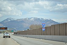
Interstate 84 in Utah
 | ||||
|---|---|---|---|---|
 I-84 highlighted in red | ||||
| Route information | ||||
| Maintained by UDOT | ||||
| Length | 119.77 mi[1] (192.75 km) | |||
| Existed | 1977–present | |||
| Major junctions | ||||
| West end | ||||
| East end | ||||
| Location | ||||
| Counties | Box Elder, Weber, Davis, Morgan, Summit | |||
| Highway system | ||||
| ||||
Interstate 84 (I-84) is a part of the Interstate Highway System that links Portland, Oregon to I-80 near Echo, Utah. The 119.77-mile-long (192.75 km) segment in the U.S. state of Utah is the shortest of any of the three states the western I-84 passes through, and contains the eastern terminus of the highway. I-84 enters Box Elder County near Snowville before becoming concurrent with I-15 in Tremonton. The concurrent highways travel south through Brigham City and Ogden and separate near the Ogden-Hinckley Airport. Turing east along the Davis County border, I-84 intersects U.S. Route 89 (US-89) and enters Weber Canyon as well as Morgan County. While in Morgan County, I-84 passes the Devil's Gate-Weber Hydroelectric Power Plant and Devil's Slide rock formation. Past Morgan, the highway crosses into Summit County, past the Thousand Mile Tree before reaching its eastern terminus at I-80 near Echo.
Construction of the controlled-access highway was scheduled in late 1957 under the designations Interstate 82S and Interstate 80N. The I-82S designation was only applied on paper for about a year, but the I-80N designation was the highway's official designation until 1977 when it was renumbered I-84 by the American Association of State Highway and Transportation Officials. By 1986, construction of the freeway had been completed across the three states. Average traffic in 2012, along the non-concurrent parts of I-84, ranged from as few as 6,655 vehicles traveling along I-84 at the interchange with SR-86 in Henefer, and as many as 18,945 vehicles used the highway at the SR-26 interchange in Riverdale.
Route description[]
Out of the three states that the western portion of I-84 passes through, the 119.77-mile-long (192.75 km) segment in Utah is the shortest. By comparison, the longest stretch of western I-84 through a single state is the 375.17-mile-long (603.78 km) segment in Oregon. I-84 also has a noncontiguous eastern segment that passes through Pennsylvania, New York, Connecticut, and Massachusetts: all four of these segments are shorter than the Utah segment.[1]
Every year, the Utah Department of Transportation (UDOT) conducts a series of surveys on its highways in the state to measure traffic volume. This is expressed in terms of average annual daily traffic (AADT), a measure of traffic volume for any average day of the year. In 2012, UDOT calculated that as few as 6,655 vehicles traveled I-84 at the interchange with SR-86 in Henefer, and as many as 18,945 vehicles used the highway at the SR-26 interchange in Riverdale.[2] Between 27 and 57 percent of the traffic recorded consisted of trucks.[3] These counts are of the portion of the freeway in Utah and are not reflective of the entire Interstate, or of its concurrency with I-15. As part of the Interstate Highway System,[4] the entire route is listed on the National Highway System, a system of roads that are important to the nation's economy, defense, and mobility.[5]
Western segment[]
Crossing the Idaho-Utah state line, I-84 enters Box Elder County and the Curlew Valley near farmland that utilizes center pivot irrigation before intersecting SR-30 at a diamond interchange.[6] The town of Snowville is crossed before passing to the north of the Hansel Mountains and the . The town of Howell, accessible from an interchange with SR-83, lays to the southeast of in the Blue Creek Valley. Access to the Golden Spike National Historic Site is provided by SR-83 south of Howell. The form the southern border of Howell as I-84 continues southeast.[7] Additional center irrigation farmland is passed before giving way to more traditional farmland outside of the city of Tremonton,[6] where a trumpet interchange marks where I-15 turns north towards Malad City and Pocatello.[8] Heading southeast from this interchange, I-84 and I-15 are concurrent for just over 38 miles (61 km).[9]
Concurrency with I-15[]
Concurrent highways I-15/84 continue south, parallel to rail belonging to the Union Pacific Railroad (UP) past the Wellsville Mountain Wilderness, to an interchange at 1100 West in Brigham City, also known as US-91, which once in Brigham City becomes concurrent with US-89 and the two highways travel northeast from Brigham City into Box Elder Canyon towards Logan in the heart of the Cache Valley. US-89 closely parallels I-15/84 east, as the highways pass Willard Bay, the Willard Bay State Park and Bear River Migratory Bird Refuge before crossing into Weber County.[6][7]
Upon entering Weber County the rail line that the highway has paralleled since Tremonton splits off eastwards near Defense Depot Ogden, as the concurrent highways continue south past Farr West and Slaterville before a Southern Pacific Railroad rail line, which traverses the Great Salt Lake on a causeway, crosses under the freeway. The city of Ogden is bypassed by the Interstates, with US-89 serving downtown. US-89 is accessible via interchanges with SR-39, SR-79 and SR-104 in addition to I-84 further southeast. I-84 splits from I-15 at the south end of the Ogden-Hinckley Airport, with I-15 continuing south towards Salt Lake City and Provo.[6][10]
Eastern segment[]

Splitting from I-15 near Roy, I-84 passes between Hill Air Force Base, which is to the south of the highway, and Washington Terrace before clipping the extreme northern portions of Davis County.[10] While in Davis County, I-84 intersects 475 East, also known as the Adams Avenue Parkway,[6] before coming to a hybrid partial cloverleaf/half-diamond interchange with US-89 along the Davis-Weber county line.[10][11]
I-84 follows the Weber River into Weber Canyon, Morgan County, and the Wasatch-Cache National Forest. Once in the canyon, the carriageways of the highway split to accommodate the Devil's Gate-Weber Hydroelectric Power Plant. Following the river south, I-84 exits the forest and enters the county seat of Morgan. Leaving the city the highway turns back east,[6][12] passing Devil's Slide, an unusual rock formation just off the freeway.[13]
Upon entering Summit County, I-84 passes the Thousand Mile Tree, planted by Union Pacific Railroad workers to mark the construction of 1,000 miles (1,600 km) of rail from its origin in Omaha, Nebraska.[14][15] The tree was said to be the only pine tree between Omaha and Salt Lake City.[16] Another tree was planted as the original tree had died in 1900 and was removed in 1926 to during the conversion from single track to double track through the canyon.[17][18] Past the tree the freeway passes through the town of Henefer before terminating at a directional T interchange with I-80 just south of the census-designated place of Echo. Immediately south of the interchange is Echo Reservoir and Echo Dam.[6][19]
History[]

Earlier roads[]
Most of the original routing of what is now I-84 existed as early as 1923; however the portion of now I-84 into Idaho was not yet constructed.[20] In 1926, much of the route was signed as US-30S, from the now eastern terminus at I-80 (US-530 then), northwest into Ogden. Between Ogden and Brigham City, the highway was to be concurrent with US-91, then US-30S split off northwest to the Idaho border.[21] The entire western branch of US-30S was an unimproved road, however the concurrency into Ogden was paved. The remainder of the route to its now terminus was mostly graded with a few improved sections,[22] and by 1937, the entire route was paved.[23]
Current road[]
The first Utah State Route to have the number 84 is what is now known as SR-126. SR-126 was originally numbered SR-84 until the 1977 renumbering of Utah State highways. Previously, the freeway's legislative designation was SR-3.[24] Like the other two main Interstate Highways in Utah, I-15 (the Veterans Memorial Highway) and I-80 (the Purple Heart Trail), I-84 has also been given a special name of "Vietnam Veterans Memorial Highway". House Bill HB275, sponsored by Utah Representative Justin Fawson (R), North Ogden, authorizing the name designation was signed into law by Utah Governor Gary Herbert on March 30, 2015.[25][26] The highway loosely follows the path of the First Transcontinental Railroad.[27] The original routing of US-30S had the highway passing into Idaho west of Black Pine Peak however,[28] the new I-84 was constructed to the east. The original roadways are now numbered SR-30, SR-42 and Idaho State Highway 2847.[6][29]
Interstate 80N | |
|---|---|
| Location | Idaho state line to Echo |
| Existed | 1958–1977[30][31] |
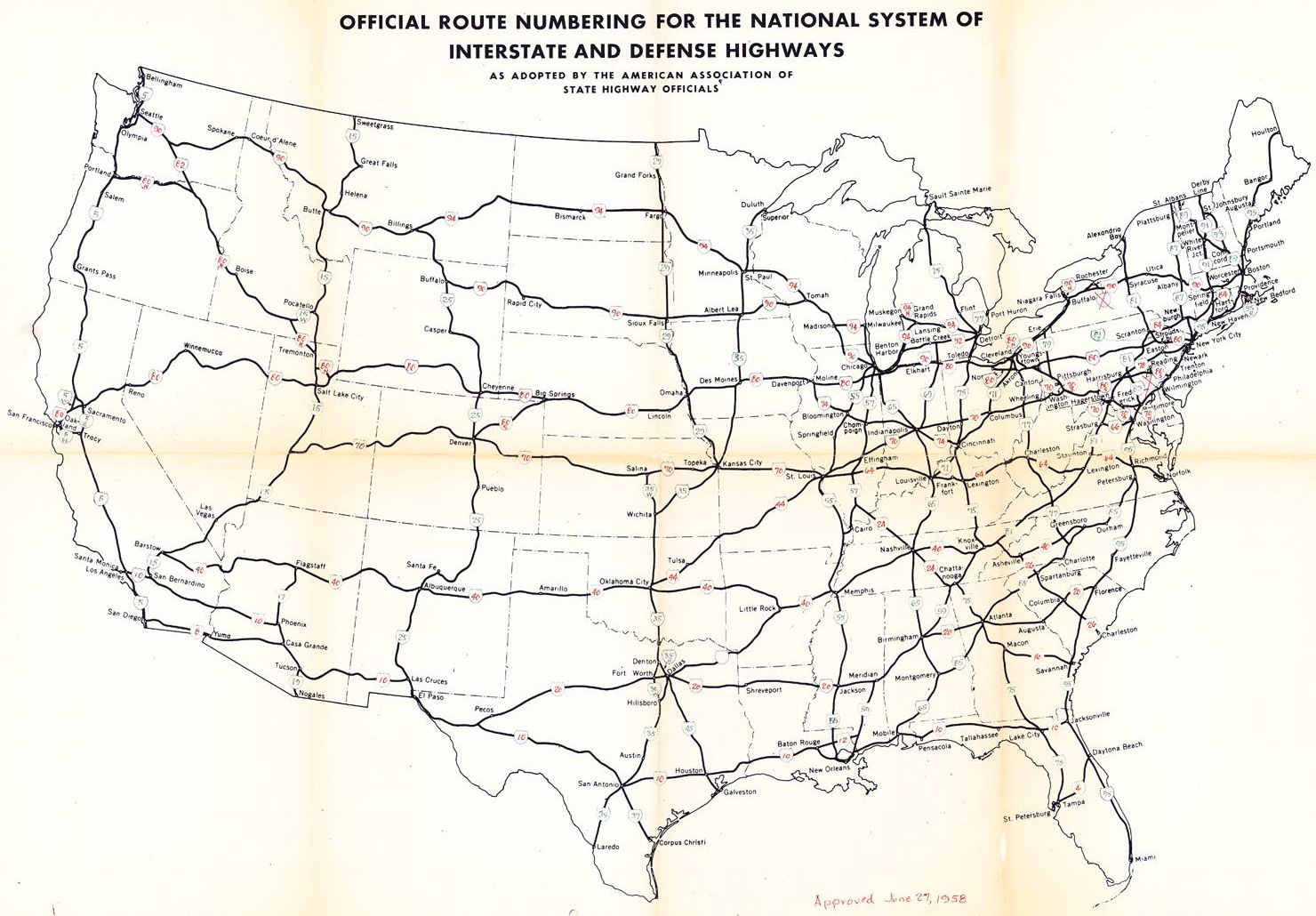
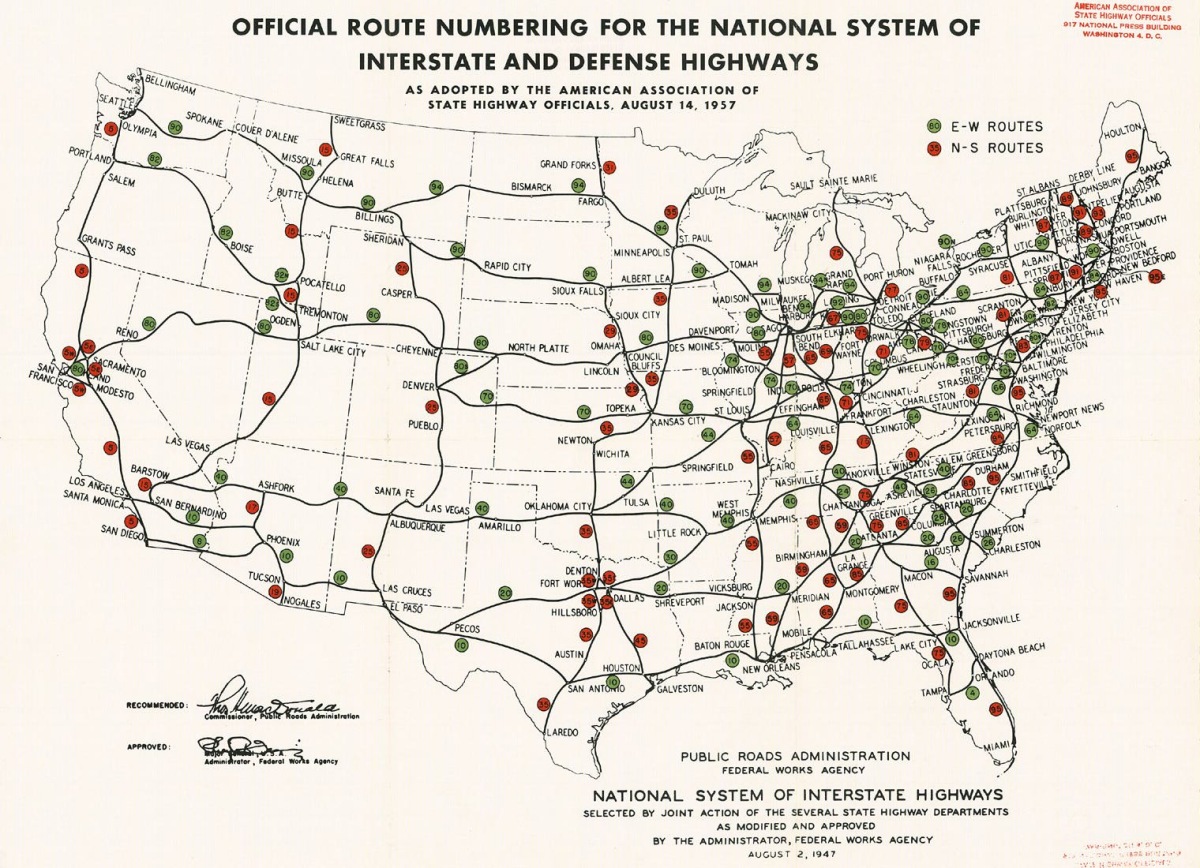
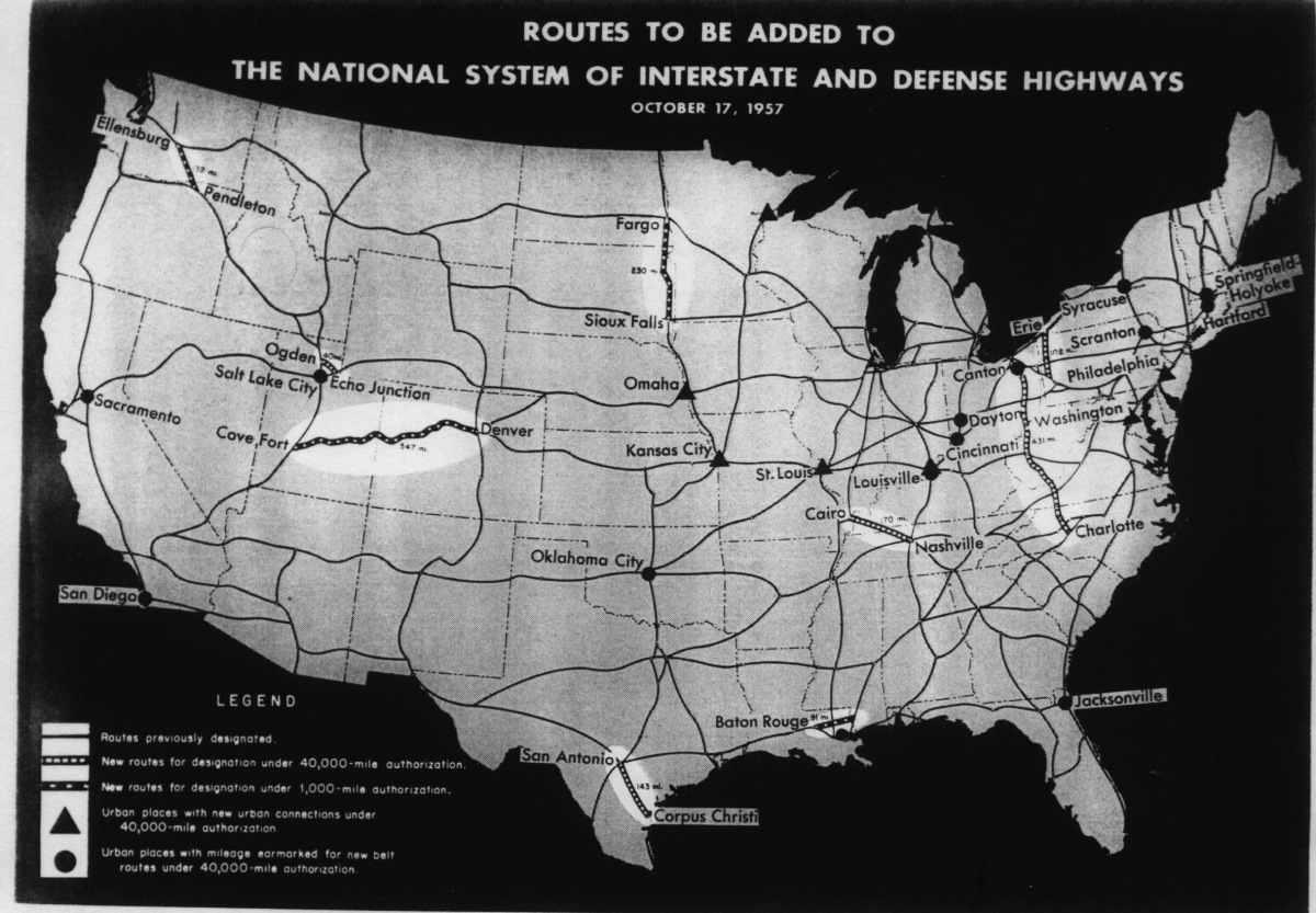
Passage of the Federal Aid Highway Act of 1956 formed the Interstate Highway System,[32] however only the western segment of now I-84 was approved at this time, and a designation of I-82S was assigned to a then unconstructed controlled-access highway across Box Elder County in 1957.[33] The eastern segment of the highway was added later in 1957,[34] and the route was numbered I-80N by 1958.[30] By 1968, portions of the western half of the freeway had been completed, along with the segment between Tremonton and Brigham City. A portion of the freeway was completed around Morgan as well.[35] By 1971, most of the western portions of the freeway had been constructed with two sections remaining that had at-grade intersections. Along the concurrency, there were gaps between Brigham City and Pleasant View, and one small gap near the Devil's Slide.[36]
The I-80N designation was changed to I-84 in 1977 by the American Association of State Highway and Transportation Officials, over objections from the Washington State Department of Transportation and the Idaho Transportation Department, and with the support of UDOT and the Oregon Department of Transportation.[24][31] By 1978, construction of I-84 was complete across most of the three states.[37] In September 1986, the final section of the highway was opened on the 11 miles (18 km) from Tremonton to Blue Creek Summit, following three years of construction that cost $21 million.[38]
In 1994, I-84 was planned to be used to transport low-level radioactive waste from the Idaho National Engineering Laboratory to Waste Isolation Pilot Plant in Carlsbad, New Mexico via Wyoming.[39] This did not start until 1999 however due to the delay in the opening of the New Mexican plant.[40] A $20 million (equivalent to $29.8 million in 2019)[41] reconstruction of the US-89 interchange at the mouth of Weber Canyon was financed partly by the funding obtained by the state in preparation for the 2002 Winter Olympics in 1998,[42] and was scheduled to begin in 2000.[43] Reconstruction of a 10-mile-long (16 km) segment of I-84 between Mountain Green and Morgan was done between 2004 and 2005 at a cost of $19 million (equivalent to $25.2 million in 2019).[41][44] One of the sub-contractors on the job was found guilty of lying about sub-par work done on installation of roadside impact absorbers along this stretch.[45]
Exit list[]
| County | Location | mi[9] | km | Exit | Destinations | Notes | |
|---|---|---|---|---|---|---|---|
| Box Elder | | 0.000 | 0.000 | Continuation into Idaho | |||
| | 4.660 | 7.500 | 5 | West end of SR-30 overlap; former US-30S | |||
| Snowville | 7.125 | 11.467 | 7 | Snowville | |||
| | 11.978 | 19.277 | 12 | Ranch Exit | |||
| | 15.808 | 25.441 | 16 | Hansel Valley | |||
| | 17.385 | 27.978 | 17 | Rattlesnake Pass | |||
| | 20.317 | 32.697 | 20 | Blue Creek | |||
| | 24.457 | 39.360 | 24 | ||||
| Howell | 26.567 | 42.755 | 26 | Access to Golden Spike National Historic Site | |||
| | 32.414 | 52.165 | 32 | Ranch Exit | |||
| | 39.508 | 63.582 | 39 | Garland, Bothwell | |||
| Bothwell Junction | 40.824 | 65.700 | 40 | ||||
| | 42.012 | 67.612 | 41 | West end of I-15 overlap; signed as exit 379 westbound | |||
| I-84 overlaps Interstate 15 for 38.309 mi (61.652 km) | |||||||
| Weber | Riverdale | 81.043 | 130.426 | East end of I-15 overlap; I-15 exit 340; westbound access via exit 81 | |||
| 81.727 | 131.527 | 81 | |||||
| Davis | Uintah | 84.594 | 136.141 | 85 | Adams Avenue | Adams Avenue is a private toll road here | |
| Weber | Uintah Junction | 87.771 | 141.254 | 87 | Signed as exits 87A (south) and 87B (north) westbound | ||
| Morgan | | 91.240 | 146.837 | Rest area (eastbound) | |||
| | 92.339 | 148.605 | 92 | Eastbound exit and westbound entrance | |||
| | 93.904 | 151.124 | Rest area (westbound) | ||||
| | 96.504 | 155.308 | 96 | , Peterson | |||
| Morgan | 103.333 | 166.298 | 103 | ||||
| | 106.173 | 170.869 | 106 | Ranch Exit | |||
| | 108.272 | 174.247 | 108 | ||||
| | 111.313 | 179.141 | 111 | Croydon | Former SR-158 | ||
| | 110.761 | 178.253 | Devil's Slide View Area | ||||
| Summit | | 112.739 | 181.436 | 112 | |||
| Henefer | 115.399 | 185.717 | 115 | ||||
| | 119.773 | 192.756 | 120 | I-80 exit 168; signed as exits 120A (east) and 120B (west); eastern terminus; semi-directional T interchange | |||
1.000 mi = 1.609 km; 1.000 km = 0.621 mi
| |||||||
See also[]
 U.S. Roads portal
 Utah portal
References[]
- ^ a b Adderly, Kevin (January 19, 2012). "Table 1: Main Routes of the Dwight D. Eisenhower National System Of Interstate and Defense Highways". FHWA Route Log and Finder List. Federal Highway Administration. OCLC 47914009. Retrieved December 27, 2013.
- ^ Utah Department of Transportation (2012). Traffic on Utah Highways (PDF) (Report). Utah Department of Transportation. p. 16. Retrieved December 27, 2013.
- ^ Utah Department of Transportation (2012). Truck Traffic on Utah Highways (PDF) (Report). Utah Department of Transportation. p. 15. Retrieved December 25, 2013.
- ^ Slater, Rodney E. (Spring 1996). "The National Highway System: A Commitment to America's Future". Public Roads. 59 (4). Retrieved January 24, 2011.
- ^ Federal Highway Administration (November 18, 2013). National Highway System: Utah (PDF) (Map). 1:772,200. Washington, DC: Federal Highway Administration. Retrieved December 27, 2013.
- ^ a b c d e f g h Google (December 27, 2013). "Interstate 84 Overview" (Map). Google Maps. Google. Retrieved December 27, 2013.
- ^ a b Utah Department of Transportation (2005). Box Elder County (Map). 1:29,040. General Highway Map. Salt Lake City: Utah Department of Transportation. p. 6. Retrieved December 27, 2013.
- ^ Utah Department of Transportation (2005). Box Elder County (Map). 1:29,040. General Highway Map. Salt Lake City: Utah Department of Transportation. p. 7. Retrieved December 27, 2013.
- ^ a b Utah Department of Transportation (January 2, 2013). "Route 84". Highway Reference. Utah Department of Transportation. Retrieved December 27, 2013.
- ^ a b c Utah Department of Transportation (2005). Weber County (Map). 1:22,440. General Highway Map. Salt Lake City: Utah Department of Transportation. p. 1. Retrieved December 27, 2013.
- ^ Utah Department of Transportation (2005). Davis County (Map). 1:22,440. General Highway Map. Salt Lake City: Utah Department of Transportation. Retrieved December 27, 2013.
- ^ Utah Department of Transportation (2005). Morgan County (Map). 1:29,040. General Highway Map. Salt Lake City: Utah Department of Transportation. Retrieved December 27, 2013.
- ^ Powell, Allan Kent (2003). The Utah Guide (3rd ed.). Golden, Colo.: Fulcrum Publishing. p. 84. ISBN 9781555911140. Retrieved December 27, 2013.
- ^ Leng, Sir John (1877). America in 1876: Pencillings During a Tour. Dundee, Scotland: Dundee Advertiser Office. p. 109. OCLC 1658991. Retrieved December 28, 2013.
- ^ Hayden, F.V.; Davis, Daniel M. "Sun Pictures of Rocky Mountain Scenery, Photographic Collection". Utah State University Special Collections and Archives. Archived from the original on January 12, 2007. Retrieved January 6, 2007.
- ^ Wilcox, H. K. W. (1870). "Famous Trees". Appleton's Journal of Literature, Science and Art. D. Appleton & Company: 675. OCLC 8241845. Retrieved December 27, 2013.
- ^ Morgan County Historical Society (2007). "Historic Sites". Morgan County Historical Society. Retrieved December 27, 2013.
- ^ Smith, Linda H. (1999). A History of Morgan County (PDF). Utah Centennial County History. Salt Lake City: Utah State Historical Society. p. 260. ISBN 978-0913738368. Retrieved December 27, 2013.
- ^ Utah Department of Transportation (2005). Summit County (Map). 1:22,440. General Highway Map. Salt Lake City: Utah Department of Transportation. p. 3. Retrieved December 27, 2013.
- ^ Matthews-Northrup Works (1923). Map of Strategic Routes between Salt Lake City, Utah and California (Map). 1:2,500,000. Lincoln Highway Association. OCLC 36006905. Retrieved December 27, 2013.
- ^ Bureau of Public Roads & American Association of State Highway Officials (November 11, 1926). United States System of Highways Adopted for Uniform Marking by the American Association of State Highway Officials (Map). 1:7,000,000. Washington, DC: U.S. Geological Survey. OCLC 32889555. Retrieved November 7, 2013 – via Wikimedia Commons.
- ^ Rand McNally (1926). "Utah (northern)" (Map). Rand McNally Junior Road Map. 1:237,600. Chicago: Rand McNally. OCLC 39724225. Retrieved December 27, 2013.
- ^ Texaco; Rand McNally (1937). Texaco Road Map Idaho, Montana, Wyoming (Map). 1:1,774,080. Chicago: Rand McNally. §§ L5–M7. OCLC 52950564. Retrieved December 26, 2013.
- ^ a b Utah Department of Transportation (November 2007). "Route 84". Highway Resolutions. Utah Department of Transportation. Retrieved September 21, 2008.
- ^ "HB0275".
- ^ Utah Department of Transportation. Utah's Special Highways (Map). Not to scale. Salt Lake City: Utah Department of Transportation. Retrieved December 28, 2013.
- ^ United States Congress (1969). Congressional Record. Volume 115, Part 2. Government Printing Office. p. 29631. Retrieved December 27, 2013.
|volume=has extra text (help) - ^ Shell Oil Company; H.M. Gousha Company. Highway Map of Utah (Map). 1:1,203,840. § C2. Retrieved December 26, 2013.
- ^ Idaho Transportation Department. Idaho Official State Highway Map (PDF) (Map). Scale not given. Boise: Idaho Transportation Department. §§ M5–M6. Retrieved December 26, 2013.
- ^ a b Public Roads Administration (June 27, 1958). Official Route Numbering for the National System of Interstate and Defense Highways as Adopted by the American Association of State Highway Officials (Map). Scale not given. Washington, DC: Public Roads Administration. Retrieved December 27, 2013.
- ^ a b "Interstate 80 to become 84". Deseret News. Salt Lake City. August 13, 1977. pp. A3. OCLC 367900151.
- ^ Lewis, Tom (1997). Divided Highways: Building the Interstate Highways, Transforming American Life. New York: Viking. pp. 120–1, 136–7. ISBN 0-670-86627-X.
- ^ Public Roads Administration (August 14, 1957). Official Route Numbering for the National System of Interstate and Defense Highways as Adopted by the American Association of State Highway Officials (Map). Scale not given. Washington, DC: Public Roads Administration. Retrieved December 26, 2013.
- ^ Public Roads Administration (October 17, 1957). Routes to be Added to the National System of Interstate and Defense Highways (Map). Scale not given. Washington, DC: Public Roads Administration. Retrieved December 27, 2013.
- ^ Union Oil Company of California; Rand McNally & Co. (1968). Western United States (Map). 1:3,104,640. §§ H7–H8.
- ^ State Road Commission of Utah; Rand McNally (1971). Utah Official Highway Map (Map). 1:1,102,464. Salt Lake City: State Road Commission of Utah. §§ B4-C5.
- ^ "Other Projects Get $5 Billion in Interstate Road 'Trades': Fewer Than 11,000 Miles Complete". The New York Times. December 3, 1978. OCLC 1645522. ProQuest 123565578.
- ^ "UDOT completes highway". The Spectrum. St. George, Utah. UPI. September 21, 1986. p. 2. Retrieved June 22, 2018 – via Newspapers.com.

- ^ "N-Waste shipments to Pass Through N. Utah in 1994". The Salt Lake Tribune. Associated Press. September 1, 1993. p. C3. OCLC 8086936. ProQuest 288598169.
- ^ "Judge's Ruling May Open Path Through Utah for Nuke Waste". The Salt Lake Tribune. Associated Press. March 23, 1999. p. A8. OCLC 8086936. ProQuest 288903298.
- ^ a b Thomas, Ryland; Williamson, Samuel H. (2020). "What Was the U.S. GDP Then?". MeasuringWorth. Retrieved September 22, 2020. United States Gross Domestic Product deflator figures follow the Measuring Worth series.
- ^ Gorrell, Mike (October 28, 1998). "Fed Funds Pave Way For Roads; Most of $90M transportation grant will go to Olympic highway work; Grant Provides $75M for Olympic Roads". The Salt Lake Tribune. p. A1. OCLC 8086936. ProQuest 288847913.
- ^ Gorrell, Mike (October 19, 1999). "As Feds Divvy Up Last of Highway Funds, SLOC Holds Breath". The Salt Lake Tribune. p. B2. OCLC 8086936. ProQuest 288909759.
- ^ "Granite Construction Awarded $19.0 Million Highway Reconstruction Project in Utah" (Press release). PR Newswire. December 22, 2003. OCLC 44297296. ProQuest 448224430.
- ^ Manson, Pamela (July 8, 2009). "Orem construction company admits lying". The Salt Lake Tribune. OCLC 8086936. ProQuest 280593335.
External links[]
Route map:

| ( • help)
|
 Media related to Interstate 84 in Utah at Wikimedia Commons
- Interstate 84 in Utah on AARoads
- Interstate Highways in Utah
- Interstate 84 (Oregon–Utah)
- Transportation in Box Elder County, Utah
- Transportation in Weber County, Utah
- Transportation in Davis County, Utah
- Transportation in Morgan County, Utah
- Transportation in Summit County, Utah
- Central Overland Route
- U.S. Route 30S