Inverlussa
| Inverlussa | |
|---|---|
 | |
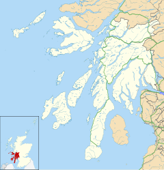 Inverlussa Location within Argyll and Bute | |
| Council area | |
| Country | Scotland |
| Sovereign state | United Kingdom |
| Police | Scotland |
| Fire | Scottish |
| Ambulance | Scottish |

Inverlussa is a hamlet 1 mile (1.6 km) southwest of Ardlussa and 14 miles from Craighouse at the mouth of on the east coast of the island of Jura, in the council area of Argyll and Bute, Scotland.[1] It is largely a linear settlement.[2]
History[]
The name "Inverlussa" is Gaelic/Norse and means "The mouth of the bright river".[3]
Landmarks[]
Historically there was a small chapel at Inverlussa.[4]
References[]
- ^ "Inverlussa". Gazetteer for Scotland. Retrieved 22 July 2020.
- ^ "Island of Jura" (PDF). Argyll and Bute Council. Retrieved 6 August 2020.
- ^ "Placenames F-J" (PDF). Scottish Parliament. Retrieved 22 July 2020.
- ^ "Argyll: Mid Argyll & Cowal, medieval & later monuments". Royal Commission on the Ancient and Historical Monuments of Scotland, H.M. Stationery Office-Argyll. 1992. p. 336.
| Wikimedia Commons has media related to Inverlussa. |
| Settlements |  | |
|---|---|---|
| Other "non OS settlements" | ||
| Surrounding islands |
| |
| Other places | ||
This Argyll and Bute location article is a stub. You can help Wikipedia by . |
Categories:
- Hamlets in Argyll and Bute
- Villages on Jura, Scotland
- Argyll and Bute geography stubs