Isla de la Luna
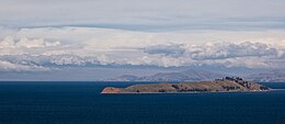 View of Isla de la Luna from Isla del Sol | |
| Geography | |
|---|---|
| Location | Lake Titicaca |
| Coordinates | 16°02′25″S 69°04′15″W / 16.04028°S 69.07083°WCoordinates: 16°02′25″S 69°04′15″W / 16.04028°S 69.07083°W |
| Area | 1.05 km2 (0.41 sq mi) |
| Coastline | 6 km (3.7 mi) |
| Highest elevation | 3,925 m (12877 ft) |
| Administration | |

Isla de la Luna (translation: "Island of the Moon") is an island in La Paz Department, Bolivia. It is situated in Lake Titicaca, east of Isla del Sol ("Island of the Sun"). Legends in Inca mythology refer to the island as the location where Viracocha commanded the rising of the moon. Archeological ruins of an Inca nunnery were found on the eastern shore.[1]

References[]
- ^ Bolivia, Lonely Planet 2007, ISBN 1-74104-557-6
| Wikimedia Commons has media related to Isla de la Luna, Bolivia. |
| hide Authority control | |
|---|---|
| General |
|
| National libraries | |
This La Paz Department geography article is a stub. You can help Wikipedia by . |
Categories:
- Lake islands of Bolivia
- Islands of Lake Titicaca
- Landforms of La Paz Department (Bolivia)
- La Paz Department (Bolivia) geography stubs