Isla de sa Porrassa
 Isla de Sa Porrassa | |
 Isla de sa Porrassa Location in Spain | |
| Geography | |
|---|---|
| Coordinates | 39°30′13″N 2°32′42″E / 39.50361°N 2.54500°ECoordinates: 39°30′13″N 2°32′42″E / 39.50361°N 2.54500°E |
| Archipelago | Baleric Islands |
| Length | 0.4 km (0.25 mi) |
| Highest elevation | 36 m (118 ft) |
| Autonomous Community | Balearic Islands |
| Comarca | Serra de Tramuntana |
| Municipality | Calvià |
| Demographics | |
| Population | 0 |

Isla de sa Porassa is located in the bay of the village of Magaluf, Majorca, Spain.
Features[]
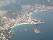
Measuring over 400 meters (1,300 ft) across at its widest point, the island is a feature at the heart of Magaluf Bay. It is 36 m (118 ft) above sea level.[1] The island is uninhabited, but visited during the summer season by many holidaymakers, either swimming, on personal water craft or on pedalboat (like S & B) from Magaluf Beach.
Since 2014, British holidaymakers have unofficially dubbed the rock "Big Swillers Island" due to it being seen as a rite of passage for young party-goers to try to reach the island whilst intoxicated. However local police have advised against this due to the risk it entails. [2]
References[]
- ^ Publications. Vol. 151 (Digitized May 5, 2009 ed.). United States. Hydrographic Office. 1920. p. 221.
- ^ "Magalluf Guide". Archived from the original on 27 June 2010. Retrieved 6 July 2010.
External links[]
This article about a location in the Balearic Islands is a stub. You can help Wikipedia by . |
- Islets of Mallorca
- Calvià
- Balearic Islands geography stubs