Isperih Municipality
Isperih Municipality
Община Исперих | |
|---|---|
Municipality | |
 Isperih Municipality within Bulgaria and Razgrad Province. | |
| Coordinates: 43°42′N 26°49′E / 43.700°N 26.817°ECoordinates: 43°42′N 26°49′E / 43.700°N 26.817°E | |
| Country | |
| Province (Oblast) | Razgrad |
| Admin. centre (Obshtinski tsentar) | Isperih |
| Area | |
| • Total | 402.24 km2 (155.31 sq mi) |
| Population (December 2009)[1] | |
| • Total | 22,916 |
| • Density | 57/km2 (150/sq mi) |
| Time zone | UTC+2 (EET) |
| • Summer (DST) | UTC+3 (EEST) |

Isperih Municipality (Bulgarian: Община Исперих) is a municipality (obshtina) in Razgrad Province, Northeastern Bulgaria, located in the Ludogorie geographical region part of the Danubian Plain. It is named after its administrative centre - the town of Isperih.
The municipality embraces a territory of 402 km² with a population of 22,916 inhabitants, as of December 2009.[1]
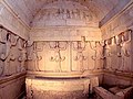
The area is best known with the 3rd century BC Thracian Tomb of Sveshtari near the village of the same name.
Settlements[]

Isperih Municipality includes the following 24 places (towns are shown in bold):
| Town/Village | Cyrillic | Population[2][3][4] (December 2009) |
|---|---|---|
| Isperih | Исперих | 9,017 |
| Белинци | 480 | |
| Бърдоква | 289 | |
| Делчево | 450 | |
| Драгомъж | 355 | |
| Духовец | 542 | |
| Голям Поровец | 628 | |
| Китанчево | 1,549 | |
| Конево | 131 | |
| Къпиновци | 211 | |
| Лудогорци | 849 | |
| Лъвино | 1,066 | |
| Малко Йонково | 380 | |
| Малък Поровец | 388 | |
| Печеница | 299 | |
| Подайва | 1,566 | |
| Райнино | 550 | |
| Свещари | 632 | |
| Sredoseltsi | Средоселци | 321 |
| Старо селище | 367 | |
| Тодорово | 757 | |
| Vazovo | Вазово | 986 |
| Яким Груево | 277 | |
| Йонково | 826 | |
| Total | 22,916 |
Demography[]
The following table shows the change of the population during the last four decades.
| Isperih Municipality | ||||||||
|---|---|---|---|---|---|---|---|---|
| Year | 1975 | 1985 | 1992 | 2001 | 2005 | 2007 | 2009 | 2011 |
| Population | 35,838 | 34,902 | 27,936 | 25,287 | 24,141 | 23,601 | 22,916 | ... |
| Sources: Census 2001,[5] Census 2011,[6] „pop-stat.mashke.org“,[7] | ||||||||
Religion[]
According to the latest Bulgarian census of 2011, the religious composition, among those who answered the optional question on religious identification, was the following:
See also[]
- Provinces of Bulgaria
- Municipalities of Bulgaria
- List of cities and towns in Bulgaria
References[]
- ^ Jump up to: a b (in English) Bulgarian National Statistical Institute - Bulgarian provinces and municipalities in 2009 Archived 2010-11-13 at the Wayback Machine
- ^ (in English) Bulgarian National Statistical Institute - Bulgarian towns in 2009 Archived 2010-11-13 at the Wayback Machine
- ^ (in English) Bulgarian National Statistical Institute - Bulgarian villages under 1000 inhabitants - December 2009
- ^ (in English) Bulgarian National Statistical Institute - Bulgarian Settlements 1000-5000 inhabitants - December 2009
- ^ (in English)National Statistical Institute - Census 2001
- ^ „pop-stat.mashke.org“
- ^ "Population of Bulgarian divisions". Pop-stat.mashke.org. 2011-02-01. Retrieved 2012-03-28.
- ^ "Religious composition of Bulgaria 2011". pop-stat.mashke.org.
External links[]
- Official website (in Bulgarian)
| show Places adjacent to Isperih Municipality |
|---|
| show Authority control |
|---|
- Municipalities in Razgrad Province