Israel National Trail
| Israel National Trail | |
|---|---|
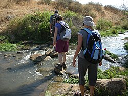 Hikers on the Israel National Trail | |
| Length | 1,025 kilometres (636.9 mi) |
| Location | Israel |
| Established | 1995 |
| Trailheads | North: Dan, South: Eilat |
| Use | Hiking |
| Hiking details | |
| Season | Early spring[1] |
| Months | November to May[1] |
| Website | http://www.israeltrail.net/ |
The Israel National Trail, (Hebrew: שביל ישראל, Shvil Yisra'el) is a hiking path that was inaugurated in 1995. The trail crosses the entire country of Israel.[2] Its northern end is at Dan, near the Lebanese border in the far north of the country, and it extends to Eilat at the southernmost tip of Israel on the Red Sea, a length of 1,015 km (631 mi).[3][4]
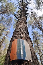
The trail is marked with three stripes (white, blue, and orange), and takes an average of 45-60 days to complete.[5] It does not enter the Golan Heights or the West Bank.[contradictory][6]
The Israel National Trail has been listed in National Geographic's 20 most "epic trails." It is described as a trail that "delves into the grand scale of biblical landscapes as well as the everyday lives of the modern Israeli."[7]
Since January 2016, the Israel National Trail can be explored on Google Street View. Israel National Trail on Google Street View.
History[]
The Israel National Trail (INT) is the brainchild of Avraham Tamir, a journalist and hiker who hiked the Appalachian Trail in the late 70's and Ori Dvir, hiker, educator and one of the founders of The Society for Protection of Nature in Israel (SPNI). The INT is over 1000 kilometers long and is marked, managed and maintained by The Israel Trails Committee which also blazes, marks and maintains the 15,000 kilometers of hiking trails all over Israel.
The Israel National Trail was officially inaugurated by then President of Israel, Ezer Weizmann in 1994. One of its purposes is to give Israelis a way to experience the entire breadth of the land firsthand. The various sections of the trail have been added progressively during this development.

In 2003 a portion of the trail was diverted from the Sharon and now runs along the coast. The reasons for the change were the development of Highway 6, avoiding the security risk of walking along the Green Line and the desire to add to the trail sections with city and sea views.
According to statistics compiled in 2010, only 4 out of 10 hikers complete the entire trail.[5] Recognizing this, the planners divided it into smaller sections that can be hiked separately. Some sections can be completed in day trips or over the weekend.[8]
Because the southern section of the trail passes through many isolated areas, hikers cache supplies of food and water at designated points on the trail before beginning the hike or pay for supplies to be delivered.
Hikers can seek help from "trail angels". For example, at Kibbutz Yagur, a soldier leaves the key to her room for hikers who need a place to sleep and a farmer in Hadera forest offers sleeping quarters in exchange for a day's work.[9]
Awards and recognition[]
In 2012, National Geographic magazine included the trail on its best hiking trail list. It was praised for "connecting to something that often gets lost in all the headlines: the sublime beauty of the wilderness of the Middle East." According to the magazine, "the joy of the trail is meeting the Israelis hiking it, and spending some time in small kibbutzim where local people take hikers into their homes."[10]
Route[]


The trail is a continuous footpath across the entire country of Israel. It mostly consists of dirt tracks, however, occasionally it includes quiet roads or pavements. The path is frequently marked by its unique striped markers. These are often painted on rocks and trees, or with signs and plates.
The trail is walked either North-to-South or South-to-North, both directions are common. However, the North-to-South is more frequently taken. Therefore a description of the route in that direction follows.
Upper Galilee[]
The official start of the trail is in Kibbutz Dan, located behind the . It proceeds to pass through Tel Dan Nature Reserve, and Senir National Park. Passing around the city of Kiryat Shmona, it goes near Tel Hai, where it passes by a memorial to Joseph Trumpeldor.[11]
The path in this area is elevated, providing views of the Hula Valley, a part of the Great Rift Valley. Further along, the path reaches Nabi Yusha fort/Metzudat Koach, and then a shrine, Al-Nabi Yusha' (Prophet Joshua).
The trail continues up to Mount Meron. It passes by a rock formation known as Elijah's Chair, and the archaeological site of Khirbet Shema. Further, the trail sees exposed pipes of the National Water Carrier of Israel. It then passes by the elevated city of Safed, although it does not enter.
Lower Galilee[]
Now at a lower elevation, the route reaches close to the Sea of Galilee, at the town of Migdal. It then ascends briefly onto Mount Arbel, with views of the cliffs and natural caves below. From here, the route comes nearby to the Horns of Hattin, where the Battle of Hattin took place. Shortly afterwards, the route goes through Tiberias, the city directly next to the Sea of Galilee.
After following it for a while, the route departs from the Sea of Galilee, at Yardenit Baptismal Site, onto the Jordan River, which is follows very briefly. The route passes by what were the villages of Awlam and Sirin, as well as the archaeological site of .
The route then continues over Mount Tabor, located at the top is the Church of the Transfiguration. After descending, the route again ascends, over , at the top of which is a monument to mark the silver wedding anniversary of Queen Elizabeth II and Prince Phillip. Shortly after, it passes by the Nazareth Iris Nature Reserve.
Here the route comes close to, but avoids the city of Nazareth, instead, it goes through Nof HaGalil (Nazareth Illit). After leaving, it passes by the archaeological site of Sepphoris (Zippori). Next passing by the ruins of a water mill, Tahanat Hanezirim.[11]
Carmel and the Coast[]
The route passes through Kibbutz Yagur, to then enter, with a very steep ascent, Mount Carmel National Park. After crossing Mount Carmel itself, it passes by Isfiya, and then numerous other mountains. It then descends at the prehistoric Etzba Cave, and passes by the artist's colony of Ein Hod.
The route now turns south, and after passing many more prehistoric caves, it goes by the town of Zikhron Ya'akov. Shortly after, the route reaches an ancient Roman aqueduct, to then reach the Mediterranean Sea, at Jisr az-Zarqa. Along the coast a very short way, the route goes by Caesarea Maritima, the vast ruins of an ancient Roman city.
Going further south, the route goes through the city of Hadera. Afterwards, it crosses the river Nahal Alexander, going through the national park of the same name. Near here the route passes Hirbat Samara, the ruins of a building used by Ottoman customs officers. Next, the route passes the city of Netanya, on the coast, then crosses Nahal Poleg River.
Further along the coast, the route passes by the ruins of the ancient city of Apollonia–Arsuf. Shortly afterwards, it passes by Sidna Ali Mosque, to then go by the city of Herzliya. The route then enters Tel Aviv, where it turns east, away from the coast.[11]
Tel Aviv to Jerusalem[]
The route turns at the mouth of the Yarkon River, which it follows for a while through Yarkon Park. Passing a British army Pillbox by a railway, it then passes into Yarkon Springs National Park. It then departs the river near the city of Rosh HaAyin.
The route goes by the Roman mausoleum of Hirbat Mazor. After a short while, it passes through the archaeological site of Tel Hadid. Next, it passes through , then passing nearby to the Roman ruins of Hirbat Anava and Hirbat Ragav. Further south, the route goes by Latrun Monastery, an old Crusader castle, and the village of Neve Shalom.
The route now begins to ascend, into the Judean Mountains National Park. Walking along Shayarot ridge, views are provided onto Highway 1, the main road from Tel Aviv to Jerusalem. The route follows Burma Road, a makeshift road used during the 1948 Siege of Jerusalem by Palmach soldiers of the Harel Brigade; passing by many military posts nearby. Shortly it passes by Bnei Brit Cave, a memorial dedicated to victims of the Holocaust.
Further east, the route goes through what was the village of Sataf, and then along Nahal Sorek. Shortly the route reaches as close as it gets to Jerusalem; from here, a separate trail, the Jerusalem Trail can be taken for a two-day site trip to see the city. The route passes by Yad Kennedy; a memorial to John F. Kennedy, and Hirbat Khanot, an old traveller's stop.[11]
Jerusalem to the Negev[]
Now pushing away from Jerusalem, the path climbs up to Azekah, a historical ruin on top of a hill. Continuing south, the route goes over a hill, with the ruin of Tel Goded on top. Onward, the route leads into Beit Guvrin National Park; through the ancient town of Eleutheropolis/Beit Guvrin. The route passes nearby to Tel Maresha, ruins of an ancient city. Further on, the route passes through the archaeological site of Tel Lachish.
The route follows the river of Nahal Adora'im it breaks away at the ruins of Tel Keshet, and then through Tel Nagila. It passes through , then following the river of Nahal Shikma. Shortly afterwards, it goes through , to enter the kibbutz of Lahav; within is the Joe Alon Centre and Museum of Bedouin Culture. Just leaving the kibbutz is Hirbat Rimon.
Later the route goes through Yatir Forest, the largest forest in Israel. It passes through Amasa, and then up to Mount Amasa, the second-highest point on the trail, at 859 m.
Heading east onto the Arad Plateau, the route passes through the archaeological site of Tel Arad, to then pass enter the city of Arad itself.[11]
Negev[]
Leaving the city, the route passes into The Negev Desert. It goes over Mount Qina, and then along the river of Nahal Kanfan. Much later, it passes through the Roman archaeological site of . Heading south, it reaches an observation point on the rim of HaMakhtesh HaKatan, the first of the three Makhtesh the trail sees; it passes through and comes close to the gap (centre).
Later, the route passes through Mezad Tzafir, an ancient Roman stronghold that was a part of the Limes (frontier). It follows for a short while, along which is the , the highest dry waterfall in Israel, then passing another Roman stronghold, Meizad Yorkeam.
Next, the route climbs , the collapsed southern rim of HaMakhtesh HaGadol, and then follows Nahal Afran. It then enters the Zin Valley, to cross Nahal Zin. It reaches the peak of Mount Akev, the spring of Ein Akev, and the river of Nahal Akev. It then passes through .
Further along, it passes by Mezad Mahmal, a fort used to protect spice trading routes. Then it enters the town of Mizpe Ramon.
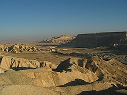
Mizpe Ramon is on the edge of Makhtesh Ramon, the largest Makhtesh in the world. The route enters, taking many days to cross it, and comes close to , the deepest point. After leaving the Makhtesh, it passes by the ancient caravanserai of Moa, and goes through both Barak and Vardit Canyons. It passes Kasui Sand Dunes, then into Timna Valley Park, with Mount Timna and Solomons Pillars, all within Timna Valley.
Lastly, the route reaches Eilat, on the Red Sea, the final destination of the trail and its southern-most point.[11]
Cultural references[]
The trail is featured prominently in Israeli author David Grossman's 2008 novel To the End of the Land. In that story the mother of an Israeli soldier takes to the trail to occupy and distract herself while her son is engaged in a military operation.
See also[]
- Tourism in Israel
- Geography of Israel
- List of long-distance footpaths
- Derech HaTeva
- Wildlife of Israel
- Sea to sea trail
- Jerusalem Trail - the extension of the trail into Jerusalem
References[]
 Media from Wikimedia Commons
 Travel guides from Wikivoyage
 Data from Wikidata
- ^ Jump up to: a b Schnitzspahn, Doug. "World's Best Hikes: Epic Trails". National Geographic. Retrieved June 16, 2013.
- ^ "Israel National Trail". Society for the Protection of Nature in Israel. Retrieved 21 April 2013.
- ^ National Geographic names Israel National Trail as one of world's best, Haaretz
- ^ Google Street View cameras to bring Israel National Trail alive, Jerusalem Post
- ^ Jump up to: a b Porcupines, Emperors, and the New Middle East, Eretz Magazine
- ^ Hasson, Maya (May 12, 2010). "Hiking the Israel National Trail". NBC News. Associated Press. Retrieved July 31, 2010.
- ^ Udasin, Sharon (August 13, 2012). "'National Geographic' calls Israel Trail 'epic'". The Jerusalem Post. Retrieved August 13, 2012.
- ^ Hiking the Israel Trail
- ^ "Israeli Life: Country Road, Take Me Home". Archived from the original on 2011-02-06. Retrieved 2011-04-13.
- ^ National Geographic names Israel National Trail as one of world's best, Haaretz
- ^ Jump up to: a b c d e f Saar, Jacob (2011). Israel National Trail and the Jerusalem Trail (Hike the Land of Israel). Yagil Henkin, Dany Gaspar (2nd ed.). Israel: Eshkol. ISBN 978-965-91249-4-7. OCLC 754709823.
Further reading[]
- Bortoletto, Linda (2019). Le Chemin des anges - Ma traversée d’Israël à pied, Payot, ISBN 2228924652, in French language
- Galblum Pex, Judith (2007). Walk the land : a journey on foot through Israel. Greeley, CO: Cladach Publishing. ISBN 978-0-9759619-5-7.
- Green, Aryeh (2018). My Israel Trail, Cedar Fort, ISBN 978-1462122011
- Saar, Jacob; Henkin, Yagil (2020). Israel National Trail (Hike the Land of Israel). Eshkol Publishing. p. 200. ISBN 978-96542059-1-7.
External links[]
- The INT Experience - Everything about the INT, in English
- Hiking the Israel National Trail - English language resources
- Der Israel Trail - German/ English resources
- The trail in Google maps
- Shvil Israel at SPNI Israel National Trail at the Society for the Protection of Nature in Israel website (Hebrew)
- Israel National Trail Hiking Journals - English
- Israel National Trail - English Resources
Coordinates: 31°23′52″N 34°51′41″E / 31.39778°N 34.86139°E

| Authority control |
|---|
- Geography of Israel
- Hiking trails in Israel
- Tourism in Israel