Isthmus of Perekop
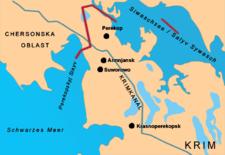
The Isthmus of Perekop, litteraly Isthmus of the Trench (Ukrainian: Перекопський перешийок; transliteration: Perekops'kyy pereshyyok; Russian: Перекопский перешеек; transliteration: Perekopskiy peresheek, Crimean Tatar: Or boynu, Turkish: Orkapı; Greek: Τάφρος; transliteration: Taphros) is the narrow, 5–7 kilometres (3.1–4.3 mi) wide strip of land that connects the Crimean Peninsula to the mainland of Ukraine. The isthmus projects between the Black Sea to the west and the Sivash to the east. The isthmus takes its name of "Perekop" from the Tatar fortress of Or Qapi.
The border between Ukraine's Autonomous Republic of Crimea and Kherson Oblast runs through the northern part of the isthmus. Since the Russian military annexation of Crimea in 2014, this is also the de facto northern border of the Russian Republic of Crimea. The cities of Perekop, Armyansk, and Krasnoperekopsk are situated on the isthmus. The North Crimean Canal ran through the isthmus, supplying Crimea with fresh water from the Dnieper River. Ukraine closed the canal in 2014, and the water supply was replaced by other local and Russian sources.
South of Perekop lie rich salt ores which remain very important commercially for the region.
Name[]
The name Taphros in Greek means a dug-out trench, per a defensive trench dug between the Azov sea and the Black sea; there also appears to have been a town in the vicinity of the same name.[1] The Crimean Tatar name of Or Qapı adopts the Greek in the Crimean Tatar language meaning Or=trench and Qapı=gate, and Perekop in the Slavic languages literally means a dug-out.
History[]
The strategic and commercial value of this area, together with the strategic value of being the gateway to Crimea, has made the isthmus the location of some particularly fierce battles. From antiquity through the Byzantine era the Greeks fortified the area, and so subsequently did the Crimean Tatars. In the 15th century the area became a colony of the maritime Republic of Genoa. In 1783 the area became a part of the Russian Empire, which made Perekop a county center of Tavriia gubernia.[2][3] In 1954, together with Crimea it was transferred to the Ukrainian Soviet Republic.
In November 1920, during the Russian Civil War, a battle was fought here between Red Army and the White troops of Pyotr Wrangel, who was in control of the Crimea. The Red Army turned out victorious, but 140,000 civilians fled over the Black Sea to Istanbul.
During World War II, the combined forces of German and Romanian troops under the command of Erich von Manstein entered Crimea through the Isthmus of Perekop. The battle of the isthmus lasted five days from 24 September 1941 before the isthmus was secured by the Axis forces. On October 27 the Axis forces advanced further into Crimea, leading to the Battle of Sevastopol. On 9 May 1944, the Red Army regained control of Crimea (The Crimean Offensive (8 April – 12 May 1944)).
On 2 March 2014, it was reported that Russian troops were digging trenches along the border between Crimea and Ukraine, which runs across the isthmus.[4] Soon after, this became a de facto border between Russian-controlled Crimea and the rest of Ukraine.
References[]
- ^ Milner, Thomas. The Crimea: Its Ancient and Modern History: The Khans, the Sultans, and the Czars, Nabus Press, 2010, p. 6.
- ^ Danylo Husar Struk (15 December 1993). Encyclopedia of Ukraine: Volume III: L-Pf. University of Toronto Press, Scholarly Publishing Division. p. 2488. ISBN 978-1-4426-5125-8.
- ^ J. Murray. Handbook for Travellers in Russia, Poland, and Finland. Рипол Классик. p. 277. ISBN 978-1-147-56625-3.
- ^ "Ukraine orders full military mobilisation over Russia moves". BBC News. Retrieved March 2, 2014.
Coordinates: 46°08′58″N 33°40′20″E / 46.14944°N 33.67222°E


| show Authority control |
|---|
- Isthmuses of Crimea