Itoshino Station
This article needs additional citations for verification. (November 2019) |
Itoshino Station 愛し野駅 | |
|---|---|
 Itoshino Station | |
| Location | Tanno-machi, Kitami, Hokkaido (北海道北見市端野町) Japan |
| Operated by | JR Hokkaido |
| Line(s) | Sekihoku Main Line |
| Other information | |
| Station code | A62 |
| History | |
| Opened | 1986 |
Itoshino Station (愛し野駅, Itoshino-eki) is a railway station located in the third ward of Tanno, a suburb of Kitami city in Hokkaidō, Japan, and services the Sekihoku Main Line operated by JR Hokkaidō.[1][2][3][4]
Station structure[]
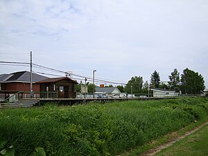
The station is above ground, and consists of a single platform alongside the railway track. Trains operate in both directions along the line. The waiting room is constructed in the style of a small log cabin. The station itself is mostly used by students attending the nearby senior high school.
Station environs[]
As suburbanisation advances, residential area, agricultural land and shops and businesses exist in balance. In front of the station is a site for construction materials, and a large quantity of prefabricated buildings will be constructed.
History[]
- November 1, 1986: The station opened as a temporary platform.
- April 1, 1987: Since the privatisation of the national rail network, the station status was upgraded and ownership was transferred to JR Hokkaidō.
References[]
- ^ (PDF). 2017-12-09 https://web.archive.org/web/20171209102701/http://www.jrhokkaido.co.jp/corporate/senku/pdf/senku/10.pdf. Archived from the original (PDF) on 2017-12-09. Retrieved 2019-11-14. Missing or empty
|title=(help) - ^ (PDF). 2018-08-18 https://web.archive.org/web/20180818171718/http://www.jrhokkaido.co.jp/corporate/region/pdf/senku/10.pdf. Archived from the original (PDF) on 2018-08-18. Retrieved 2019-11-14. Missing or empty
|title=(help) - ^ (PDF). 2019-10-18 https://web.archive.org/web/20191018080238/http://www.jrhokkaido.co.jp/corporate/region/pdf/senku/10.pdf. Archived from the original (PDF) on 2019-10-18. Retrieved 2019-11-14. Missing or empty
|title=(help) - ^ "北見バス - 路線図". 2019-11-14. Archived from the original on 2019-11-14. Retrieved 2019-11-14.
Coordinates: 43°50′27″N 143°55′56″E / 43.8408°N 143.9322°E

This Hokkaido rail station-related article is a stub. You can help Wikipedia by . |
- Stations of Hokkaido Railway Company
- Railway stations in Hokkaido Prefecture
- Railway stations in Japan opened in 1986
- Hokkaidō railway station stubs