Ivaí River
| Ivaí River | |
|---|---|
 | |
 | |
| Location | |
| Country | Brazil |
| Physical characteristics | |
| Source | |
| • location | Paraná state |
| Mouth | |
• location | Paraná River |
| Length | 798 km (496 mi)[1] |
| Basin size | 36,587 km2 (14,126 sq mi)[2] |
| Discharge | |
| • location | mouth |
| • average | (Period: 1974-2008) 733.4 m3/s (25,900 cu ft/s)[3] |
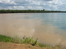
The Ivaí River (Portuguese, Rio Ivaí[4]) is a river of Paraná state in southern Brazil. It is a tributary of the Paraná River. Its official spelling is Ivaí, with variants including Ivahy and Ival.[5]
The river basin is ecologically very degraded, with fragile and vulnerable soil. It contains the 8,716 hectares (21,540 acres) Perobas Biological Reserve, a strictly protected conservation unit created in 2006.[6]
See also[]
Coordinates: 23°18′17″S 53°41′49″W / 23.30472°S 53.69694°W[7]

References[]
- ^ https://paperzz.com/doc/9029980/revista-brasileira-de-geomorfologia-river&ved=2ahUKEwjZkfHy5MvzAhVIsaQKHTHCB5Q4UBAWegQIGRAB&usg=AOvVaw2OHDNKuFAyjQQTjlBaXGEd.
{{cite web}}: Missing or empty|title=(help) - ^ https://paperzz.com/doc/9029980/revista-brasileira-de-geomorfologia-river&ved=2ahUKEwjZkfHy5MvzAhVIsaQKHTHCB5Q4UBAWegQIGRAB&usg=AOvVaw2OHDNKuFAyjQQTjlBaXGEd.
{{cite web}}: Missing or empty|title=(help) - ^ https://paperzz.com/doc/9029980/revista-brasileira-de-geomorfologia-river&ved=2ahUKEwjZkfHy5MvzAhVIsaQKHTHCB5Q4UBAWegQIGRAB&usg=AOvVaw2OHDNKuFAyjQQTjlBaXGEd.
{{cite web}}: Missing or empty|title=(help) - ^ Rio Ivaí at GEOnet Names Server
- ^ GEOnet Names Server
- ^ Reserva Biológica das Perobas (PDF) (in Portuguese), MMA, retrieved 2016-04-16
- ^ GNS coordinates adjusted using Google Maps, and GeoLocator
Categories:
- Rivers of Paraná (state)
- Tributaries of the Paraná River
- Paraná (state) river stubs