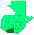
Iztapa
Iztapa
Ystapa[1] | |
|---|---|
 Iztapa Location in Guatemala | |
| Coordinates: 13°55′59″N 90°42′27″W / 13.93306°N 90.70750°WCoordinates: 13°55′59″N 90°42′27″W / 13.93306°N 90.70750°W | |
| Country | |
| Department | |
| Population | |
| • Total | 15,000 |
| Climate | Aw |

Iztapa (Spanish pronunciation: [isˈtapa]), or Puerto de Iztapa, is a municipality in the Escuintla department of Guatemala.
Located in the shores of Pacific Ocean and surrounded by and rivers, and also by the . Its population is about 15,000 people.[citation needed]
Etymology[]
As of 1850, the British were referring to the Iztapa as Yetapa.[1]
Archaeology[]
Fishtail points, the most common style of tool manufacturing in Mesoamerica, were discovered in Iztapa (c. 7700–7300 BCE).[citation needed] They are considered to be the remains of an archaic Iztapan culture.[citation needed]
Sports[]
Deportivo Iztapa football club play in the National League of Guatemalan football. Their home venue is the .
Iztapa is considered to be one of the best places in the world to catch Sailfish.[2]
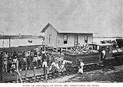
1897 port construction[]
In 1897, president José María Reina Barrios attempted to build an interoceanic railroad to offer it to international investors during the Central America Expo of that year. His ambitious plan included a terminal at Iztapa Port, which was being built to improve conditions at Puerto San José.[3] However, the international price collapse of both coffee and silver brought all work to standstill and the railroad could not be completed; instead of the economic boom that the president had hoped for, the Expo signifiedthe end of his regime. He was eventually murdered on 8 February 1898 after he tried to extend his presidential term until 1902.
Pictures from La Ilustración Guatemalteca[3]
Beginning of the Obero railroad.

Steamworks in Iztapa.

Michatoya river work

Michatoya river.[3]


Climate[]
Iztapa has a tropical savanna climate (Köppen: Aw).
| hideClimate data for Iztapa | |||||||||||||
|---|---|---|---|---|---|---|---|---|---|---|---|---|---|
| Month | Jan | Feb | Mar | Apr | May | Jun | Jul | Aug | Sep | Oct | Nov | Dec | Year |
| Average high °C (°F) | 32.1 (89.8) |
32.5 (90.5) |
33.1 (91.6) |
33.2 (91.8) |
32.7 (90.9) |
31.9 (89.4) |
32.1 (89.8) |
32.1 (89.8) |
31.4 (88.5) |
31.4 (88.5) |
32.0 (89.6) |
32.1 (89.8) |
32.2 (90.0) |
| Daily mean °C (°F) | 26.2 (79.2) |
26.6 (79.9) |
27.5 (81.5) |
28.2 (82.8) |
28.3 (82.9) |
27.9 (82.2) |
27.8 (82.0) |
27.6 (81.7) |
27.2 (81.0) |
26.8 (80.2) |
27.1 (80.8) |
26.6 (79.9) |
27.3 (81.2) |
| Average low °C (°F) | 20.3 (68.5) |
20.7 (69.3) |
22.0 (71.6) |
23.3 (73.9) |
24.0 (75.2) |
23.9 (75.0) |
23.5 (74.3) |
23.1 (73.6) |
23.1 (73.6) |
22.3 (72.1) |
22.2 (72.0) |
21.1 (70.0) |
22.5 (72.4) |
| Average precipitation mm (inches) | 0 (0) |
0 (0) |
6 (0.2) |
38 (1.5) |
136 (5.4) |
288 (11.3) |
241 (9.5) |
213 (8.4) |
320 (12.6) |
244 (9.6) |
31 (1.2) |
3 (0.1) |
1,520 (59.8) |
| Source: Climate-Data.org[4] | |||||||||||||
Geographic location[]
| show Places adjacent to Iztapa |
|---|
References[]
- ^ Jump up to: a b Baily, John (1850). Central America; Describing Each of the States of Guatemala, Honduras, Salvador, Nicaragua, and Costa Rica. London: Trelawney Saunders. p. 77.
- ^ Olander, Doug. "The World's Best Sailfish Spots". sportfishingmag.com. Sport Fishing Magazine. Retrieved 21 June 2019.
- ^ Jump up to: a b c Macías del Real, Antonio (15 July 1897). "Puerto de Iztapa". La Ilustración Guatemalteca (in Spanish). Guatemala: Síguere, Guirola & Cía. I (24). Retrieved 28 April 2015.
- ^ "Climate: Iztapa". Climate-Data.org. Retrieved 25 August 2015.
- ^ SEGEPLAN. "Municipios de Escuintla, Guatemala". Secretaría General de Planificación y Programación de la Presidencia de la República (in Spanish). Guatemala. Archived from the original on 14 July 2015. Retrieved 13 July 2015.
| show Authority control |
|---|
- Municipalities of the Escuintla Department