Jírova hill
| Jírova hora | |
|---|---|
 Jírova hora viewed from Hronov park | |
| Highest point | |
| Elevation | 485 m (1,591 ft) |
| Parent peak | |
| Coordinates | 50°29′13″N 16°10′32″E / 50.48694°N 16.17556°ECoordinates: 50°29′13″N 16°10′32″E / 50.48694°N 16.17556°E |
| Geography | |
 Jírova hora | |

Jírova mountain (Czech: Jírova hora) is a mountain situated between the villages of Zbečník, and , approximately 1 km northwest from the centre of the town Hronov, Czech Republic. The eastern slope of the hill is very steep. The whole hill is covered mainly by coniferous forest (mainly spruce trees) and meadows. A deciduous forest grows on the southern slope, falling to Zbečník. A part of the forest on the top of the hill and the north slope is formed by young coniferous trees. A very small stream flows from the northern slope, from Rokytník to Velký Dřevíč. On the top of the hill there is a radio communications transmitter. In the western direction from the top of hill, construction of an artillery fort of the Czechoslovak border fortification system was planned prior to World War II.
Photos[]

Jírova hora from the air.
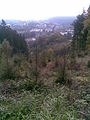
Panorama of Hronov and Zbečník viewed from the top.
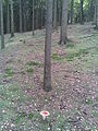
Forest on Jírova hora.

A small stream flowing from the northern slope.


Links[]
This Hradec Králové Region location article is a stub. You can help Wikipedia by . |
- Mountains and hills of the Czech Republic
- Hronov
- Hradec Králové Region geography stubs