Jagnjenica
Jagnjenica | |
|---|---|
Village | |
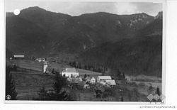
 Postcard of Jagnjenica | |
 Jagnjenica Location in Slovenia | |
| Coordinates: 46°4′1.37″N 15°7′30.91″E / 46.0670472°N 15.1252528°ECoordinates: 46°4′1.37″N 15°7′30.91″E / 46.0670472°N 15.1252528°E | |
| Country | |
| Traditional region | Lower Carniola |
| Statistical region | Lower Sava |
| Municipality | Radeče |
| Area | |
| • Total | 4.44 km2 (1.71 sq mi) |
| Elevation | 352.9 m (1,157.8 ft) |
| Population (2002) | |
| • Total | 326 |
| [1] | |
Jagnjenica (pronounced [ˈjaːɡnjɛnitsa]) is a settlement in the Municipality of Radeče in eastern Slovenia. The area is part of the historical region of Lower Carniola. The municipality is now included in the Lower Sava Statistical Region; until January 2014 it was part of the Savinja Statistical Region.[2]
The local church is dedicated to Saint Margaret (Slovene: sveta Marjeta) and belongs to the Parish of Svibno. It was built in 1900 on the site of an earlier church mentioned in written documents in the 16th century. Parts of the belfry include remnants of an 18th-century structure.[3]
References[]
- ^ Statistical Office of the Republic of Slovenia
- ^ Radeče municipal site
- ^ "EŠD 2413". Registry of Immovable Cultural Heritage (in Slovenian). Ministry of Culture of the Republic of Slovenia. Retrieved 20 May 2011.
External links[]
 Media related to Jagnjenica at Wikimedia Commons
- Jagnjenica at Geopedia
Categories:
- Populated places in the Municipality of Radeče
- Spodnjeposavska statistical region geography stubs

