Jamesville Colony, South Dakota
Jamesville Colony, South Dakota | |
|---|---|
 Jamesville Colony | |
| Coordinates: 43°6′9″N 97°28′54″W / 43.10250°N 97.48167°WCoordinates: 43°6′9″N 97°28′54″W / 43.10250°N 97.48167°W | |
| Country | United States |
| State | South Dakota |
| County | Yankton |
| Area | |
| • Total | 0.10 sq mi (0.27 km2) |
| • Land | 0.10 sq mi (0.27 km2) |
| • Water | 0.0 sq mi (0.0 km2) |
| Elevation | 1,200 ft (400 m) |
| Time zone | UTC-6 (Central (CST)) |
| • Summer (DST) | UTC-5 (CDT) |
| ZIP Code | 57067 (Utica) |
| Area code(s) | 605 |
| FIPS code | 46-32388 |
| GNIS feature ID | 2813067[2] |


Jamesville Colony is a census-designated place (CDP) and Hutterite colony[3] in Yankton County, South Dakota, United States. It was first listed as a CDP prior to the 2020 census.[2]
It is in the northwest part of the county, on the north side of the James River. It is 9 miles (14 km) north of Utica and 20 miles (32 km) north-northwest of Yankton, the county seat.
References[]
- ^ "2020 U.S. Gazetteer Files – South Dakota". United States Census Bureau. Retrieved September 21, 2021.
- ^ a b "Jamesville Colony Census Designated Place". Geographic Names Information System. United States Geological Survey.
- ^ Friesen, Bert (May 2021). "Jamesville Hutterite Colony (Utica, South Dakota, USA)". Global Anabaptist Mennonite Encyclopedia Online. Retrieved September 20, 2021.
Municipalities and communities of Yankton County, South Dakota, United States | ||
|---|---|---|
| Cities | 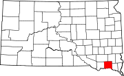 | |
| Towns | ||
| CDP | ||
| Footnotes | ‡This populated place also has portions in an adjacent county or counties | |
| ||
This South Dakota state location article is a stub. You can help Wikipedia by . |
Categories:
- Census-designated places in Yankton County, South Dakota
- Census-designated places in South Dakota
- Hutterite communities
- South Dakota geography stubs