Japan National Route 1
show This article may be expanded with text translated from the corresponding article in Japanese. (September 2012) Click [show] for important translation instructions. |
 | ||||
|---|---|---|---|---|
| 国道1号 | ||||
 | ||||
| Route information | ||||
| Length | 760.9 km[1] (472.8 mi) | |||
| Existed | 4 December 1952–present | |||
| Major junctions | ||||
| East end | ||||
| West end | ||||
| Highway system | ||||
| National highways of Japan Expressways of Japan
| ||||
National Route 1 (国道1号, Kokudō Ichi-gō) is a major highway on the island of Honshū in Japan. It connects Chūō, Tokyo in the Kantō region with the city of Osaka, Osaka Prefecture in the Kansai region, passing through the Chūbu region en route. It follows the old Tōkaidō westward from Tokyo to Kyoto, and the old Kyo Kaidō from there to Osaka. Between Tokyo and Aichi Prefecture it parallels the Tomei Expressway; from there to Mie Prefecture, the Higashi-Meihan Expressway, and from Shiga Prefecture to Osaka, the Meishin Expressway. It has a total length of 760.9 kilometers (472.8 mi). At its eastern terminus in Nihonbashi, Chūō, Tokyo, it meets National Routes 4, 6, 14, 15, 17, and 20. At its western terminus in Umeda, Kita-ku, Osaka, it links with Routes 2, 25, 26 and other highways.
National Route 1 links Tokyo to the important prefectural capitals of Yokohama (Kanagawa Prefecture), Shizuoka, Nagoya (Aichi Prefecture), Otsu (Shiga Prefecture), Kyoto, and Osaka.[2][3] It is the modern incarnation of the pre-modern Tōkaidō.
Route description[]

The main line of National Route 1 has a length of 638.4 kilometers (396.7 mi). When bypasses signed as National Route 1 are included, its total distance increases to 777.9 kilometers (483.4 mi).[4] Out of all of the national highways of Japan, it is the second longest land-based route after National Route 4,[5] though National Route 58 is the longest route when seabound routes are factored in.[6]
The highway's origin and eastern terminus lies at Nihonbashi in Tokyo's Chūō ward. At Nihonbashi it meets national routes 4, 6, 14, 15, 17, and 20. The highway passes through the cities of Kawasaki, Yokohama, Odawara, Numazu, Shizuoka, Hamamatsu, Nagoya, Yokkaichi, Ōtsu, and Kyoto. Its endpoint and western terminus lies in the Umeda district of Osaka's Kita ward. In Umeda, it has a junction with national routes 2, 26, 163, 165, 25, and 176.[4]
Overlapping sections[]
- In Chuo: Route 15
- From the origin to Chiyoda (Sakuradamon intersection): Route 20
- In Yokohama City, from Takashima-cho intersection to Hamamatsucho intersection: Route 16
- From Odawara City to Hakone Town (Miyanoshita intersection): Route 138
- From Hamamatsu City (Shinohara intersection) to Kosai City (Okurado IC): Route 42
History[]
National Route 1 was preceded by the Tōkaidō between Tokyo to Kyoto, and the old Kyo Kaidō from Kyoto to Osaka. The road's construction was order by the first shōgun of the Edo period, Tokugawa Ieyasu. It served to link the old capital of Japan, Kyoto, to Tokugawa's new capital, Edo. The Tōkaidō's post stations, known in Japanese as shukuba, were captured by the printmaker Utagawa Hiroshige in his ukiyo-e prints, The Fifty-three Stations of the Tōkaidō.[7]
In 1919, the first Road Act was passed, establishing a highway also called National Route 1 between Tokyo and the city of Shingū in Wakayama Prefecture partially along the current route.[8] On 4 December 1952 the route was designated by the Cabinet of Japan as Primary National Highway 1 between Tokyo and Osaka, establishing the highway almost entirely along its current routing. On 1 April 1965 the route was redesignated as General National Route 1.[9]
Junction list[]
All junctions listed are at-grade intersections unless noted otherwise.
| Prefecture | Location | km | mi | Destinations | Notes | |
|---|---|---|---|---|---|---|
| Tokyo | Chuo | Highway continues beyond eastern terminus as a concurrency of several national routes | ||||
| Nihonbashi Bridge (Inner Circular Route) | Eastern terminus of National Route 1; no direct access to Inner Circular Route | |||||
| Western end of National Route 15 concurrency | ||||||
| Chiyoda | – Kitaikebekuro, Shibuya | |||||
| – Kudanshita, Kokyomae | ||||||
| Western end of National Route 20 concurrency | ||||||
| Minato | – Tameike, Shinbashi | |||||
| – Roppongi | ||||||
| / | ||||||
| – Ebisu / – Tameike, Furukawabashi | ||||||
| – Meguro | ||||||
| Shinagawa | Togoshi entrance and exit; entrance to northbound expressway, exit from southbound expressway | |||||
| – Ohashi, Osaki | ||||||
| – Shinagawa | ||||||
| – | ||||||
| – Musashikoyoma | ||||||
| Ota | – Omori | |||||
| – Kamata, Shimo-Maruko Station | ||||||
| Kanagawa | Kawasaki | |||||
| (Tomei Expressway) – , Kawasaki Station | ||||||
| Yokohama | – Tsunashima, Tsurumi Station | |||||
| – | ||||||
| Interchange; eastbound exit and westbound entrance | ||||||
| – | ||||||
| Eastern end of National Route 16 concurrency | ||||||
| Western end of National Route 16 concurrency | ||||||
| – Kamakura | ||||||
| Kariba Interchange | ||||||
| – Sakuragicho, | ||||||
– Hino, Shin-Yokohama, Higashi-Totsuka Station | ||||||
– Seya | ||||||
| east – Kaminagaya | Eastern end of Kanagawa Prefecture Route 22 concurrency | |||||
| Western end of Kanagawa Prefecture Route 22 concurrency | ||||||
| Interchange; eastbound exit and westbound entrance | ||||||
| – Ofuna, | Interchange | |||||
| – Enoshima, Fujisawa | Interchange westbound; at-grade intersection eastbound | |||||
| Fujisawa | Interchange; no exits | |||||
| – Atsugi, | ||||||
| No access from Shin-Shōnan Bypass to westbound National Route 1; Fujisawa Interchange | ||||||
| Chigasaki | (Old Tōkaidō) east – Enoshima | Eastern end of Kanagawa Prefecture Route 44 concurrency | ||||
| west – Atsugi, Isehara | Western end of Kanagawa Prefecture Route 44 concurrency | |||||
| Access only to eastbound traffic and from westbound traffic; Chigasaki-nishi Interchange | ||||||
| Hiratsuka | ||||||
| north – Hadano, Isehara | ||||||
| Oiso | – Hadano | Eastern end of Kanagawa Prefecture Route 62 concurrency | ||||
– | Western end of Kanagawa Prefecture Route 62 concurrency | |||||
| Seishō Bypass | ||||||
| – to Odawara-Atsugi Road, Isehara | ||||||
| Ninomiya | to Odawara-Atsugi Road / to Tomei Expressway – Hadano / Seisho Bypass | |||||
| Odawara | – Matsuda, Nakai | |||||
| Seishō Bypass – , Yokohama | Interchange | |||||
| to Tomei Expressway – Matsuda / Seisho Bypass | ||||||
| / Seisho Bypass – Yokohama | ||||||
| Seishō Bypass – Odawara, Yokohama | Interchange | |||||
| Eastern end of unsigned National Route 138 concurrency | ||||||
| Seishō Bypass to Odawara-Atsugi Road / to Hakone Toll Road | Interchange | |||||
| Hakone | – Yugawara | |||||
| – | ||||||
| Western end of unsigned National Route 138 concurrency | ||||||
| – Gora | ||||||
| – , Owakudani | ||||||
| – Gotenba, | ||||||
| – Odawara, | ||||||
| to Hakone Toll Road – Yagawara | ||||||
| Interchange | ||||||
| – Atami / Ashinoko Skyline – | ||||||
| Shizuoka | Mishima | Shin-Tomei Expressway – to Tōmei Expressway | ||||
| – Central Mishima | ||||||
| Interchange | ||||||
| / – Mishima Station | ||||||
| Interchange | ||||||
| Numazu | ||||||
| – Numazu Station / | ||||||
| – Katahama Station | ||||||
| – Hara Station | ||||||
| Fuji | ||||||
| Interchange | ||||||
| – Fujinomiya | ||||||
| Shizuoka | Fujikawa | Interchange | ||||
| Kanbara | Interchange | |||||
| Interchange | ||||||
| to / to Tomei Expressway, Shin-Tomei Expressway / Miho, | ||||||
| – to Tomei Expressway, / to – Hamamatsu | ||||||
| – Miho, | ||||||
| – to | ||||||
| / | ||||||
| Interchange | ||||||
| (Utsunoya Pass) | ||||||
| Fujieda–Shizuoka border | ||||||
| Fujieda | Hirohata Interchange | |||||
| – Central Fujieda, Asahina | Interchange | |||||
| – Nishigata, Central Fujieda | Interchange | |||||
| – Central Fujieda, Setonoya | Interchange | |||||
| Shimada | Interchange | |||||
| Central Shimada | Interchange | |||||
| Kawanehon | Interchange | |||||
| Interchange | ||||||
| Interchange | ||||||
| Kakegawa | ||||||
| Interchange | ||||||
| Interchange | ||||||
| – Kurami, Central Kakegawa | Interchange | |||||
| – Mori, Central Kakegawa | Interchange | |||||
| Fukuroi | – Harakawa | |||||
| Interchange; eastbound exit and westbound entrance | ||||||
| – Aino Station, ECOPA Stadium | ||||||
| – Central Fukuroi | ||||||
| to Tomei Expressway – Mori, Central Fukuroi | Interchange | |||||
| Central Fukuroi | Interchange | |||||
| Iwata | Interchange; westbound exit and eastbound entrance | |||||
| – Tomei Expressway, Central Iwata, Fukude Fishing Port | Interchange | |||||
| – Fukude, Central Iwata | ||||||
| – Tenryu, Iwata Station | Interchange | |||||
| Interchange | ||||||
| – Central Iwata | Interchange | |||||
| Hamamatsu | – Hamakita | Interchange | ||||
| Interchange | ||||||
| – Maisaka Station | ||||||
| – Central Hamamatsu | ||||||
| Interchange; eastbound exit and westbound entrance | ||||||
| – Toyohashi, Hosoe | ||||||
| Kosai | – | |||||
| Interchange | ||||||
| Aichi | Toyohashi | |||||
| / | ||||||
| – Toyohashi Station / to Tomei Expressway – Toyokawa | ||||||
| Toyokawa | ||||||
| / | ||||||
| Okazaki | East end of National Route 473 concurrency | |||||
| West end of National Route 473 concurrency | ||||||
| Tomei Expressway – Okazaki | Interchange | |||||
| – Higashi-Okazaki Station | ||||||
| – Asuke / – Kota | ||||||
| – Central Anjo | ||||||
| – Nishio, Toyota | ||||||
| Anjo | – Central Anjo, Toyota | |||||
| – Toyota, Mikawa-Anjo Station | ||||||
| Chiryu | – Toyota, Takahama | Interchange | ||||
| Interchange | ||||||
| Toyoake | Interchange; westbound exit and eastbound entrance | |||||
| – Seto, Tojo | Interchange; southbound traffic access only; no access to Prefectural Route 57 south | |||||
| Nagoya | ||||||
| – Obu / Arimatsu Station | ||||||
| Airport Route – to National Route 41, Komaki, Tsuruma Park – National Highway Office | ||||||
| Interchange | ||||||
| – / | ||||||
| Interchange | ||||||
| Kanie | – Central Kanie | |||||
| south north | ||||||
| Interchange | ||||||
| south | Eastern end of Aichi Prefecture Route 462 concurrency | |||||
| Aisai | north – Eiwa Station | Western end of Aichi Prefecture Route 462 concurrency | ||||
| Yatomi | – Aisai | |||||
south | Eastern end of Aichi Prefecture Route 105 concurrency | |||||
| / north | Western end of Aichi Prefecture Route 105 concurrency | |||||
| Mie–Aichi border | (east span) | |||||
| Mie | Kuwana | |||||
| west | ||||||
| north – Kaizu | ||||||
| (west span) | ||||||
| south | ||||||
| east – Kuwana Post Office | ||||||
| Interchange | ||||||
| Asahi | ||||||
| Interchange | ||||||
| Kawagoe | – Tōin | |||||
| to Higashi-Meihan Expressway / – | ||||||
| Yokkaichi | ||||||
| / | ||||||
| – Sasagawa, Central Suzuka / | ||||||
| Suzuka | – , Central Suzuka | |||||
| to Higashi-Meihan Expressway – Central Suzuka | ||||||
| / Central Suzuka, Suzuka Circuit | Interchange | |||||
| Kameyama | ||||||
| To | Interchange | |||||
| Interchange | ||||||
| Interchange | ||||||
| Shiga–Mie border | ||||||
| Shiga | Koka | |||||
| / | ||||||
| Interchange | ||||||
| Interchange; eastbound exit and westbound entrance | ||||||
| / | ||||||
| Konan | ||||||
| / Prefectural Route 113 | ||||||
| / | ||||||
| Ritto–Konan border | Interchange | |||||
| Ritto | Eastern end of National Route 8 concurrency; interchange | |||||
| – Shigaraki | ||||||
| – / Shigaraki | ||||||
| – Moriyama | ||||||
| Kusatsu–Ritto border | ||||||
| Kusatsu | / | |||||
north (Kogan Road) | ||||||
| Interchange | ||||||
| Kyoto | Kyoto | west – Okazaki | Kyoto-higashi Interchange (E1 exit 32) | |||
| – Keage, | ||||||
| – Yamashinaekimaen, Uji, Nara | ||||||
| (Shibutani Road) | ||||||
| – Nara | ||||||
| – , | ||||||
| Western end of National Route 8 concurrency, eastern end of National Route 9 concurrency | ||||||
north – Kamigamo | Western end of National Route 9 concurrency | |||||
| – Shichijo-omiya | ||||||
| Kyoto-minami Interchange (E1 exit 33-1) | ||||||
| – | ||||||
| – / – Yodo | ||||||
| – Kongetsukyo, Nagokakyo | ||||||
| – Uji, Yodo | ||||||
| Yawata | – Uji, Yodo | |||||
| – Central Yawata | ||||||
| – Kyotanabe / Central Yawata | ||||||
| – Kyotanabe / – Central Yawata | ||||||
| – Nagao | ||||||
| – Kyotanabe, Central Yawata | ||||||
| Osaka | Hirakata | |||||
| – Nagao, Central Hirakata | ||||||
| – | ||||||
| Interchange eastbound; at-grade intersection westbound; east end of National Route 170 concurrency | ||||||
| Interchange westbound; at-grade intersection eastbound; west end of National Route 170 concurrency | ||||||
| Neyagawa | – / | |||||
| – Settsu | ||||||
| Moriguchi | ||||||
| – to , Sakai / – Neyagawa | ||||||
| Osaka | – / – Kadoma | |||||
| – Nara, Daito | ||||||
| – Tennoji Station / | ||||||
| Western terminus of National Route 1; highway continues west as National Route 2 | ||||||
1.000 mi = 1.609 km; 1.000 km = 0.621 mi
| ||||||
See also[]
- Gokishichidō, the ancient highways of Japan
Gallery[]

Nihonbashi, Tokyo terminus

Route 1 passes in front of the Imperial Palace in Tokyo.
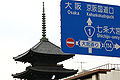
In Kyoto, Route 1 passes in front of Tō-ji.
Western terminus of Route 1 in Umeda

Route 1 heading through Shiba towards Tokyo Tower


References[]
- ^ "一般国道の路線別、都道府県別道路現況" [Road statistics by General National Highway route and prefecture] (PDF) (in Japanese). Ministry of Land, Infrastructure, Transport and Tourism. Retrieved 15 May 2020.
- ^ 一般国道1号 (in Japanese). Kinki Regional Development Bureau, Ministry of Land, Infrastructure, Transport and Tourism. Retrieved 26 November 2010.
- ^ 一般国道1号 (in Japanese). Kinki Regional Development Bureau, Ministry of Land, Infrastructure, Transport and Tourism. Retrieved 26 November 2010.
- ^ Jump up to: a b "一般国道の路線別、都道府県別道路現況" (PDF) (in Japanese). Ministry of Land, Infrastructure, Transport and Tourism. Retrieved 17 December 2020.
- ^ "起点から終点まで走ったことはある? "長距離国道"TOP3" [Have you ever driven from the origin to the end? Top 3 "Long-distance national highways"] (in Japanese). Toyo Tire Corporation. 26 July 2019. Retrieved 18 December 2020.
- ^ "身近な道路が実は"日本一"!?日本一の国道を走ろう!(その1)" [The familiar road is actually the best in Japan!? Let's drive on the best national road in Japan! (Part 1)]. On the Road (in Japanese). Toyo Tire Corporation. 29 October 2019. Retrieved 1 September 2020.
- ^ Leanne (8 May 2020). "Travelling Hiroshige's "The 53 Stations of Tokaido" Road". Voyagpon. Retrieved 18 December 2020.
- ^ "東海道の起源" [Origin of the Tōkaidō] (in Japanese). Shizuoka National Highway Office. 12 March 2020. Retrieved 12 December 2020.
- ^ "一般国道の路線を指定する政令" [Cabinet Order Designating General National Routes]. Act of 1965 (in Japanese). Cabinet of Japan. Retrieved 12 December 2020 – via Wikisource.
External links[]
 Media related to Category:Route 1 (Japan) at Wikimedia Commons
| show |
|---|
- National highways in Japan
- Roads in Aichi Prefecture
- Roads in Kanagawa Prefecture
- Roads in Kyoto Prefecture
- Roads in Mie Prefecture
- Roads in Osaka Prefecture
- Roads in Shiga Prefecture
- Roads in Shizuoka Prefecture
- Roads in Tokyo