Jiagedaqi District
This article needs additional citations for verification. (June 2021) |
Jiagedaqi
加格达奇(行政)区 | |
|---|---|
Administrative Zone | |
 | |
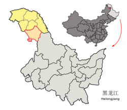 Location of the district (red outline) in Daxing'anling Prefecture (yellow fill) and Heilongjiang | |
 Jiagedaqi Location of the district seat relative to Heilongjiang | |
| Coordinates (Jiagedaqi District government): 50°24′31″N 124°08′23″E / 50.4087°N 124.1396°ECoordinates: 50°24′31″N 124°08′23″E / 50.4087°N 124.1396°E | |
| Country | People's Republic of China |
| Province | Heilongjiang |
| Prefecture | Daxing'anling |
| Area | |
| • Total | 1,587 km2 (613 sq mi) |
| Elevation | 472 m (1,549 ft) |
| Population | |
| • Total | 156,000 |
| • Density | 98/km2 (250/sq mi) |
| Time zone | UTC+8 (China Standard) |
| Postal code | 165000 |
| Area code(s) | 0457 |


Jiagedaqi District or Jagdaqi District (Oroqen: Jagdaqi, meaning "area with Pinus sylvestris var. mongolica Litvin"; simplified Chinese: 加格达奇区; traditional Chinese: 加格達奇區; pinyin: Jiāgédáqí Qū) is a district and the de facto seat of Daxing'anling Prefecture, Northeast China. Its physical location is in Inner Mongolia; however, it is de facto under the jurisdiction of Heilongjiang Province due to no suitable location of seat in Daxing'anling itself. The government of Inner Mongolia disputes this arrangement.
Administrative divisions[]
Jiagedaqi District is divided into the following administrative divisions:[1]
- (东山街道)
- (卫东街道)
- (红旗街道)
- (长虹街道)
- (曙光街道)
- (光明街道)
- (加北乡)
- (白桦乡)
Transport[]
- Jiagedaqi Airport
- China National Highway 111
- Nenjiang-Greater Khingan Forest (Nenlin) Railway
- Jiagedaqi railway station
References[]
- ^ www.stats.gov.cn http://www.stats.gov.cn/tjsj/tjbz/tjyqhdmhcxhfdm/2020/23/27/232761.html. Retrieved 2021-03-26.
{{cite web}}: Missing or empty|title=(help)
External links[]
- Official site of Jiagedaqi (in Chinese)

Jiagedaqi railway station in the evening
Heilongjiang topics | |
|---|---|
Harbin (capital) | |
| General |
|
| Geography | |
| Education | |
| Visitor attractions | |
| |
This Heilongjiang location article is a stub. You can help Wikipedia by . |
Categories:
- County level divisions of Heilongjiang
- Internal territorial disputes
- Heilongjiang geography stubs