Jim Woodruff Dam
| Jim Woodruff Dam | |
|---|---|
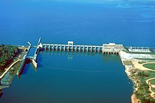 Aerial view of Jim Woodruff Dam in 1999 (by U.S. Army Corps of Engineers) | |
| Official name | Jim Woodruff Dam |
| Location | Gadsden and Jackson counties, Florida / Decatur County, Georgia, USA |
| Coordinates | 30°42′31″N 84°51′50″W / 30.70861°N 84.86389°WCoordinates: 30°42′31″N 84°51′50″W / 30.70861°N 84.86389°W |
| Construction began | about 1947 |
| Opening date | 1957 |
| Operator(s) | U.S. Army Corps of Engineers |
| Dam and spillways | |
| Impounds | Chattahoochee, and Flint Rivers |
| Reservoir | |
| Creates | Lake Seminole |
| Surface area | 58.6 square miles (152 km2) |


The dam, photographed from US90
Jim Woodruff Dam is a hydroelectric dam on the Apalachicola River, about 1,000 feet (300 m) south of that river's origin at the confluence of the Flint and Chattahoochee Rivers.
The dam impounds Lake Seminole on the common border of Florida and Georgia. The dam is named in honor of , a Georgia businessman who spearheaded the development of the Apalachicola-Chattahoochee-Flint Project.[1][2]
References[]
- ^ "The Jim Woodruff Dam Near Chattahoochee, Florida". www.anniemayhem.com. Retrieved 2020-03-20.
- ^ "Earth Snapshot • Jim Woodruff Lock and Dam". www.eosnap.com. Retrieved 2020-03-20.
This article about a dam or floodgate in the United States is a stub. You can help Wikipedia by . |
Categories:
- Dams in Florida
- Dams in Georgia (U.S. state)
- Buildings and structures in Decatur County, Georgia
- Buildings and structures in Gadsden County, Florida
- Buildings and structures in Jackson County, Florida
- United States Army Corps of Engineers dams
- Crossings of the Apalachicola River
- Dams completed in 1957
- 1957 establishments in Florida
- 1957 establishments in Georgia (U.S. state)
- United States dam stubs