Jimmy Smith Lake
| Jimmy Smith Lake | |
|---|---|
 Jimmy Smith Lake | |
 Jimmy Smith Lake | |
| Location | Custer County, Idaho |
| Coordinates | 44°10′07″N 114°24′06″W / 44.168560°N 114.401540°WCoordinates: 44°10′07″N 114°24′06″W / 44.168560°N 114.401540°W |
| Type | Ancient landslide |
| Primary inflows | |
| Primary outflows | Big Lake Creek to East Fork Salmon River |
| Basin countries | United States |
| Max. length | 895 m (2,936 ft) |
| Max. width | 355 m (1,165 ft) |
| Surface elevation | 1,930 m (6,330 ft) |


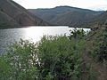
Jimmy Smith Lake is an alpine lake in Custer County, Idaho, United States, located at the northeast end of the White Cloud Mountains on the Bureau of Land Management land just east and downstream of the Sawtooth National Recreation Area border. The lake is accessed from trail 677, which is a 1-mile (1.6 km) improved ATV trail along , but there is no motorized vehicle access beyond the lake.[1]
Jimmy Smith Lake gives the appearance that it is a reservoir, however it was formed by an ancient landslide. The lake is stocked with rainbow trout, which makes it a popular year-round fishing destination for locals, and a dispersed camping area and vault toilet are located at the trailhead.[2][3][4]

Jimmy Smith Lake landslide
Jimmy Smith Lake


See also[]
| Wikimedia Commons has media related to Jimmy Smith Lake. |
References[]
- ^ Sawtooth National Forest (Map) (2012 ed.). 1:126,720. Sawtooth National Forest, U.S. Forest Service.
- ^ "Salmon River Fisheries" (PDF). Idaho Department of Fish and Game. Archived from the original (PDF) on August 11, 2015. Retrieved August 11, 2015. Cite journal requires
|journal=(help) - ^ "Jimmy Smith Lake Trailhead". Bureau of Land Management. Archived from the original on August 11, 2015. Retrieved August 11, 2015.
- ^ "Jimmy Smith Lake - East Fork Salmon River". Boulder-White Clouds Council. May 13, 2006. Archived from the original on August 11, 2015. Retrieved August 11, 2015.
| Authority control |
|
|---|
This Geographical stub article in Custer County, Idaho is a stub. You can help Wikipedia by . |
- Lakes of Idaho
- Lakes of Custer County, Idaho
- Sawtooth National Forest
- Landslide-dammed lakes
- Geography of Custer County, Idaho
- Custer County, Idaho geography stubs