Joly, Ontario
Joly | |
|---|---|
Township (single-tier) | |
| Township of Joly | |
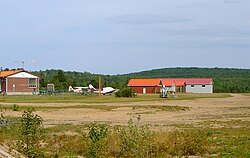 South River-Sundridge District Airport | |
 Joly | |
| Coordinates: 45°47′N 79°15′W / 45.783°N 79.250°WCoordinates: 45°47′N 79°15′W / 45.783°N 79.250°W | |
| Country | Canada |
| Province | Ontario |
| District | Parry Sound |
| Government | |
| • Type | Township |
| • Mayor | Tim Bryson |
| • Federal riding | Parry Sound—Muskoka |
| • Prov. riding | Parry Sound—Muskoka |
| Area | |
| • Land | 194.73 km2 (75.19 sq mi) |
| Population (2016)[2] | |
| • Total | 304 |
| • Density | 1.6/km2 (4/sq mi) |
| Time zone | UTC-5 (EST) |
| • Summer (DST) | UTC-4 (EDT) |
| Postal Code | P0A |
| Area code(s) | 705, 249 |

Joly is a township in the Almaguin Highlands region of Parry Sound District of the Canadian province of Ontario.
The township has no named communities within its boundaries; all addresses in the township are rural routes assigned to the adjacent communities of South River, Sundridge, Hartfell or Pevensey. The South River-Sundridge District Airport is in Joly.
Demographics[]
| Year | Pop. | ±% |
|---|---|---|
| 1991 | 248 | — |
| 1996 | 311 | +25.4% |
| 2001 | 290 | −6.8% |
| 2006 | 280 | −3.4% |
| 2011 | 284 | +1.4% |
| 2016 | 304 | +7.0% |
| [3][1][2] | ||
Private dwellings occupied by usual residents: 135 (total dwellings: 164)
Mother tongue:[2]
- English as first language: 90.2%
- French as first language: 1.6%
- Other as first language: 8.2%
See also[]
References[]
- ^ a b Statistics Canada 2011 Census - Joly Census Profile
- ^ a b c "Census Profile, 2016 Census: Joly, Township". Statistics Canada. Retrieved June 28, 2019.
- ^ Statistics Canada: 1996, 2001, 2006
External links[]
Places adjacent to Joly, Ontario | |
|---|---|
| Towns |  | |
|---|---|---|
| Townships | ||
| Villages | ||
| First Nations | ||
| Indian reserves | ||
| Local services boards | ||
| Unorganized areas | ||
| ||
This Northern Ontario geographical article is a stub. You can help Wikipedia by . |
Categories:
- Municipalities in Parry Sound District
- Single-tier municipalities in Ontario
- Township municipalities in Ontario
- Northern Ontario geography stubs