Jos Plateau
| Jos Plateau Jos Plateau forest-grassland mosaic | |
|---|---|
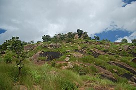 Hillside near Jos | |
 location of the Jos Plateau | |
| Ecology | |
| Realm | Afrotropical |
| Biome | montane grasslands and shrublands |
| Borders | Guinean forest-savanna mosaic and West Sudanian savanna |
| Geography | |
| Area | 13,281 km2 (5,128 sq mi) |
| Country | Nigeria |
| States | Plateau, Bauchi, and Kaduna |
| Conservation | |
| Conservation status | Critical/endangered[1] |
| Protected | 1,199 km² (9%)[2] |
The Jos Plateau is a plateau located near the centre of Nigeria. The plateau has given its name to the Plateau State in which it is found and is named for the state's capital, Jos. The plateau is home to people of diverse cultures and languages. The plateau's montane grasslands, savannas, and forests are home to communities of plants and animals distinct from those of the surrounding lowlands and constitute the Jos Plateau forest-savanna mosaic ecoregion.
Geography[]
It covers 8600 km² and is bounded by 300–600 m escarpments around much of its boundary. With an average altitude of 1,280 m, it is the largest area over 1,000 m in Nigeria, with a high point of 1,829 m, in the Shere Hills. Several rivers have their sources on the plateau. The Kaduna River drains the western slopes, flowing southwest to join the Niger. The Gongola River drains eastwards to join the Benue. The Hadejia and Yobe rivers flow northeast into Lake Chad.
Geology[]
The Jos Plateau is dominated by three rock types. The older granites date to the late Cambrian and Ordovician. The younger granites are emplacements dating to the Jurassic and form part of a series that includes the Aïr Massif in the central Sahara. There are also many volcanoes and sheets of basalt extruded since the Pliocene.[3] The younger granites contain tin which was mined since the beginning of the 20th century, during and after the colonial period.[4]
Climate[]
The climate on the plateau is tropical but cooler than the surrounding lowlands. Average temperatures range from 15.5 °C to 18.5 °C in the coolest months to 27.5 °C to 30.5 °C during the hottest months. Rainfall ranges from 2,000 mm per year in the southwest to 1,500 mm or less in the drier northeast. Rainfall for the town of Jos averages 1,411 mm per year. Rainfall is highly seasonal, falling mostly between June and September with July and August the wettest months. Moisture-bearing winds come from the south and west, and rainfall is higher on the windward south- and west-facing slopes.[1]
Flora and fauna[]
The natural vegetation of the region was likely a mosaic of savanna, open woodland, and forest. Human activities have reduced the plateau's tree cover, and most of the plateau is now covered by open grassland. Small areas of woodland and forest remain on steep and inaccessible sites, including the southern and western escarpments, along rivers, and at the base of rock outcrops.[1] The plateau is home to West Africa’s only population of klipspringer (Oreotragus oreotragus), as well as several endemic birds and mammals, including the Nigerian mole-rat (Cryptomys foxi), Fox's shaggy rat (Dasymys foxi), rock firefinch (Lagonosticta sanguinodorsalis), and Jos Plateau indigobird (Vidua maryae).[1]
People[]
The Jos Plateau lies in the Nigerian Middle Belt, and even in this region known for cultural diversity, it is unusually diverse. Barbour et al. (1982:49) show over 60 ethno-linguistic groups on the plateau[5] Most of the plateau's languages are in the Chadic family,[6] which is part of the Afro-Asiatic family. Two of the Plateau's largest ethnic groups are the Berom, in the northern Plateau, and the Ngas in the southeast. Smaller groups include the Mwaghavul, Pyem, Ron, Afizere, Anaguta, Aten, Irigwe, Chokfem, Kofyar, Kulere, Miship, Mupun and Montol.
The Jos Plateau is home to the ancient Nok culture, known for its remarkable terracotta artwork. After the British colonization of Nigeria, Jos Plateau became a mining region and one of the most important tourist destinations in Nigeria, but touristic activity was impeded in early 21st century by a new conflict between Christians and Muslims as a result of tribal and political differences between the inhabitants of the Jos Plateau.
Threats and conservation[]
The Jos plateau is a heavily-populated area with loss of native savanna and woodland to farmland conversion and firewood collection; remaining native fauna is predominately limited to small areas in the more remote areas and river embankments. There is currently no conservation program for this ecoregion. Due to tin mining activity some 320 km² of agricultural land has been disturbed.[4] The situation has been improved since by local farmers due to usage of traditional as well as modern fertilisation methods which combined includes manure, urban waste ash and inorganic fertilizers.[4] Approximately 1,199 km², or 9%, of the ecoregion is in protected areas.[2] Protected areas include the Jarawa Hill, Jere, Rafin Bawa, Panshanu, Guram River, Assob Bachit, Kurra Jekko, and Abak River forest reserves.[7]
External links[]
| Wikimedia Commons has media related to Jos Plateau. |
- "Jos Plateau". Global Volcanism Program. Smithsonian Institution. Retrieved 2021-06-24.
- "Jos Plateau forest-grassland mosaic". Terrestrial Ecoregions. World Wildlife Fund.
- Hiking on the plateau
References[]
- ^ Jump up to: a b c d "Jos Plateau forest-grassland mosaic". Terrestrial Ecoregions. World Wildlife Fund.
- ^ Jump up to: a b Dinerstein, Eric; Olson, David; et al. (June 2017). "An Ecoregion-Based Approach to Protecting Half the Terrestrial Realm". BioScience. 67 (6): 534–545. doi:10.1093/biosci/bix014. PMC 5451287. PMID 28608869.CS1 maint: date and year (link) Supplemental material 2 table S1b.
- ^ Morgan, W.T.W. (1983) Nigeria. Longman, London.
- ^ Jump up to: a b c Pasquini, MW; Alexander, MJ (2005). "Soil fertility management strategies on the Jos Plateau: the need for integrating 'empirical' and 'scientific' knowledge in agricultural development". Geographical Journal. 171 (2): 112–124. doi:10.1111/j.1475-4959.2005.00154.x.
- ^ State., Better Life Programme (Nigeria). Plateau (c. 1992). Traditional dishes, snacks, drinks & herbs from Plateau State. [Better Life Programme, Plateau State]. OCLC 29704741.
- ^ Isichei, Elizabeth (1982). "Introduction". In Studies in the History of Plateau State, Nigeria, ed. by Elizabeth Isichei, pp 1–57. Macmillan, London.
- ^ UNEP-WCMC (2020). Protected Area Profile for Nigeria from the World Database of Protected Areas, September 2020. Available at: www.protectedplanet.net
- Barbour, K.M., et al., editors. 1982 Nigeria in Maps. Hodder and Stoughton, London.
- "Jos Plateau". Encyclopædia Britannica.
| hide Authority control | |
|---|---|
| General |
|
| National libraries | |

- Afromontane ecoregions
- Afrotropical ecoregions
- Ecoregions of Nigeria
- Montane grasslands and shrublands
- Plateaus of Nigeria
- Plateau State
- Volcanoes of Nigeria