Jungnang District
Jungnang
중랑구 | |
|---|---|
| 중랑구 · 中浪區 | |
 Jungang Line and Gyeongchun Line | |
 Flag | |
 Location of Jungnang-gu in Seoul | |
| Country | South Korea |
| Region | Sudogwon |
| Special City | Seoul |
| Administrative dong | 20 |
| Government | |
| • Mayor | Ryu Gyeong-gi |
| Area | |
| • Total | 18.50 km2 (7.14 sq mi) |
| Population (2010[1]) | |
| • Total | 403,105 |
| • Density | 22,000/km2 (56,000/sq mi) |
| Time zone | UTC+9 (Korea Standard Time) |
| Postal code | 02000~02399 |
| Area code | 02-400~ |
| Website | Jungnang-gu official website |
Jungnang District (Jungnang-gu) is one of the 25 gu, or districts, of Seoul, South Korea. It is located on the north side of the Han River.[2]
The mayor of this district is Ryu Gyeong-gi (류경기) since his election in June 2018.
Administrative divisions[]
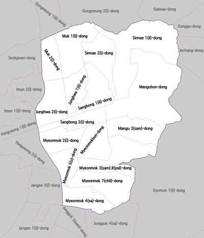
Administrative divisions
- Junghwa-dong (중화동 中和洞) 1, 2
- Mangu-dong (망우동 忘憂洞) 3, Bondong (1 and 2 are combined in Jan. of 2008)
- Muk-dong (묵동 墨洞) 1, 2
- Myeonmok-dong (면목동 面牧洞) 2, 3, 4, 5, 7, Bondong (1 and 6 are combined in Jan. of 2008)
- Sangbong-dong (상봉동 上鳳洞) 1, 2
- Sinnae-dong (신내동 新內洞) 1, 2
Transportation[]
Railroad[]
- Jungang Line
- (Dongdaemun-gu) ← Jungnang — Sangbong — Mangu — Yangwon → (Guri)—
- (Nowon-gu) ← Bonghwasan
- (Nowon-gu) ← Meokgol — Junghwa — Sangbong — Myeonmok — Sagajeong — Yongmasan → (Gwangjin-gu)
Sister cities[]
 Cheongwen, China
See also[]
References[]
- ^ Korean Statistical Information Service (Korean) > Population and Household > Census Result (2010) > Population by Administrative district, Sex and Age / Alien by Administrative district and Sex Archived 2013-08-26 at the Wayback Machine, Retrieved 2010-06-02.
- ^ "중랑구 (Jungnang-gu 中浪區)" (in Korean). Doosan Encyclopedia. Retrieved 2008-04-17.[permanent dead link]
External links[]
| Wikimedia Commons has media related to Jungnang-gu, Seoul. |
| hide | ||||||
|---|---|---|---|---|---|---|
| Districts |
|  | ||||
| Neighbourhoods | ||||||
| Authority control |
|
|---|
Coordinates: 37°36′23″N 127°05��33″E / 37.6064°N 127.0926°E

Categories:
- Jungnang District