Jutulhogget (Antarctica)
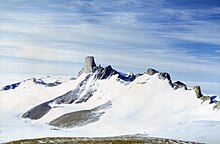
View of the northeastern part of the Jutulsessen Mountain
Jutulhogget, also known as Jutulhogget Peak, (72°2′S 2°51′E / 72.033°S 2.850°ECoordinates: 72°2′S 2°51′E / 72.033°S 2.850°E) is a high peak in the eastern ridge of Jutulsessen Mountain, in the Gjelsvik Mountains of Queen Maud Land. It was photographed from the air by the Third German Antarctic Expedition (1938–39). It was mapped by Norwegian cartographers from surveys and air photos by the Norwegian–British–Swedish Antarctic Expedition (1958–59) and named after Jutulhogget, Norway's largest canyon.[1][2]
 WikiMiniAtlas
References[]
- ^ "Jutulhogget". Norwegian Polar Institute. Retrieved 29 September 2012.
- ^ "Jutulhogget Peak". Geographic Names Information System. United States Geological Survey. Retrieved 10 April 2013.
![]() This article incorporates public domain material from the United States Geological Survey document: "Jutulhogget Peak". (content from the Geographic Names Information System)
This article incorporates public domain material from the United States Geological Survey document: "Jutulhogget Peak". (content from the Geographic Names Information System)
Categories:
- Mountains of Queen Maud Land
- Princess Martha Coast
- Princess Martha Coast geography stubs