Königswartha
Königswartha
Rakecy | |
|---|---|
 | |
 Coat of arms | |
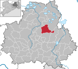
show Location of Königswartha within Bautzen district | |
 Königswartha | |
| Coordinates: 51°19′N 14°20′E / 51.317°N 14.333°ECoordinates: 51°19′N 14°20′E / 51.317°N 14.333°E | |
| Country | Germany |
| State | Saxony |
| District | Bautzen |
| Government | |
| • Mayor (2015–22) | Swen Nowotny[1] (CDU) |
| Area | |
| • Total | 47.04 km2 (18.16 sq mi) |
| Elevation | 141 m (463 ft) |
| Population (2020-12-31)[2] | |
| • Total | 3,394 |
| • Density | 72/km2 (190/sq mi) |
| Time zone | UTC+01:00 (CET) |
| • Summer (DST) | UTC+02:00 (CEST) |
| Postal codes | 02699 |
| Dialling codes | 035931 |
| Vehicle registration | BZ, BIW, HY, KM |
| Website | www.koenigswartha.net |


Königswartha, in Sorbian Rakecy, is a municipality in the east of Saxony, Germany. It belongs to the district of Bautzen and lies 20 km north of the eponymous city.
The municipality is part of the recognized Sorbian settlement area in Saxony. Upper Sorbian has an official status next to German, all villages bear names in both languages.
"Rakecy" means "men of the crab" (rak being Sorbian for "crab"). The village was mentioned the first time in 1350.
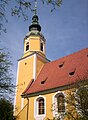
Church in Königswartha

Town hall
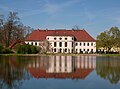
Castle of Königswartha

Old house in Königswartha
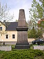
War memorial

Rest home


Geography[]
The municipality is situated in the Upper Lusatian flatland. The village stretches along the river Schwarzwasser.
Villages[]
Several villages belong to the municipality:
- Caminau (Kamjenej)
- Commerau (Komorow)
- Entenschenke (Kača Korčma)
- Eutrich (Jitk)
- Johnsdorf (Jeńšecy)
- Königswartha (Rakecy)
- Neudorf (Nowa Wjes)
- Niesendorf (Niža Wjes)
- Oppitz (Psowje)
- Truppen (Trupin)
- Wartha (Stróža)
References[]
- ^ Bürgermeisterwahlen 2015, Freistaat Sachsen, accessed 12 July 2021.
- ^ "Bevölkerung des Freistaates Sachsen nach Gemeinden am 31. Dezember 2020". Statistisches Landesamt des Freistaates Sachsen (in German). June 2021.
| show Towns and municipalities in Bautzen (district) |
|---|
| show Authority control |
|---|
This Bautzen location article is a stub. You can help Wikipedia by . |
- Municipalities in Saxony
- Bautzen (district)
- Localities in Upper Lusatia
- Kingdom of Saxony
- Bezirk Dresden
- Bautzen district geography stubs