Kaliningrad Oblast
This article needs additional citations for verification. (August 2021) |
Kaliningrad Oblast | |
|---|---|
| Калининградская область | |
 Coat of arms | |
| Anthem: none[1] | |
 | |
| Coordinates: 54°48′N 21°25′E / 54.800°N 21.417°ECoordinates: 54°48′N 21°25′E / 54.800°N 21.417°E | |
| Country | Russia |
| Federal district | Northwestern[2] |
| Economic region | Kaliningrad[3] |
| Administrative center | Kaliningrad |
| Government | |
| • Body | Kaliningrad Oblast Duma[5] |
| • Governor[6] | Anton Alikhanov |
| Area | |
| • Total | 15,100 km2 (5,800 sq mi) |
| Area rank | 76th |
| Population (2010 Census)[8] | |
| • Total | 941,873 |
| • Estimate (2018)[9] | 994,599 (+5.6%) |
| • Rank | 56th |
| • Density | 62/km2 (160/sq mi) |
| • Urban | 77.6% |
| • Rural | 22.4% |
| Time zone | UTC+2 (MSK–1 |
| ISO 3166 code | RU-KGD |
| License plates | 39, 91 |
| OKTMO ID | 27000000 |
| Official languages | Russian[11] |
| Website | http://www.gov39.ru |


Kaliningrad Oblast (Russian: Калинингра́дская о́бласть, romanized: Kaliningradskaya oblast') is the westernmost federal subject of Russia. It is a semi-exclave, and is situated on the Baltic coast. The oblast's largest city and administrative centre is the city of Kaliningrad, formerly known as Königsberg. The oblast's port city of Baltiysk is Russia's only port on the Baltic Sea that remains ice-free in winter. The oblast had a population of roughly 1 million in the Russian Census of 2010.[8]
The oblast is bordered by Poland to the south, Lithuania to the north and east, and the Baltic Sea to the west. It is impossible to travel overland between the oblast and Russia without passing through at least two other countries. The territory was formerly the northern part of the Prussian province of East Prussia, the southern part of which is today part of the Warmian-Masurian Voivodeship in Poland. With the defeat of Nazi Germany in World War II, the territory was annexed as part of the Russian SFSR by the Soviet Union. Following the post-war migration and flight and expulsion of Germans, the territory was populated with mostly Russians. As of the 2010 census, few Germans remain.[12]
History[]
Middle Ages[]
This section does not cite any sources. (August 2021) |

Before and during the Middle Ages, the territory of what is now the Kaliningrad Oblast was inhabited by the Old Prussians (Sambians) in the western part and by Lithuanians in the eastern part. The tribes were divided by the rivers Pregolya and Łyna. The Teutonic Order conquered the region and established a monastic state. On the foundations of a destroyed Prussian settlement known as Tvanksta, the Order founded the city of Königsberg (modern Kaliningrad). Germans resettled the territory and assimilated the indigenous Old Prussians. The Lithuanian-inhabited areas became known as Lithuania Minor. The old Baltic languages became extinct around the 17th century, their speakers having been assimilated and Germanised.
Pre-Modern Period[]
This section does not cite any sources. (August 2021) |
  History of Brandenburg and Prussia | ||||
| Northern March 965–983 |
Old Prussians pre-13th century | |||
| Lutician federation 983 – 12th century | ||||
| Margraviate of Brandenburg 1157–1618 (1806) (HRE) (Bohemia 1373–1415) |
Teutonic Order 1224–1525 (Polish fief 1466–1525) | |||
| Duchy of Prussia 1525–1618 (1701) (Polish fief 1525–1657) |
Royal (Polish) Prussia (Poland) 1454/1466 – 1772 | |||
| Brandenburg-Prussia 1618–1701 | ||||
| Kingdom in Prussia 1701–1772 | ||||
| Kingdom of Prussia 1772–1918 | ||||
| Free State of Prussia (Germany) 1918–1947 |
Klaipėda Region (Lithuania) 1920–1939 / 1945–present |
Recovered Territories (Poland) 1918/1945–present | ||
| Brandenburg (Germany) 1947–1952 / 1990–present |
Kaliningrad Oblast (Russia) 1945–present | |||
In 1525, Grand Master Albert of Brandenburg secularized the Teutonic Order's Prussian branch and established himself as ruler of the Duchy of Prussia. The duchy was nominally a fief of the Polish crown. It later merged with the Margraviate of Brandenburg. Königsberg was the duchy's capital from 1525 until 1701. As Prussia's centre moved westward, the capital's position became too peripheral and Berlin became the new Prussian capital. During the Seven Years' War it was occupied by the Russian Empire. The region was reorganized into the Province of East Prussia within the Kingdom of Prussia in 1773. The territory of the Kaliningrad Oblast lies in the northern part of East Prussia.
Modern period[]
First Russian annexation (1758–62)[]
In the context of the Seven Year War, Russia allied with Austria and France against Prussia and England. After crushing victories against Prussia, Russia occupied all of East Prussia and officially annexed it in 1758.[13] The inhabitants, including Kant, swore an oath to Empress Elizabeth.[14] But after her death, the new Russian Tsar, Peter III, Duke of Holstein-Gottorp, decided to return it to Prussia in 1762 to establish an alliance with the latter as Peter III aimed at regaining his duchy, then occupied by Denmark.[15]
Napoleonic occupation[]
After the defeats of Jena–Auerstedt, the Kingdom of Prussia was invaded and Berlin was occupied by the French. The Court of Prussia fled to Königsberg, asking Russian help. Russia interfered and this led to the bloody battle of Eylau and battle of Friedland in 1807. The French won and signed the Treaties of Tilsit.[16]
Historical ethnic and religious structure[]
In 1817, East Prussia had 796,204 Protestants, 120,123 Roman Catholics, 2,389 Jews, and 864 Mennonites.[17]
In 1824, shortly before its merger with West Prussia, the population of East Prussia was 1,080,000 people.[18] According to Karl Andree, Germans were slightly more than half of the people, while 280,000 (~26%) were ethnically Polish and 200,000 (~19%) were ethnically Lithuanian.[19] As of 1819 there were also 20,000 strong ethnic Curonian and Latvian minorities as well as 2,400 Jews, according to Georg Hassel.[20] Similar numbers are given by August von Haxthausen in his 1839 book, with a breakdown by county.[21] However, the majority of East Prussian Polish and Lithuanian inhabitants were Lutherans, not Roman Catholics like their ethnic kinsmen across the border in the Russian Empire. Only in Southern Warmia (German: Ermland) Catholic Poles – so called Warmiacy (not to be confused with predominantly Protestant Masurians) – comprised the majority of population, numbering 26,067 people (~81%) in county Allenstein (Polish: Olsztyn) in 1837.[21] Another minority in 19th-century East Prussia, were ethnically Russian Old Believers, also known as Philipponnen – their main town was Eckersdorf (Wojnowo).[22][23][24]
German culture and Germanization[]
This section does not cite any sources. (August 2021) |
East Prussia was an important centre of German culture. Many important figures, such as Immanuel Kant and E. T. A. Hoffmann, came from this region. Despite being heavily damaged during World War II and thereafter, the oblast's cities still contain examples of German architecture. The Jugendstil style showcases the rich German history and cultural importance of the area.
By the early 20th century, Lithuanians formed a majority only in rural parts of north-eastern East Prussia (Memelland and Lithuania Minor). The same was true of the Latvian-speaking Kursenieki who had settled the coast of East Prussia between Gdańsk and Klaipėda. The rest of the area, except the Polish Masurians in Mazury (southern Prussia), was overwhelmingly German-speaking.
The Memel Territory (Klaipėda region), formerly part of north-eastern East Prussia as well as Lithuania Minor, was annexed by Lithuania in 1923. In 1938, Nazi Germany radically renamed about a third of the place names of this area, replacing Old Prussian and Lithuanian names with newly invented German names.

Historical Lithuania Minor comprises a sizeable part of Prussian region that is now the Kaliningrad Oblast.

The Curonian spit in 1649, inhabited by the Kursenieki
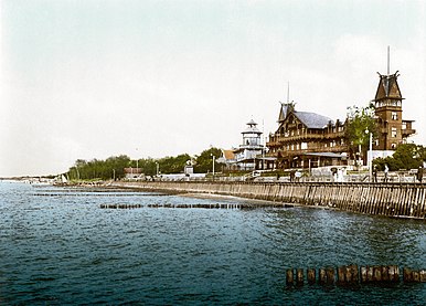
The East Prussian resort town of Cranz (Zelenogradsk today) as it looked ca. 1900. It was a destination for German artists and intelligentsia.


World War I[]
In September 1914, after hostilities began between Germany, France and Russia, the Reich was about to seize Paris, the French urged Russia to attack East Prussia. Nicholas II launched a major attack, resulting in a Russian victory in the Battle of Gumbinnen. The Russian army arrived at Königsberg's outskirts but did not take it and settled at Insterburg. This Russian victory and East Prussia's occupation by Russia saved Paris by forcing the Germans to send many troops to their East provinces.[25] Later Hindenburg and Lüdendorff pulled Russia back at the battle of Tannenberg, hence liberating East Prussia from Russian troops. Yet Russian troops remained in the easternmost part of the region till early 1915.[26]
Takeover by the Soviet Union[]
On August 29, 1944, Soviet troops reached the border of East Prussia. By January 1945, they had taken all of East Prussia except for the area around Königsberg. Many inhabitants fled west at this time. During the war's last days, over two million people fled before the Red Army and were evacuated by sea. Under the Potsdam Agreement's terms, the city became part of the Soviet Union pending the final determination of territorial questions at a peace settlement. This final determination took place on 12 September 1990 with the signing of the Treaty on the Final Settlement with Respect to Germany. The excerpt pertaining to the partition of East Prussia including the area surrounding Königsberg is as follows (note that Königsberg is spelt "Koenigsberg" in the original document):
VI. CITY OF KOENIGSBERG AND THE ADJACENT AREA
The Conference examined a proposal by the Soviet Government that pending the final determination of territorial questions at the peace settlement, the section of the western frontier of the Union of Soviet Socialist Republics which is adjacent to the Baltic Sea should pass from a point on the eastern shore of the Bay of Danzig to the east, north of Braunsberg – Goldep, to the meeting point of the frontiers of Lithuania, the Polish Republic and East Prussia.The Conference has agreed in principle to the proposal of the Soviet Government concerning the ultimate transfer to the Soviet Union of the city of Koenigsberg and the area adjacent to it as described above, subject to expert examination of the actual frontier.
The President of the United States and the British Prime Minister have declared that they will support the proposal of the Conference at the forthcoming peace settlement.[27]
Königsberg was renamed Kaliningrad in 1946 in memory of Chairman of the Presidium of the Supreme Soviet of the USSR Mikhail Kalinin. The remaining German population was forcibly expelled between 1947 and 1948. The annexed territory was populated with Soviet citizens, mostly ethnic Russians but to a lesser extent also Ukrainians and Belarusians.[28]
The German language was replaced with the Russian language. In 1950, there were 1,165,000 inhabitants, which was only half the number of the pre-war population.
Cold War period[]
The city was rebuilt during the Cold War.[citation needed] The territory became strategically important as the Soviet Baltic Fleet's headquarters, as the port is ice-free in winter unlike Saint Petersburg (then Leningrad). Hence, the city was closed to foreign visitors.
The reconstruction of the Oblast', threatened by hunger in the immediate post-war years, was carried out through an ambitious and efficient policy of oceanic fishing[29] with the creation of one of the main fishing harbours of the USSR in Kaliningrad city. Fishing not only fed the regional economy but also was a basis for social and scientific development, in particular oceanography.[30] The region remained ocean-oriented until 1990.[31]
In 1957, an agreement was signed and later came into force which delimited the border between Poland and the Soviet Union.[32][33]
The region was added as a semi-exclave to the Russian SFSR; since 1946 it has been known as the Kaliningrad Oblast. According to some historians, Stalin created it as an oblast separate from the Lithuanian SSR because it further separated the Baltic states from the West.[34] Others think that the reason was that the region was far too strategic for the USSR to leave it in the hands of another SSR than the Russian one.[35] The names of the cities, towns, rivers and other geographical features were changed to Russian names.
The area was administered by the planning committee of the Lithuanian SSR, although it had its own Communist Party committee.[citation needed] However, the leadership of the Lithuanian SSR (especially Antanas Sniečkus) refused to annex the territory.[28] In 2010, the German magazine Der Spiegel published a report claiming that Kaliningrad had been offered to Germany in 1990 (against payment), but this was denied by Mikhail Gorbachev.[36]
Today[]


Kaliningrad's isolation was exacerbated by the collapse of the Soviet Union in 1991 when Lithuania became an independent country and even more when both Poland and Lithuania became members of NATO and subsequently the European Union in 2004. Since the dissolution of the Soviet Union and the independence of the Baltic states, Kaliningrad Oblast has been separated from the rest of Russia by other countries instead of by other Soviet republics. Neighboring nations imposed strict border controls when they joined the European Union. All military and civilian land links between the region and the rest of Russia have to pass through members of NATO and the EU. Russian proposals for visa-free travel between the EU and Kaliningrad have so far been rejected by the EU. Travel arrangements, based on the Facilitated Transit Document (FTD) and Facilitated Rail Transit Document (FRTD)[37][38] have been made.[37][38] On January 12, 1996, Kaliningrad Oblast, alongside Sverdlovsk, became the first oblasts of Russia to sign a power-sharing treaty with the federal government, granting it autonomy.[39] However this agreement was abolished on May 31, 2002.[40]
The territory's economic situation was badly affected by its geographic isolation and the significant reduction in the size of the Russian military garrison, which had previously been one of the major employers and helped the local economy.
After 1991, some ethnic Germans immigrated to the area, such as Volga Germans from other parts of Russia and Kazakhstan, especially after Germany raised the requirements for people from the former Soviet Union to be accepted as ethnic Germans and have a "right of return".[citation needed]
These Germans are overwhelmingly Russian-speaking and as such were rejected for resettlement within Germany under Germany's new rules. A similar migration by Poles from the lands of the former Soviet Union to the Kaliningrad Oblast occurred at this time as well. The situation has begun to change, albeit slowly. Germany, Lithuania, and Poland have renewed contact with Kaliningrad Oblast, through town twinning and other projects. This has helped to promote interest in the history and culture of the East Prussian and Lietuvininkai communities.
In July 2005, the 750-year jubilee of the city was widely celebrated.
In July 2007, Russian First Deputy Prime Minister Sergei Ivanov declared that if US-controlled missile defense systems were deployed in Poland, then nuclear weapons might be deployed in Kaliningrad. On November 5, 2008, Russian leader Dmitry Medvedev said that installing missiles in Kaliningrad was almost a certainty.[41] These plans were suspended in January 2009,[42] but implemented in October 2016.[43] In 2011, a long range Voronezh radar was commissioned to monitor missile launches within about 6,000 km. It is situated in the settlement of Pionersky (formerly German Neukuhren) in Kaliningrad Oblast.[44]
Geography[]


This section does not cite any sources. (August 2021) |
Kaliningrad is the only Russian Baltic Sea port that is ice-free all year round and hence plays an important role in maintenance of the Baltic Fleet. As a semi-exclave of Russia, it is surrounded by Poland (Pomeranian and Warmian-Masurian Voivodeships), Lithuania (Klaipėda, Marijampolė and Tauragė Counties) and the Baltic Sea. Its largest river is the Pregolya. It starts as a confluence of the Instruch and the Angrapa and drains into the Baltic Sea through the Vistula Lagoon. Its length under the name of Pregolya is 123 km (76 mi), 292 km (181 mi), including the Angrapa.
Notable geographical features include:
- Curonian Lagoon (shared with Lithuania)
- Vistula Lagoon (shared with Poland)
Major cities and towns:
| Russian | German † | Lithuanian † | Polish † | |
|---|---|---|---|---|
| Baltiysk | Балтийск | Pillau | Piliava | Piława |
| Chernyakhovsk | Черняховск | Insterburg | Įsrutis | Wystruć |
| Gusev | Гусев | Gumbinnen | Gumbinė | Gąbin |
| Kaliningrad | Калининград | Königsberg | Karaliaučius | Królewiec |
| Sovetsk | Советск | Tilsit | Tilžė | Tylża |
† Pre-1946 (the German-language names were also used in English in this period)
Politics[]
The current governor (since 2017) of Kaliningrad Oblast is Anton Alikhanov. The latest elections to the region's legislative body, the 40-seat Kaliningrad Oblast Duma, were held in September 2016.
Administrative divisions[]
Demographics[]
Settlements[]
Largest cities or towns in Kaliningrad Oblast
2010 Russian Census | |||||||||
|---|---|---|---|---|---|---|---|---|---|
| Rank | Administrative Division | Pop. | |||||||
 Kaliningrad  Sovetsk |
1 | Kaliningrad | City of oblast significance of Kaliningrad | 431,902 |  Chernyakhovsk  Baltiysk | ||||
| 2 | Sovetsk | Town of oblast significance of Sovetsk | 41,705 | ||||||
| 3 | Chernyakhovsk | Chernyakhovsky District | 40,449 | ||||||
| 4 | Baltiysk | Baltiysky District | 32,697 | ||||||
| 5 | Gusev | Gusevsky District | 28,260 | ||||||
| 6 | Svetly | Town of oblast significance of Svetly | 21,375 | ||||||
| 7 | Gvardeysk | Gvardeysky District | 13,899 | ||||||
| 8 | Zelenogradsk | Zelenogradsky District | 13,026 | ||||||
| 9 | Guryevsk | Guryevsky District | 12,431 | ||||||
| 10 | Neman | Nemansky District | 11,798 | ||||||
Population[]


According to the 2010 Census, the population of the oblast was 941,873;[8] down from 955,281 recorded in the 2002 Census.[45] The 1989 Census recorded 871,283 inhabitants.[46] Kaliningrad Oblast was the fourth most densely populated federal subject in Russia, with 62.5 persons/km2 (162 persons/sq mi).[citation needed]
Ethnic groups[]
According to the 2010 Census, the ethnic composition of the oblast was as follows:[8]
- 772,534 Russians (86.4%)
- 32,771 Ukrainians (3.7%)
- 32,497 Belarusians (3.6%)
- 9,769 Lithuanians (1.1%)
- 9,226 Armenians (1%)
- 7,349 Germans (0.8%)
- 4,534 Tatars (0.5%)
- 3,282 Azeris (0.4%)
- 2,788 Poles (0.3%)
- 2,245 Uzbeks (0.3%)
- 16,857 others (1.9%)
- 48,021 people were registered from administrative databases and could not declare an ethnicity. It is estimated that the proportion of ethnicities in this group is the same as that of the declared group.[47]
| Census[48] | 1959 | 1970 | 1979 | 1989 | 2002 | 2010 |
|---|---|---|---|---|---|---|
| Russians | 473,861 (77.6%) | 564,469 (77.1%) | 632,717 (78.3%) | 683,563 (78.5%) | 786,885 (82.4%) | 772,534 (86.4%) |
| Ukrainians | 35,717 (5.8%) | 48 044 (6.6%) | 54,656 (6.8%) | 62,750 (7.2%) | 47,229 (4.9%) | 32,771 (3.7%) |
| Belarusians | 57,178 (9.4%) | 68,808 (9.4%) | 72,465 (9.0%) | 73,926 (8.5%) | 50,748 (5.3%) | 32,497 (3.6%) |
| Lithuanians | 21,262 (3.5%) | 23,376 (3.2%) | 19,647 (2.4%) | 18,116 (2.1%) | 13,937 (1.5%) | 9,769 (1.1%) |
Total fertility rate [49]
| Year | Rate |
|---|---|
| 2000 | 1.11 |
| 2005 | 1.16 |
| 2010 | 1.46 |
| 2013 | 1.64 |
| 2014 | 1.70 |
| 2015 | 1.75 |
| 2016 | 1.73 |
| 2017 | 1.57 |
Religion[]
According to a 2012 survey[50] 34% of the population of Kaliningrad Oblast declare themselves to be "spiritual but not religious", 30.9% adhere to the Russian Orthodox Church, 22% are atheist and 11.1% follow other religions or did not give an answer to the question, 1% are unaffiliated generic Christians and 1% adhere to the Catholic Church.[50]
Until 1945, the region was overwhelmingly Lutheran, with a small number of Catholics and Jews. The state church of Prussia was dominant in the region. Although it was both Reformed and Lutheran since 1817, there was an overwhelming Lutheran majority and very few Reformed adherents in East Prussia.
Economy[]


In 2017, the nominal GDP of Kaliningrad Oblast was US$7 billion total and $7,000 per capita.[52]
The oblast derives an economic advantage from its geographic position as an ice-free port and its proximity to the European Union. It also has the world's largest deposits of amber. The region has developed its tourism infrastructure and promotes attractions such as the Curonian Spit.[53]
To address the oblast's high rate of unemployment, in 1996 the Russian authorities granted the oblast a special economic status with tax incentives that were intended to attract investors. The oblast's economy has since benefited substantially and in recent years[when?] experienced a boom. A US$45 million airport terminal has been opened and the European Commission provides funds for business projects under its special program for the region. Trade with the countries of the EU has increased. Economic output has increased.[54]
According to official statistics, the Gross Regional Product in 2006 was 115 billion roubles.[55] GRP per capita in 2007 was 155 669 roubles.[56]
Industry[]
Car and truck assembly (GM, BMW, Kia, Yuejin), and production of auto parts, are major industries in Kaliningrad Oblast. There are shipbuilding facilities in Kaliningrad and Sovetsk. Food processing is a mature industry in the region. OKB Fakel, a world leader in the field of Hall thruster development, as well as a leading Russian developer and manufacturer of electric propulsion systems, is based in Neman. The company employs 960 people.[57][58] General Satellite (GS) is the biggest employer in Gusev city producing satellite receivers, cardboard packaging, nanomaterials etc.
Natural resources[]
Kaliningrad Oblast possesses more than 90 per cent of the world's amber deposits.[59] Until recently raw amber was exported for processing to other countries, but in 2013 the Russian government banned the export of raw amber in order to boost the amber processing industry in Russia.[60]
There are small oil reservoirs beneath the Baltic Sea not far from Kaliningrad's shore. Small-scale offshore exploration started in 2004. Poland, Lithuania, and some local NGOs, voiced concerns about possible environmental effects.
Fishing[]
Fishing is an important regional industry, with big fishing ports in Kaliningrad and Pionersky (formerly Neukuhren) and smaller ones in Svetly and Rybachy.
Power generation[]
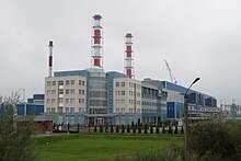
Average yearly power consumption in the Kaliningrad Oblast was 3.5 terawatt-hours in 2004 with local power generation providing just 0.235 terawatt-hours. The balance of energy needs was imported from neighbouring countries. A new Kaliningrad power station was built in 2005, covering 50% of the oblast's energy needs. A second part to this station was built in 2010, making the oblast independent from electricity imports.
In 2008, planning began for the construction of two nuclear power reactors, with costs estimated at €5 billion (US$8 billion).[61] The project was suspended in May 2013, and in 2014, it was abandoned after environmental concerns and lack of support.[62]
See also[]
- Kaliningrad Oblast election, 2011
- Baltic Republican Party
- List of rural localities in Kaliningrad Oblast
- Kaliningrad Special Region
- Kaliningrad question
References[]
- ^ Article 5 of the Charter of Kaliningrad Oblast states that the oblast may have an anthem, providing a law is adopted to that effect. As of 2015, no such law is in place.
- ^ Президент Российской Федерации. Указ №849 от 13 мая 2000 г. «О полномочном представителе Президента Российской Федерации в федеральном округе». Вступил в силу 13 мая 2000 г. Опубликован: "Собрание законодательства РФ", No. 20, ст. 2112, 15 мая 2000 г. (President of the Russian Federation. Decree #849 of May 13, 2000 On the Plenipotentiary Representative of the President of the Russian Federation in a Federal District. Effective as of May 13, 2000.).
- ^ Госстандарт Российской Федерации. №ОК 024-95 27 декабря 1995 г. «Общероссийский классификатор экономических регионов. 2. Экономические районы», в ред. Изменения №5/2001 ОКЭР. (Gosstandart of the Russian Federation. #OK 024-95 December 27, 1995 Russian Classification of Economic Regions. 2. Economic Regions, as amended by the Amendment #5/2001 OKER. ).
- ^ Charter of Kaliningrad Oblast, Article 3
- ^ Charter of Kaliningrad Oblast, Article 17
- ^ Charter of Kaliningrad Oblast, Article 28
- ^ Федеральная служба государственной статистики (Federal State Statistics Service) (May 21, 2004). "Территория, число районов, населённых пунктов и сельских администраций по субъектам Российской Федерации (Territory, Number of Districts, Inhabited Localities, and Rural Administration by Federal Subjects of the Russian Federation)". Всероссийская перепись населения 2002 года (All-Russia Population Census of 2002) (in Russian). Federal State Statistics Service. Retrieved November 1, 2011.
- ^ Jump up to: a b c d Russian Federal State Statistics Service (2011). Всероссийская перепись населения 2010 года. Том 1 [2010 All-Russian Population Census, vol. 1]. Всероссийская перепись населения 2010 года [2010 All-Russia Population Census] (in Russian). Federal State Statistics Service.
- ^ "26. Численность постоянного населения Российской Федерации по муниципальным образованиям на 1 января 2018 года". Federal State Statistics Service. Retrieved January 23, 2019.
- ^ "Об исчислении времени". Официальный интернет-портал правовой информации (in Russian). June 3, 2011. Retrieved January 19, 2019.
- ^ Official throughout the Russian Federation according to Article 68.1 of the Constitution of Russia.
- ^ "Kaliningrad Population 2021 (Demographics, Maps, Graphs)".
- ^ Roqueplo O: La Russie et son miroire d'Extrême-Occident, 2018
- ^ Roqueplo O: La Russie et son Miroir..., 2018
- ^ Roqueplo O: La Russie et son Miroir...2018
- ^ Roqueplo O: La Russie et son Miroir...2018
- ^ Hoffmann, Johann Gottfried (1818). Übersicht der Bodenfläche und Bevölkerung des Preußischen Staates : aus den für das Jahr 1817 mtlich eingezogenen Nachrichten. Berlin: Decker. p. 51.
- ^ Plater, Stanisław (1825). Jeografia wschodniéy części Europy czyli Opis krajów przez wielorakie narody słowiańskie zamieszkanych: obejmujący Prussy, Xsięztwo Poznańskie, Szląsk Pruski, Gallicyą, Rzeczpospolitę Krakowską, Krolestwo Polskie i Litwę (in Polish). Wrocław: u Wilhelma Bogumiła Korna. p. 17.
- ^ Andree, Karl (1831). Polen: in geographischer, geschichtlicher und culturhistorischer Hinsicht (in German). Verlag von Ludwig Schumann. p. 218.
- ^ Hassel, Georg (1823). Statistischer Umriß der sämmtlichen europäischen und der vornehmsten außereuropäischen Staaten, in Hinsicht ihrer Entwickelung, Größe, Volksmenge, Finanz- und Militärverfassung, tabellarisch dargestellt; Erster Heft: Welcher die beiden großen Mächte Österreich und Preußen und den Deutschen Staatenbund darstellt (in German). Verlag des Geographischen Instituts Weimar. p. 41.
- ^ Jump up to: a b Haxthausen, August (1839). Die Ländliche Verfassung in den Einzelnen Provinzen der Preussischen Monarchie (in German). pp. 75–91.
- ^ "Monastery of the Dormition of the Mother of God in Wojnowo (Eckersdorf)". wojnowo.net.
- ^ Tetzner, Franz (1902). Die Slawen in Deutschland: beiträge zur volkskunde der Preussen, Litauer und Letten, der Masuren und Philipponen, der Tschechen, Mährer und Sorben, Polaben und Slowinzen, Kaschuben und Polen. Braunschweig: Verlag von F. Vieweg. pp. 212–248.
- ^ "Old Believers in Poland - historical and cultural information". Poland's Linguistic Heritage. Archived from the original on December 23, 2018. Retrieved December 23, 2018.
- ^ Roqueplo O: La Russie et son Miroir..., 2018
- ^ Roqueplo O: La Russie et son miroir...2018
- ^ "The Potsdam Declaration". Retrieved April 2, 2009.
- ^ Jump up to: a b Milan Bufon (April 11, 2014). The New European Frontiers: Social and Spatial (Re)Integration Issues in Multicultural and Border Regions. Cambridge Scholars Publishing. p. 98. ISBN 978-1443859363.
- ^ Roqueplo O: La Russie et son Miroir d'Extrême-Occident, Langues'O, HAL, 2018
- ^ Roqueplo O: La Russie et son miroir d'Extrême-Occident, 2018
- ^ Roqueplo O: La Russie et son Miroir d'Extrême-Occident, 2018
- ^ "Russia (USSR) / Poland Treaty (with annexed maps) concerning the Demarcation of the Existing Soviet–Polish State Frontier in the Sector Adjoining the Baltic Sea 5 March 1957" (PDF). Retrieved April 2, 2009.
- ^ For other issues of the frontier delimitation see "Maritime boundary delimitation agreements and other material". Retrieved April 2, 2009.
- ^ Weinberg, Gerhard L. (2005). Visions of Victory: The hopes of eight World War II leaders. Cambridge University Press. p. 114. ISBN 978-0-521-85254-8.
- ^ Roqueplo O: La Russie et son miroir d'Extrême-Occident, 2018
- ^ Should Kant's home once again be German?, The Guardian, July 31, 2010
- ^ Jump up to: a b Transit from/to Kaliningrad Region, www.euro.lt Archived November 1, 2009, at the Wayback Machine
- ^ Jump up to: a b eur-lex.europa.eu http://eur-lex.europa.eu/LexUriServ/LexUriServ.do?uri=OJ:L:2003:099:0008:0008:EN:PDF. Missing or empty
|title=(help) - ^ Solnick, Steven (May 29, 1996). "Asymmetries in Russian Federation Bargaining" (PDF). The National Council for Soviet and East European Research: 12. Archived from the original (PDF) on August 28, 2017. Retrieved May 3, 2019.
- ^ Chuman, Mizuki. "The Rise and Fall of Power-Sharing Treaties Between Center and Regions in Post-Soviet Russia" (PDF). Demokratizatsiya: 146. Archived from the original (PDF) on March 8, 2019. Retrieved May 3, 2019.
- ^ "Medvedev Says Russia to Deploy Missiles Near Poland" Associated Press via Yahoo News[dead link]
- ^ Harding, Luke (January 28, 2009). "Russia scraps plan to deploy nuclear-capable missiles in Kaliningrad". The Guardian – via www.theguardian.com.
- ^ "Russia moves missiles to Kaliningrad". BBC News. October 9, 2016.
- ^ Sudakov, Dmitry (November 28, 2011). "Russia's new radar to monitor all Europe including Britain". Archived from the original on December 24, 2013. Retrieved March 10, 2013.
- ^ Russian Federal State Statistics Service (May 21, 2004). Численность населения России, субъектов Российской Федерации в составе федеральных округов, районов, городских поселений, сельских населённых пунктов – районных центров и сельских населённых пунктов с населением 3 тысячи и более человек [Population of Russia, Its Federal Districts, Federal Subjects, Districts, Urban Localities, Rural Localities—Administrative Centers, and Rural Localities with Population of Over 3,000] (XLS). Всероссийская перепись населения 2002 года [All-Russia Population Census of 2002] (in Russian).
- ^ Всесоюзная перепись населения 1989 г. Численность наличного населения союзных и автономных республик, автономных областей и округов, краёв, областей, районов, городских поселений и сёл-райцентров [All Union Population Census of 1989: Present Population of Union and Autonomous Republics, Autonomous Oblasts and Okrugs, Krais, Oblasts, Districts, Urban Settlements, and Villages Serving as District Administrative Centers]. Всесоюзная перепись населения 1989 года [All-Union Population Census of 1989] (in Russian). Институт демографии Национального исследовательского университета: Высшая школа экономики [Institute of Demography at the National Research University: Higher School of Economics]. 1989 – via Demoscope Weekly.
- ^ "ВПН-2010". www.perepis-2010.ru. Archived from the original on December 25, 2018. Retrieved December 22, 2011.
- ^ Переписи населения Российской Империи, СССР, 15 новых независимых государств Census of the Russian Empire, Soviet Union, 15 new independent states Archived May 14, 2011, at the Wayback Machine
- ^ "Age-specific fertility rates (Ru:Возрастные коэффициенты рождаемости)" (PDF). Archived from the original (PDF) on June 5, 2013. Retrieved March 26, 2013.
- ^ Jump up to: a b c "Arena: Atlas of Religions and Nationalities in Russia". Sreda, 2012.
- ^ 2012 Arena Atlas Religion Maps. "Ogonek", № 34 (5243), August 27, 2012. Retrieved April 21, 2017. Archived.
- ^ "Валовой региональный продукт::Мордовиястат". mrd.gks.ru. Archived from the original on February 17, 2018. Retrieved February 19, 2018.
- ^ "Kaliningrad Region – Introduction". Russia: All Regions Trade & Investment Guide. CTEC Publishing LLC. 2008.
- ^ "Regions and territories: Kaliningrad". BBC News. May 15, 2009. Retrieved June 5, 2009.
- ^ Regional administration's website (Russian) Archived September 27, 2007, at the Wayback Machine
- ^ Валовой региональный продукт на душу населения Федеральная служба государственной статистики
- ^ "EDB Fakel". OKB Fakel. Archived from the original on October 12, 2009. Retrieved June 4, 2009.
- ^ "OKB Fakel (Russian Federation)". Jane's Space Systems and Industry. December 17, 2008. Retrieved June 4, 2009.
- ^ How Products Are Made: Amber Archived August 11, 2007, at the Wayback Machine
- ^ "The History of Russian Amber, Part 2: From USSR to Russia" Archived March 15, 2018, at the Wayback Machine, Leta.st
- ^ "Kaliningrad plan for Baltic States market". World Nuclear News. April 17, 2008. Retrieved May 31, 2021.
- ^ Prak, Caroline (April 24, 2014). "Victoire ! Le projet de centrale nucléaire à Kaliningrad est enterré". (in French). Retrieved May 31, 2021.
Sources[]
- Roqueplo O: La Russie & son Miroir d'Extrême-Occident, Langues'O, HAL, 2018
- Областная Дума Калининградской области. Закон №30 от 18 января 1996 г. «О вступлении в действие Устава (Основного Закона) Калининградской области», в ред. Закона №483 от 2 декабря 2015 г «О внесении изменения в Устав (Основной Закон) Калининградской области». Вступил в силу по истечении десяти дней со дня официального публикования, за исключением пункта 5 статьи 15 и подпункта "б" статьи 22 в части подписания постановлений областной Думы председателем областной Думы, которые введены в действие одновременно со вступлением в силу Федерального закона от 06.10.1999 №184-ФЗ "Об общих принципах организации законодательных (представительных) и исполнительных органов государственной власти субъектов Российской Федерации". Опубликован: "Янтарный край", №20, 26 января 1996 г. (Oblast Duma of Kaliningrad Oblast. Law #30 of January 18, 1996 On the Charter (Basic Law) of Kaliningrad Oblast Taking Effect, as amended by the Law #483 of December 2, 2015 On Amending the Charter (Basic Law) of Kaliningrad Oblast. Effective as of the date ten days after the official publication date, with the exception of item 5 of Article 15 and the portion of subitem "b" of Article 22 dealing with the signing of the resolutions of the Oblast Duma by the Chair of the Oblast Duma, which take effect simultaneously with the Federal Law #184-FZ of October 6, 1999 "On the General Principles of the Organization of the Legislative (Representative) and Executive Organs of the State Power in the Federal Subjects of the Russian Federation".).
- Калининградская областная Дума. Закон №463 от 27 мая 2010 г. «Об административно-территориальном устройстве Калининградской области», в ред. Закона №450 от 3 июля 2015 г. «О внесении изменений в Закон Калининградской области "Об административно-территориальном устройстве Калининградской области"». Вступил в силу со дня официального опубликования. Опубликован: "Калининградская правда" (вкладыш "Ведомости Правительства Калининградской области"), №112, 26 июня 2010 г. (Kaliningrad Oblast Duma. Law #463 of May 27, 2010 On the Administrative-Territorial Structure of Kaliningrad Oblast, as amended by the Law #450 of July 3, 2015 On Amending the Law of Kaliningrad Oblast "On the Administrative-Territorial Structure of Kaliningrad Oblast". Effective as of the day of the official publication.).
- Simon Grunau, Preußische Chronik. Hrsg. von M. Perlbach etc., Leipzig, 1875.
- A. Bezzenberger, Geographie von Preußen, Gotha, 1959
- Областная Дума Калининградской области. Закон №30 от 18 января 1996 г. «О вступлении в действие Устава (Основного Закона) Калининградской области», в ред. Закона №483 от 2 декабря 2015 г «О внесении изменения в Устав (Основной Закон) Калининградской области». Вступил в силу по истечении десяти дней со дня официального публикования, за исключением пункта 5 статьи 15 и подпункта "б" статьи 22 в части подписания постановлений областной Думы председателем областной Думы, которые введены в действие одновременно со вступлением в силу Федерального закона от 06.10.1999 №184-ФЗ "Об общих принципах организации законодательных (представительных) и исполнительных органов государственной власти субъектов Российской Федерации". Опубликован: "Янтарный край", №20, 26 января 1996 г. (Oblast Duma of Kaliningrad Oblast. Law #30 of January 18, 1996 On the Charter (Basic Law) of Kaliningrad Oblast Taking Effect, as amended by the Law #483 of December 2, 2015 On Amending the Charter (Basic Law) of Kaliningrad Oblast. Effective as of the date ten days after the official publication date, with the exception of item 5 of Article 15 and the portion of subitem "b" of Article 22 dealing with the signing of the resolutions of the Oblast Duma by the Chair of the Oblast Duma, which take effect simultaneously with the Federal Law #184-FZ of October 6, 1999 "On the General Principles of the Organization of the Legislative (Representative) and Executive Organs of the State Power in the Federal Subjects of the Russian Federation".).
External links[]
| Wikimedia Commons has media related to Kaliningrad Oblast. |
| Wikivoyage has a travel guide for Kaliningrad Oblast. |
- Official website of Kaliningrad Oblast (in Russian)
- A. Liucija Arbusauskaité "The Soviet Policy Towards the "Kaliningrad Germans" 1945–1951" chapter in "Themenheft: Eingliederung und Ausgrenzung. Beiträge aus der Historischen Migrationsforschung. Hrsg.: Jochen Oltmer Osnabrück: IMIS, 1999. ISSN 0949-4723
- Master's thesis by Sergey Naumkin on the possibility of Kaliningrad integrating with the EU as a special economic zone
- Life in Kaliningrad Oblast (in Russian)
- Spuren der Vergangenheit / Следы Пρошлого (Traces of the past) This site by W.A. Milowskij, a Kaliningrad resident, contains hundreds of interesting photos, often with text explanations, of architectural and infrastructural artifacts of the territory's long German past. (in German and Russian)
- City and Reagen News
| show Authority control |
|---|
- Kaliningrad Oblast
- History of Prussia
- Enclaves and exclaves
- Russian-speaking countries and territories
- Germany–Soviet Union relations
- States and territories established in 1946