Kamienna Góra
Kamienna Góra | |
|---|---|
 Town hall | |
 Flag  Coat of arms | |
 Kamienna Góra | |
| Coordinates: 50°47′N 16°02′E / 50.783°N 16.033°ECoordinates: 50°47′N 16°02′E / 50.783°N 16.033°E | |
| Country | |
| Voivodeship | Lower Silesian |
| County | Kamienna Góra |
| Gmina | Kamienna Góra (urban gmina) |
| First mentioned | 1232 |
| Town rights | 1292 |
| Government | |
| • Mayor | Janusz Chodasewicz |
| Area | |
| • Total | 17.97 km2 (6.94 sq mi) |
| Population (2019-06-30[1]) | |
| • Total | 19,010 |
| • Density | 1,100/km2 (2,700/sq mi) |
| Time zone | UTC+1 (CET) |
| • Summer (DST) | UTC+2 (CEST) |
| Postal code | 58-400 |
| Car plates | DKA |
| Website | http://www.kamiennagora.pl |

Kamienna Góra [kaˈmʲɛnːa ˈɡura] (German: Landeshut, Czech: Lanžhot, Kamenná Hora) is a town in south-western Poland with 19,010 inhabitants (2019). It is the seat of Kamienna Góra County, and also of the rural district called Gmina Kamienna Góra, although it is not part of the territory of the latter (the town forms a separate urban gmina).
Kamienna Góra on the Bóbr river is situated in Lower Silesian Voivodeship (from 1975–1998 it was in the former Jelenia Góra Voivodeship) between the Stone Mountains and the Rudawy Janowickie at the old trade route from Silesia to Prague, today part of the National Road No. 5. It lies approximately 95 kilometres (59 miles) south-west of the regional capital Wrocław.
History[]

The area was part of the Great Moravian Empire in the Early Middle Ages, and became part of the emerging Polish state in the 10th century under its first ruler Mieszko I of Poland.[2] During the times of the fragmentation of Poland it was part of the duchies of Silesia, Legnica, Jawor and Świdnica. In the early 13th century, Polish Duke Henry the Bearded erected a defensive castle at the site, due to its proximity to the Polish–Czech border.[2] The settlement was mentioned in documents from 1232 (as Landeshut) and 1249 (as Landishute and Landishute forensis auch Camena Gora). In 1254 the Piast Duke Bolesław II the Bald of Legnica gave the area to the Benedictine monastery of Opatovice (in eastern Bohemia), who already had established Grüssau Abbey at nearby Krzeszów. When the abbey passed to the Cistercians in 1289, Landeshut was acquired by Duke Bolko I the Strict of Świdnica, who extended it as a stronghold against the nearby Kingdom of Bohemia and granted town rights in 1292. It received new privileges from Duke Bolko II the Small in 1334. Nevertheless, the duchy fell to the Bohemian crown with Bolko's death in 1368. It burnt down during the 1426 Hussite campaign to Silesia and in the 1460s it passed to the Kingdom of Hungary, before in 1490 it fell back to Bohemia, then under the rule of Vladislaus II, who erected new town walls.[2]
During the Thirty Years' War the town was plundered by Austrian and Swedish troops.[2] As a result of the war, only two residents remained in the town in 1639.[2] After Frederick II of Prussia had conquered Silesia with Landeshut in 1742, his fierce opponent Maria Theresa of Austria once again struck back in the course of the Seven Years' War. In 1760 Austrian troops under the command of field marshal Laudon invaded the province and on June 23 defeated a Prussian corps under Heinrich August de la Motte Fouqué at the Battle of Landeshut.
The town was not destroyed during World War I and II, but during the latter, the Germans established and operated a subcamp of the Gross-Rosen concentration camp.[2] Around 1,600 men, mostly Poles, and also smaller groups of other ethnicities, were imprisoned and used as forced labour in the subcamp, and many of them died.[3] There was also a forced labour camp for Jews.[4] It was captured by the Soviets on May 9, 1945, and after the war it became part of Poland.[2] According to the Potsdam Agreement the German populace was expelled[citation needed] and the town was repopulated by Poles, expellees from former eastern Poland annexed by the Soviet Union and settlers from central Poland.[2] Initially renamed to the 19th-century Polish name Kamieniogóra,[5] in 1946 the name Kamienna Góra, which was first recorded in 1249, was adopted.
Sights[]
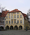
The main historic district of Kamienna Góra is the Old Town (Stare Miasto) with the Freedom (Plac Wolności), Grunwald Squares (Plac Grunwaldzki) and Brewery (Plac Browarowy) Squares, filled with numerous historic buildings. Among the historic sights of Kamienna Góra are:
- Gothic churches of Saints Peter and Paul and Corpus Christi
- Baroque Church of Our Lady of the Rosary
- Town Hall
- Weaving Museum (Muzeum Tkactwa)
- Lower Silesian Rehabilitation Center (Dolnośląskie Centrum Rehabilitacji)
- Culture Centre (Centrum Kultury)
- ZUS office
- preserved medieval town walls
- ruins of the Grodztwo Castle
- numerous historic townhouses and buildings, incl. the train station, tax office, high school, courthouse, etc.
There are also several monuments dedicated to the victims of the local branch of the Nazi German Gross-Rosen concentration camp.
Gallery[]

Kamienna Góra with Karkonosze mountain range
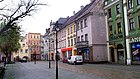
Historic townhouses at the Freedom Square

Town Hall
Weaving Museum (Muzeum Tkactwa)

Lower Silesian Rehabilitation Center
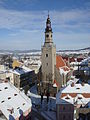
Gothic Church of Saints Peter und Paul
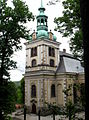
Baroque Church of Our Lady of the Rosary

Culture Centre

Architectural decorations of one of the old townhouses

ZUS office

High school (Liceum ogólnokształcące)

Train station

Grodztwo Castle ruins
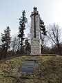
Memorial to murdered prisoners of the local branch of the Nazi German Gross-Rosen concentration camp

Sacred Heart of Jesus Church

Courthous


Notable people[]
- Walter Arndt (1891–1944), zoologist
- Gosia Dobrowolska (born 1958), actress
- Rudolf Hamburger (1903–1980), architect and spy
- Viktor Hamburger (1900–2001), biologist
- Carl Gotthard Langhans (1732–1808), architect, designer of the Brandenburg Gate
Twin towns – sister cities[]
Kamienna Góra is twinned with:[6]
 Bitterfeld-Wolfen, Germany
 Dvůr Králové nad Labem, Czech Republic
 Ikast-Brande, Denmark
 Ivangorod, Russia
- Trutnov, Czech Republic
 Vierzon, France
- Wolfenbüttel, Germany
References[]
- ^ "Population. Size and structure and vital statistics in Poland by territorial division in 2019. As of 30th June". stat.gov.pl. Statistics Poland. 2019-10-15. Retrieved 2020-02-14.
- ^ Jump up to: a b c d e f g h "Historia". Starostwo Powiatowe w Kamiennej Górze (in Polish). Retrieved 9 February 2020.
- ^ "Subcamps of KL Gross- Rosen". Gross-Rosen Museum in Rogoźnica. Retrieved 10 September 2020.
- ^ "Zwangsarbeitslager für Juden Landeshut". Bundesarchiv.de (in German). Retrieved 10 September 2020.
- ^ Kazimierz Rymut, Nazwy miast Polski, Ossolineum, 1987, p. 99 (in Polish)
- ^ "Współpraca z zagranicą – Miasta partnerskie". kamiennagora.pl (in Polish). Kamienna Góra. Retrieved 2020-02-28.
External links[]
| Wikimedia Commons has media related to Kamienna Góra. |
- Official town website
- Jewish Community in Kamienna Góra on Virtual Shtetl
- Satellite photo from Google Maps
- News from local area
| hide Gminas of Kamienna Góra County | ||
|---|---|---|
| Seat |
|  |
| Urban-rural gmina | ||
| Rural gminas | ||
| hide | ||
|---|---|---|
| Villages |  | |
| Seat (not part of the gmina) | ||
| show Authority control |
|---|
- Cities and towns in Lower Silesian Voivodeship
- Kamienna Góra County
- Cities in Silesia