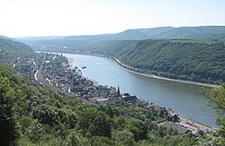
Kamp-Bornhofen
Kamp-Bornhofen | |
|---|---|
 | |
 Coat of arms | |
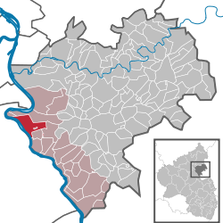
show Location of Kamp-Bornhofen within Rhein-Lahn-Kreis district | |
 Kamp-Bornhofen | |
| Coordinates: 50°13′30″N 7°37′20″E / 50.22500°N 7.62222°ECoordinates: 50°13′30″N 7°37′20″E / 50.22500°N 7.62222°E | |
| Country | Germany |
| State | Rhineland-Palatinate |
| District | Rhein-Lahn-Kreis |
| Municipal assoc. | Loreley |
| Government | |
| • Mayor (2019–24) | Frank Kalkofen[1] |
| Area | |
| • Total | 11.37 km2 (4.39 sq mi) |
| Elevation | 69 m (226 ft) |
| Population (2020-12-31)[2] | |
| • Total | 1,556 |
| • Density | 140/km2 (350/sq mi) |
| Time zone | UTC+01:00 (CET) |
| • Summer (DST) | UTC+02:00 (CEST) |
| Postal codes | 56341 |
| Dialling codes | 06773 |
| Vehicle registration | EMS |
| Website | www.kamp-bornhofen.de |


Kamp-Bornhofen is a municipality in the district of Rhein-Lahn, in Rhineland-Palatinate, in western Germany. Sights in Kamp-Bornhofen include the well known castle Liebenstein.
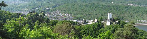
Burg Liebenstein and Burg Sterrenberg, known as the Feindliche Brüder (“Adversarial Brothers”) after a German legend that arose in the 16th century
References[]
- ^ Direktwahlen 2019, Rhein-Lahn-Kreis, Landeswahlleiter Rheinland-Pfalz, accessed 5 August 2021.
- ^ "Bevölkerungsstand 2020, Kreise, Gemeinden, Verbandsgemeinden". Statistisches Landesamt Rheinland-Pfalz (in German). 2021.
External links[]
| Wikimedia Commons has media related to Kamp-Bornhofen. |
- Painting of Bornhofen, J.F. Dielmann, A. Fay, J. Becker (painter): F.C. Vogels Panorama des Rheins, Bilder des rechten und linken Rheinufers, Lithographische Anstalt F.C. Vogel, Frankfurt 1833
- Painting of Camp 1, dito
- Painting of Camp 2, dito
- Painting of Camp 3, dito
| show Towns and municipalities in Rhein-Lahn-Kreis |
|---|
| show Authority control |
|---|
This Rhein-Lahn location article is a stub. You can help Wikipedia by . |
Categories:
- Municipalities in Rhineland-Palatinate
- Rhein-Lahn-Kreis
- Middle Rhine
- Duchy of Nassau
- Rhein-Lahn-Kreis geography stubs