Kamsar
This article needs additional citations for verification. (August 2020) |
Kamsar | |
|---|---|
Sub-prefecture and city | |
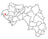
 Kamsar Location in Guinea | |
| Coordinates: 10°39′N 14°37′W / 10.650°N 14.617°WCoordinates: 10°39′N 14°37′W / 10.650°N 14.617°W | |
| Country | |
| Region | Boke Region |
| Prefecture | Boké Prefecture |

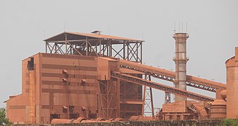
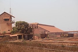
Kamsar is a port city in Guinea, West Africa. It is also a Sub-prefecture of Guinea. It is located on the mouth of the Nunez River.
Transport[]
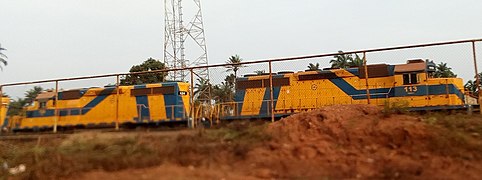
It has a standard gauge railway line feeding bauxite from the mine at Sangarédi to the port.
The city is served by Kawass Airport.
Climate[]
Kamsar has a tropical monsoon climate (Am) with little to no rainfall from December to April and heavy to extremely heavy rainfall from June to October with moderate rainfall in May and November.
| hideClimate data for Kamsar | |||||||||||||
|---|---|---|---|---|---|---|---|---|---|---|---|---|---|
| Month | Jan | Feb | Mar | Apr | May | Jun | Jul | Aug | Sep | Oct | Nov | Dec | Year |
| Daily mean °C (°F) | 26.2 (79.1) |
26.4 (79.6) |
27.9 (82.3) |
28.7 (83.6) |
28.4 (83.2) |
26.8 (80.3) |
25.9 (78.7) |
25.7 (78.3) |
25.8 (78.5) |
26.3 (79.4) |
26.3 (79.4) |
24.9 (76.9) |
26.6 (79.9) |
| Average rainfall mm (inches) | 0 (0) |
0 (0) |
0 (0) |
6 (0.2) |
72 (2.8) |
305 (12.0) |
772 (30.4) |
999 (39.3) |
465 (18.3) |
304 (12.0) |
70 (2.8) |
5 (0.2) |
2,998 (118) |
| Source: Climate-Data.org (rainfall)[1] | |||||||||||||
See also[]
- Transport in Guinea
- Railway stations in Guinea
External links[]
References[]
- ^ "Climate: Kamsar". Climate-Data.org. Retrieved August 8, 2020.
| show Authority control |
|---|
This Guinea location article is a stub. You can help Wikipedia by . |
Categories:
- Sub-prefectures of the Boké Region
- Guinea geography stubs